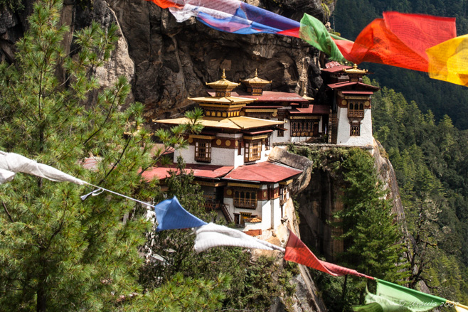
Paro Taktsang
Perched about 900 metres (or 3,000 ft) above the Paro Valley, the Tiger’s Nest is a sacred Himalayan Buddhist temple complex.
A friend of mine is currently bicycling around Bhutan.
Bhutan! That magical, mysterious, land-locked country on the southern slopes of the eastern Himalayas where happiness is valued and elevations range from 200 m (660 ft) to more than 7,000 m (23,000 ft). Cycling! What a wonderful, life-embracing, inspirational woman she is.
In spite of watching her progress with total awe and some envy, I haven’t been moved to ride my own bicycle for more than a toddle around the block. I was motivated, however, to revisit my Bhutanese photo-set from this time four years ago.
September is festival season in Bhutan: a wonderful period of colourful costumes, dancing and celebration – and that’s what we were there to photograph. (Two of the banner photos ([1], [2]) on this website are from one of Bhutanese festivals I attended while there – more about that some other time.) Our first complete day on the ground, however, was spent hiking up to The Tiger’s Nest – that sacred collection of monastery and temple buildings perched some 3,120 metres (10,240 ft) above sea level.
Our itinerary said the climb would take about two hours, and we’d be back in Paro for lunch. This seems, in retrospect, rather optimistic. Every travel site I’ve looked at suggests allowing 2-4 hours for the uphill portion, and doing it after you have acclimatised to the altitude.
I suppose we could (possibly?) have walked it faster than we did, but who would want to? It is a truly beautiful hike – even if rather more strenuous than the guide book suggested. We started trudging up, up, and more up, just before eight o’clock. The dirt path sets off gently enough through tall blue pine and it wasn’t long before we spotted our first stream tumbling downhill to meet us. Across the stream, gaily painted white-washed buildings (chorten) house water-driven prayer wheels. Large stones nearby are painted with prayers and images of Guru Rinpoche (Padmasambhava, “The Lotus Born”).
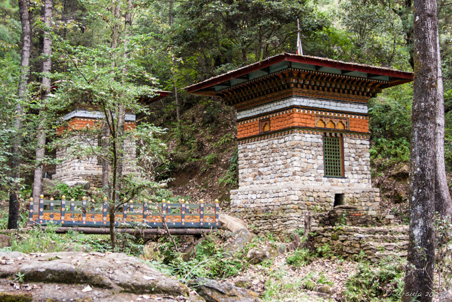
Chorten
Prayer wheels, driven by water-wheels in the running stream, sit inside white chorten or stupas.
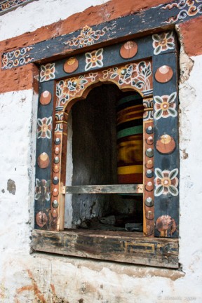
Spinning, Spinning
Prayer wheels spin inside their chorten – their speed determined by the stream waters.

Distant Monastery
Clouds shroud the mountaintops above the cliff, where the monastery is barely visible.

Photographers in a Field
We have climbed very little so far; it is still a long way up to the temple.
From a field off the trail, we were able to look up, way up, to where the Tiger’s Nest perches impossibly on a neighbouring mountain peak, 900 meters above the Paro Valley below. Wow! I got vertigo just looking at it.

Bronze Bell
Religious items, jewellery and some souvenirs are for sale along the route.

Bhutanese Beauty

Streams and Trails

Selling Jewellery
An old Bhutanese woman sits with her jewellery and trinkets.

Flags and Flowers
Prayer flags blow in the breeze and flowers line our rocky, dusty path.

Cairns
Memorials for the departed punctuate the trail.
As we continued the walk up hill, through birdlife and trees draped in Spanish Moss and prayer flags, we came to a sign: “Walk to Guru’s glory! … For here in this Kingdom rules an unparalleled benevolent King.” This is the realm of Guru Rinpoche who, in the form of Doriji Drakpo, one of his eight manifestations, flew to the top of this mountain on a flaming tigress, giving rise to the monastery name: “Taktshang” or “Tiger’s Nest”.
Up and up we tramped: past small stone cairns in memory of the dead; past trinket sellers with an abundance of yak bone and mountain-coral jewellery, and religious objects in silver and bronze; past wild flowers and prayer wheels; until we finally reached the half-way point – the cafeteria rest stop (2940) – by ten o’clock. I asked what time we were supposed to reach the top, and was told: “Fifteen minutes ago!” Hmm.
Already, one of our group of nine had resorted to riding one of the sturdy horses that service the lower half of the track. Now, it is true that none of us were particularly young and most of us had been living at sea level in Bangkok, and therefore were not used to the altitude, but seriously – two hours all the way up???

Prayer Wheel
Our guide does the requisite three laps of the prayer wheel.

Wind Horse (Lung Ta) Flags
Prayer flags are strung everywhere.

Trinkets in the Sun

Phallic Symbols for Sale
Phallic symbols in Bhutan are vested with the power to ward off evil spirits.

Taktsang Cafeteria
The cafeteria serves coffee and meals, and affords a great view of Tiger’s Nest.

Prayer Cloth
According to legend, the Shakyamuni Buddha’s prayers were written on battle flags.

Flags to the Wheelhouse
Horizontal lung ta and vertical darchor flags set off the golden pagoda.

Wind Horse Flags
Lung ta flags spread prayers on the wind with the speed of a horse, apparently.

View to the Tiger’s Nest
As the trail winds upward, there are regular glimpses of the temple.

Spanish Moss
The pine forest is draped with lacy moss.

Meditation House
The deep, rumbling sounds of of a monk chanting came from this little house as we passed.
After drinking cups of tea or coffee and stripping off excess clothing, those of us who continued to the top took plenty of pictures, pausing regularly as we wended our way up, up, and more up. This was not only as an excuse to stop and breathe – it really was one of the nicest trails I have ever trekked.
It is true what they say: at the lookout, you feel you as if you could reach out and touch the monastery across the ravine. The bad news is that to actually get to it, you need to climb down and up again on the other side. It probably isn’t that far, but it is steep and I wasn’t the only one gasping for air!

The Tiger’s Lair
It looks so close you could reach out and touch it!

Waterfall
The path from the viewpoint to the temple drops down over a 60 meter fall.

Look Up… Way Up…
The entry to the temple is decorated in traditional Bhutanese manner.

Monks at Tiger’s Nest

Stone Stairs

Looking back at Taktsang

Prayers on the Wind

Yellow Wildflowers

Another Beauty

Fallen Prayer Flag
After visiting various altar rooms in the monastery (without our shoes, hats or cameras, as per requirements), we set off back down the hill to collect our missing group members at the coffee house.
One of the hallmarks of the Bhutanese has to be their flexibility; when it became clear we were going to be nowhere near Paro by lunch time, our guide arranged for our lunch to come to us! Once we had finally made our way back down the hill, our food was waiting, and mid-afternoon, seated on cushions in a field, we finally ate our well-deserved meal.
There is a real risk when going back to old photos: they were taken with an old camera and processed with an old version of Lightroom, so everything had to be re-edited. Then, looking at the framing or aperture or lack of clarity, there were all those “What was I thinking??” moments…
 But, I loved Bhutan when I was there, and I enjoyed revisiting some of my photos from this happiest of Himalayan Kingdoms.
And it was ever so much easier than cycling!
Happy Travels.
Pictures: 24September2009


.jpg)


.png)
Beautiful photos & and your usual beautiful writing. Enjoyed it.
Thanks to my #1 fan! 😀
Nice article Ursula, Bhutan remains on my bucket list. One day!
PS: Is that Gavin Gough’s umbrella in one shot? 🙂
Hey, Kevin! That’s not Gavin’s umbrella (too colourful for a Brit!) but his back is in one shot. 🙂
[…] first full day in the country was spent hiking to Tiger’s Nest, high over the Paro Valley. Then it was time to hop in a minibus, and cross some of the rugged […]