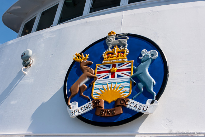
Splendor Sine Occasu
“The Sun Never Sets…” or “Brilliance without Setting”
The shield of the province of British Columbia is proudly displayed on the prow of the government-owned ferries.
If you grew up in one of the many protectorates or dominions of the British Commonwealth, and are as old as I am, you will remember a world map in the classroom, covered in pink.
British Columbia, on the west coast of Canada, was the last bit of pink on the left – before the map ended and the lowering sun ran into the international dateline. Those maps harked back to the days in which the sun never set on the British Empire.
Of course, that ship has long since sailed; the sun did set. But, some of the ideals and symbols endure. I found it interesting to look up the elements of the British Columbia shield, which is proudly displayed on the prow of all the provincial ferries. Little changed from the original version drawn in the 1890s, the design reflects the sentiments of the day: the Queen’s royal crest above a shield incorporating an antique crown and the Union Jack above a sun, lowering itself into the the waves of the Pacific Ocean. The “supporters” are the wapiti (elk) of Vancouver Island in the west, and the bighorn sheep of the mountains in the east.
Sun, water and wildlife – and a tip of the hat to the British royalty; the shield sums it up, really. Of course, the old regime pretty much ignored the rich cultural and artistic practices of the local First Nations people. While that acknowledgement is still missing from the crest and shield, symbols originating out of Indigenous traditions can be seen everywhere else.
There is no better place to be than the west coast of British Columbia – the heart of the Pacific North West, especially in good weather. I’d return to the area even if I didn’t have family to visit on both sides of the Strait of Georgia.
If you want to drive, the BC Ferries are the vital links in the road system that get you from inlet to island to peninsula and back – through a landscape of trees and mountains and waterways where no bridges reach.
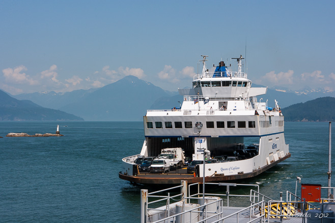
The Queen of Capilano
We watch one of the smaller BC ferries come into dock at Horseshoe Bay, thirty minutes north of Vancouver. Most of the ferries are “queens”, and most have indigenous tribal names. Capilano was a Squamish chief, after whom many local places were named.
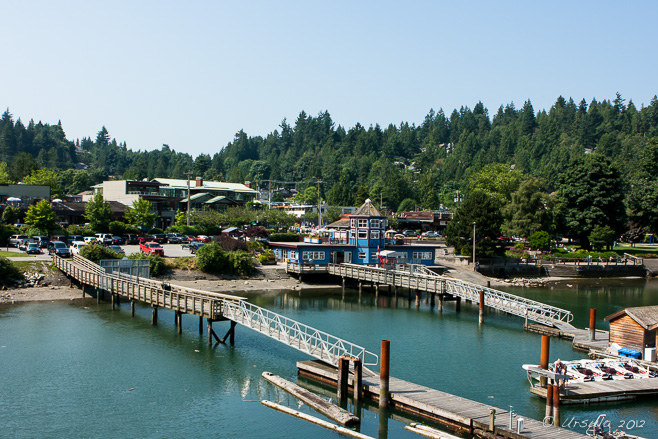
Leaving Horseshoe Bay
Ferry travel is very civilised (if rather expensive!): after paying, you can park your car in the queue and wander over to the local shops or restaurants to pass the time before being called back to your vehicle.

In our Wake
The waters of Howe Sound are protected and scenic…

Howe Sound Islands
… as we wend our way past the islands of Bowen and Keats to the south of us, and Gambier to the north.

Persephone
The next day, in the small coastal community of Gibsons, we lunched at Molly’s Reach and had a look at Persephone, the steel logging tug that featured in The Beachcombers, Canada’s longest-running English-language drama. In production from 1972 to 1990, the show put the local area on the map. My mother was an extra in two of the 387 episodes, and my children later watched syndicated episodes in Australia, half a world away.

Welcome to Sechelt
The lower Sunshine Coast community of Sechelt, the “land between two waters”, just 25 minutes further up the road, is still home to the Sháshíshálh Indian Band, as well as newer arrivals – mostly retirees from nearby Vancouver. It also boasts atmospheric rocky beaches and lush green parks.

Sunbeams ~ Earls Cove
Another day, and another short stretch of drive up the lower Sunshine Coast Highway, through tall douglas firs and quaint coastal housing. After a quick hike to marvel at the “strong waters” of Skookumchuk Narrows, we sit in the afternoon sun, waiting for our next ferry to unload.

Leaving Earls Cove
On this leg of the journey, we take a small ferry the 18 km across Jervis Inlet from Earls Cove to Saltery Bay. (I like the hand print that is visible on the window I’m shooting through; someone has been climbing!)

Flying the Flags
Three flags flying at the top of our ferry: the Canadian, the Provincial, and the BC Ferries.

Watching Water
It is a pleasant – if cool – afternoon on the waters …

Jervis Inlet Waters
… and the view is always changing.

Saltery Bay
After an hour on the boat, we dock at Saltery Bay, disembark, and drive the 30km up the Sunshine Highway to Powell River…

Powell River Sunset
… where we are treated to a magnificent sunset after a delicious dinner.

Queen of Burnaby Bell
Early the next morning, we were on another ferry –

Ropes ~ Ship-Shape
– this time for an hour and twenty minutes across the Strait of Georgia (the Salish Sea) –

Rusty Chains
– between Powell River on the northern Sunshine Coast and Comox on Vancouver Island.

Yellow Cedar
Back on land on Vancouver Island, we detoured forty-five minutes north …

Wood Working
… to visit the Museum at Campbell River and learn something about the old timber industry.

Red Snapper
The museum has an excellent First Nations exhibit, but you can’t take photos inside. I had to content myself with pictures of the artwork in the gift shop.

Blackberries (Rubus fruiticosus)
It is the end of July, and the blackberries are still forming. I thought these were salmonberries – the correction is thanks to a sharp-eyed reader. 😀

Driftwood
Old logs wash up on the beaches.

Transformations on the Shore
A little further down the road, the results of the annual “Transformations on the Shore” chainsaw carving competition are still on display.

Sun
Many of the carvings incorporate traditional Pacific Northwest First Nations designs;

Eagle
… new renditions of age-old themes.
 Although we have travelled around the southern portions of the Sechelt Peninsula and Vancouver Island before, this was the first time we’ve been able to drive the northern parts of the circuit.
I look forward to the day when we have the time to explore it more fully.
Until then, Happy Travels!
Pictures: 27-30July2012



.png)
