
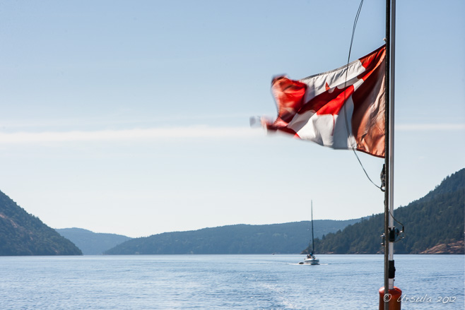
Flag over the Stuart Channel
A flag flaps wildly as a sailboat motors through the protected waters of British Columbia’s Southern Gulf Islands.
“Land was created to provide a place for boats to visit.”
-Brooks Atkinson
There are those who sail just for sailing’s sake: for the feel of the wind, the rush of the waves, and the challenge of managing a boat and the elements. As much as I enjoy the physical activity of sailing, I also love it as a means to an end: as a way of being part of the natural environment, and as a way of visiting new locations.
“Travel” takes on a whole new dimension when you are at the helm of a boat on the water. There is a real feeling of freedom that comes with a good day’s sailing: the joy of slicing through the waters towards places that might otherwise be inaccessible.
Of course, in a sailboat, access to those destinations is dependent on the the whims of the winds, the turn of the tides and the sailor’s own abilities. My husband and I get out onto the water whenever we are able, which, unfortunately, is not often enough to make us very good sailors. But, when the opportunity presented to travel with another boat through the tricky Dodd Narrows into the Southern Gulf Islands, we jumped at it. What we lack in skill, we make up in enthusiasm.
We had already been out sailing several days on Graystone, a comfortable 38-foot Hughes (On the Straits and Narrows (Part 1)), so we had our sea legs. Even so, traversing the 60-metre-wide Dodd Narrows had me nervous. Timing is everything: in a sailboat, the Narrows can only be safely crossed under motor and around slack tide. The currents run between 6 and 10 knots, with rips and eddies even during the short slack tide: that six-minute interval, four times a day, when the tide pauses briefly before changing direction.
So, even with careful planning, I was happy to have more-seasoned sailors in a companion boat to keep an eye on us – and to join us in exploring new landfalls.
Into the Narrows
The crossing through Dodd Narrows has to be planned carefully to coincide with slack tides.
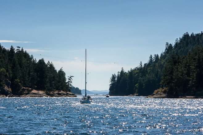
Sails and Mountains
Once through the challenging rips of Dodd Narrows, you are in amongst the Southern Gulf Islands; the potential for exploration is almost limitless.
Thetis Island, a sheltered little gem (2,560 acres ~ 4 sq. miles) across the Stuart Channel from the community of Chemainus on Vancouver Island, is one of those places only accessible by water: seaplane, scheduled ferry, or your own boat.
First Nations people have lived around the area for 8000 years, and Europeans have been settled on the island since the late 1800s. Today, the population stands at 350 people: mostly engaged in managing holiday rentals and Christian church camps. The one-room elementary school has room for up to 50 young children; older students make the daily ferry trips to Vancouver Island. Classified as an “unincorporated community”, the island has no public lands and is self-managed through a special “Islands Trust” administration.
As small as the island is, it’s sheltered location makes it popular with boats cruising in the Gulf Islands. There are two privately-operated marinas. We booked our boats into the smaller of the two, at Telegraph Cove.

Telegraph Harbour Marina
The sun lowers in the sky as we settle into our moorings at Telegraph Harbour Marina on Thetis Island.
Shallow Waters
The waters around our mooring at Telegraph Bay on Thetis Island are green, shallow, and surrounded by trees.
Night Fisherman
We were amused to find an old Asian night fisherman guarding the Telegraph Bay Marina shopfront.
Pennants
Flags from yacht clubs around the world decorate the rafters of the barbecue shelter at the Telegraph Harbour Marina.
Jellyfish
Like eggs with tentacles, jellyfish float in the waters of Telegraph Harbour.
Dinghy
Our travel companions explore the waters of Telegraph Harbour.
Rocky Point
The shoreline around Telegraph Harbour is rocky and uneven.
Wildflowers
Thetis Island lies in a rain shadow, giving it a mild, relatively dry, climate.
Maple Bay Marina
We spend our second night moored at Maple Bay, Duncan, on Vancouver Island. In the morning the light on the waters is stunning.
Towards Crofton
Against the backdrop of Vancouver Island, the Crofton Pulp Mill stands out as one of the few examples of industry.
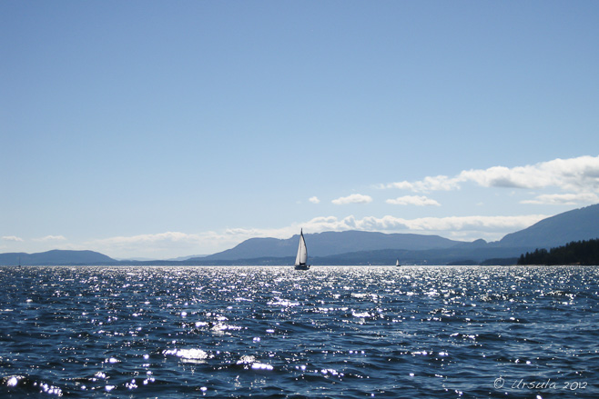
No Wind!
It’s slow motoring when the winds won’t blow…
Sheltered from Georgia Strait by the much large Valdes and Gabriola Islands, DeCourcy Island (about 460 acres) feels miles away from the “real world”.
Not only does the island have no ferry service – access is by boat or float-plane only – the only marina is restricted for residents (most of whom are weekenders or holiday stays) only. Property advertisers tout the “Off the Grid Island Life”: the few available house lots need to organise and maintain their own power, water and septic services.
We dropped anchor in the calm waters of the bay at the south end of the island, right next to the 76-acre Pirates Cove Marine Provincial Park.
Anchoring at DeCourcy
In the sheltered bay at the south end of DeCourcy Island, we drop anchor for lunch on the boat, …
Dinghy on DeCourcy
… then take a dinghy ashore for a walk …
Harbour on DeCourcy
… along Pylades Trail, where we have views down over the harbour.
Natures Abstracts: Curling Arbutus Bark
Pine Cones
Grasses
The bright afternoon sun glints through the grasses on the hill.
Sailboat
From the trail we watch another boat motoring into the south harbour at DeCourcy.
Treasure Chest
In order to live up to it’s name: Pirates Cove Marine Provincial Park, a treasure chest full of plastic beads and fake gems sits on the point, not far from the warning beacon and overlooking the boats in the residents-only marina.
Oak Leaves
The BC Parks site helpfully states: “Poison oak can also be found along steep rock outcroppings in the cove.” Unfortunately, they don’t include pictures. I think this is the more-common Gary Oak (Quercus garryana). Still, I didn’t touch it; just in case!
Brother XII Trail
Brother XII, born as Edward Arthur Wilson in Britain in 1878, was a self-proclaimed mystic and founder of the Aquarian Foundation, a spiritual group – or cult. With money from his many followers, he bought tracts of land on DeCourcy and nearby islands to build a self-sufficient community. Before long, cracks in the planned Utopian lifestyle lead to a series of sensational court battles. He is said to have fled to Switzerland with the Foundation’s money.
Still Waters
As we make our way back to the harbour, the still waters of DeCourcy are a sharp contrast to the Dodd Narrows which we must face again – this time travelling north.
Tugboat and Log Boom
We sit at the south end of Dodd Narrows, glued to our radios. Working tug boats with their massive log booms get right-of-way, so we wait for our turn.
Log Boom
The massive logs are chained together, but you don’t want to get too close – and you really don’t want to meet a log that has broken free!
Twilight
Daylight is fading as we chug north through Newcastle Island Passage to Nanaimo.
Nightfall
On the way back to our mooring, we learn the truth of another sailing axiom attributed to Francis Stokes: “The sea finds out everything you did wrong.”
For, it turned out our running lights were not working. Like an old-fashioned figurehead, or Kate Winslet in the Titanic, I stood at the prow of the boat with a flashlight, making sweeps across the dark waters in front of us, tying to see and be seen. Even at night Newcastle Island Passage is busy with tugs, fishing boats and the massive BC Ferries.
 It was with a relieved sigh we found our “home” berth and tied up safely, had a quick drink at the local pub, and reflected on another great sail – and some great landfalls.
Until next time ~
Safe Sailing!


Photos: 3-5November2012


")
