There is something special about being a “visitor” instead of a “tourist” when you are travelling: getting a glimpse into the real, everyday lives of ordinary people, rather than the “show homes” set up by tour operators.
Portrait: A Rural Khmer Family, Proyyut Village, Cambodia
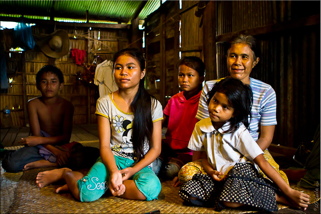
Let me introduce you to an “average” rural Khmer family: Mum and her four children.
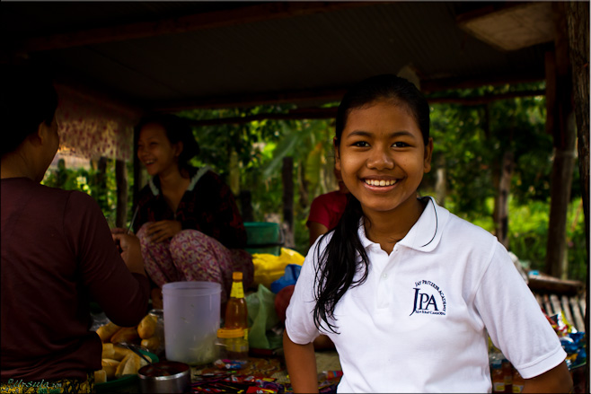
I met Sony, the eldest of the four siblings, the first morning I visited Sandan School. She’s a bright girl, and was lucky enough to be chosen to attend the Jay Pritzker Academy (JPA), an American school which provides free schooling, uniforms and materials to about 365 students in the local area.
Fourteen-year old Sony is a student at JPA.
Sony is delightfully self-possessed and easy to talk to. Her schooling may account for some of this: JPA’s vision is to be “the best school in Cambodia and competitive with the best schools worldwide” while keeping students integrated with their local communities and cultural values. Her English is excellent, and we were able to chat about a range of topics: from health, education, and social issues in Cambodia, to the country’s history, and her personal plans for the future.
I later discovered that Sony’s youngest sister, Nana (age 5), was one of the students I had focussed on in the Sandan School first grade classroom.
Nana Sweeping
Nana and her classmates at their first-grade classroom window.
Nana in the Classroom
As part of the photo-tour I was participating in (under the guidance of Karl Grobl, Marco Ryan, Gavin Gough and Matt Brandon), I was expected to create a photographic essay with another group participant. We wanted to focus on one student: at home and at school. Having Sony as our guide and liaison made this possible, and we arranged to visit Nana and Sony at their home in a neighbouring village.
It was raining the first afternoon we went to visit. When we turned off the last bit of asphalt and onto a slippery red dirt road with potholes big enough to swallow our tuk-tuk, our driver showed serious reluctance about continuing. Sony had given him directions, but we still had to stop several times to ask for directions. There were no signposts and the lots were not numbered.
The family lives in a bamboo house on stilts, next door to a similar house on the same farming allotment, belonging to a member of their extended family. I was grateful I was wearing plastic shoes: there was no “driveway” – the houses are reached by picking your way over the least-wet patches of ground.
Sony and Nana's home in Proyyut Village, Cambodia.
Corrugated iron house on stilts: no windows, ladder entry
Rusty corrugated-iron house siding.
Auntie next door, with her baskets. The red marks on her forehead are from hot-cupping, a local remedy for headache and other ailments.
The families grow rice for their own consumption. As Sony said: if they sold it, they would not have enough for next season’s planting. Auntie owns the land. She makes baskets which she sells at the local market for 100 reils (KHR) each: about two cents American. Sony and Nana’s mother also weaves baskets when she has finished tending the rice and other crops. She has been widowed for three years now: Sony and Nana’s father died of stomach problems in 2008, leaving mum to manage on her own. Sony still finds it hard to talk about him, but showed me the shrine with his picture in it in a corner of the “living room”.
Mum at Home
Gran lives close by. She came over to get a look at the strangers.
Nana and her sister at home: a hammock under the house.
Nana’s middle sister Srai Ranoch is in grade four at Sandan School. Her class attends in the afternoons, while Nana’s is in the morning, so they are not actually in school at the same time. They are fortunate to have Sony at JPA because it relieves some of the financial pressure on the family. Even though schooling is free, each child is expected to contribute towards tests and materials. While this contribution is small, it represents a huge proportion of the meagre family income. Their brother, who is thirteen, dropped out of school three years ago to help Mum with the fields. Sometimes he is able to earn a little money helping the neighbours.
Nana and her brother
Cousins: Foreign visitors are uncommon in this little village, so the cousins next door have come over for a look.
Nana dancing with her dog.
The second time we went to visit, the sun came out, and with it came even more of the neighbouring children. They all led us on a wonderful excursion through the rice patties and fields that comprise their back yard.
Cousin up a Tree
Getting fresh coconut for the visitors.
Afternoon rainbow in the rice fields.
Blue Toad
Summer Rice
Worker tilling the rice fields
Girl in a rice field
Bringing in the cows.
Time for a chat: Sony, Nana and their cousin take time out.
End of the day: afternoon on the rice patties.
We were grateful to Sony and her family for letting us visit, and giving us an insight into their lives.
I hope they both continue to study hard and build a better future for themselves and their family.
Hi Lisa and Signe!
These people have such sadness in their pasts and difficulty in their presents, but they still make it so easy to make pictures around them. It was a joy to visit them. 🙂ReplyCancel
Thanks, Sanan!
It’s great to have your company for the trip. 🙂ReplyCancel
lissillour -October 18, 2013 - 2:46 pm
A very moving testimony of the reality of life Cambodge.Chaque family has its own story more or less happy, but this country has a very difficult to forgive recent history.
But Cambodians are very intelligent and hardworking people.
Thank you for this story that I for one am also on FLICKR.ReplyCancel
Coming into School in the Morning – Sandan School, Cambodia
Cambodia is a youthful country with a sad history.
One third of the country’s 15 million people (32.2%) is under the age of fifteen (July 2011 est.).
Given the genocide perpetrated by Pol Pot and the Khmer Rouge between 1975-1979 when two million Cambodians were killed, it is not surprising that less than 4% of the population is 65 or over. During the Khmer Rouge regime, educated people were targeted in the name of “agrarian socialism”. Thousands of teachers were amongst those executed after the fall of Phnom Penh in 1975.
So, the education system had to rebuild from scratch, along with the rest of the country’s infrastructure, and this could only start properly after the end of the civil war in 1990. Today, there are a lot of children – and still too few educated adults. This puts a lot of pressure on the country’s schools. On average, students stay in school for ten years, attending half a day of classes (four hours), either in the morning or in the afternoon, six days a week. Those who can afford it also attend evening “tutoring” classes. A number of parents told me that many teachers put all their energy into these tutoring classes; they said that teachers ignore the curriculum during their normal classes so that students have to pay the extra if they wish to pass the exams. If true, this is disappointing, but, given teachers’ pay scales and work loads, not terribly surprising.
I’ve visited Cambodia a number of times in the past to participate in an annual professional conference for the local teachers. This latest trip, however, was for me – I was there with my camera and with four gifted professional photographers: Karl Grobl, Marco Ryan, Gavin Gough and Matt Brandon. Still, I couldn’t resist visiting a local school, to see what was happening.
Arriving at School in the Morning – Sandan School, Cambodia
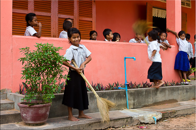
As you’d expect, the schoolyard in the morning is a lively place. Children arrive early: on foot, on oversized bicycles, ferried by their older siblings, or piled onto motorcycles or scooters driven by parents on their way to work. Children buy snack food from local vendors. They sweep the rooms and the yard, and unstack the desks in the classrooms. The boys play tag or marbles in the packed-dirt yard, while the girls skip or play a local version of Jacks on the veranda – all before the bell rings at eight o’clock.
Boys flicking marbles. The object seems to be both distance and knocking your opponent out of play – like curling or boules.
A good marble-flicker shows off his winnings: a collection of cat’s eyes.
Young girls playing a game resembling jacks with coloured bits of plastic.
Skipping elastics on the verandah.
Fancy Footwork
Sweeping the yard? These boys aren’t very focussed, but the job got done.
No shoes indoors!
Preparing for the day: young girls sweep the verandah.
First-grader with her snack-in-a-baggie.
Too young for class : Younger siblings hang around the classrooms.
Kids love the camera! The camera loves kids!
Boys – waiting in the classroom.
The teacher is here – the class is ready.
(Recorded classroom sound-bite)
Learning letters and spelling rules
Kids in the Classroom
Careful work. (When was the last time you saw a chalkboard?)
Checking Answers
Proud of his work…
“I think it is correct.”
Flashcards hang along the ceiling.
Children are expected to pay for their classroom tests and materials.
End of class… until the afternoon children arrive.
End of the school day… except for the extra tutorial classes.
It is always a joy to visit Cambodia. In general, the people are gentle mannered, softly spoken, and welcoming. The Cambodian teachers I’ve met at conferences have always been enthusiastic participants in the papers I have presented and the workshops I have run. They have demonstrated a real thirst for input and a willingness to learn and improve. The teachers I interacted with at this little local school were similar: overworked and underpaid, but enthusiastic, energetic, and trying to do the best for their pupils.
The social infrastructure of a country tells you a lot about its values. Good education, like adequate health care, is, in my opinion, the cornerstone of social justice in a community. Education (which may or may not be the result of good schools) is important to a population’s future, and even more critical in developing countries where the pace of change means that children will have to make choices about how to merge traditional values with international possibilities.
Although international aid accounted for about half the national budget in 2010, Cambodia spends only about two percent of its GDP on education. Schooling is free to students; perhaps the government thinks it is free to them also.
Unfortunately, you often get what you pay for.
The teachers and children in these schools deserve better.
This is lovely, almost a story book quality to its sequence. Your hard work is evident; you have created a reflective and warm series of images.ReplyCancel
I have to agree the camera loves kids, and how could it not, those fresh faced young people and deservedly proud of their work. We here do take our education for granted and whilst I will continue to fight for equality for our public school students vs our private schools, our children do get a great deal in comparison and sadly (although almost expected) resent the drudgery of attending day in day out… bless those young minds and those who struggle in difficult circumstances to get the basics through.ReplyCancel
I agree that good education and adequate health care is the cornerstone of social justice. Our children are our future – where ever we live – and I hope these little ones do indeed have a bright future. Wonderful images.
Excellent photo essay Ursula. I visited Cambodia several years ago. For a country that has been through so much, the people are wonderful and welcoming. Your post has got me thinking that I should return!ReplyCancel
Hi Kevin,
I’m so glad you enjoyed it. You’d love a photo tour! I can’t recommend Karl Grobl’s trips highly enough (bookings through Jim Cline). I know Karl (with Gavin, Matt and Marco Ryan) is planning another trip next July. 😀ReplyCancel
[…] met Sony, the eldest of the four siblings, the first morning I visited Sandan School. She’s a bright girl, and was lucky enough to be chosen to attend the Jay Pritzker […]ReplyCancel
Patrick Gallagher -July 28, 2013 - 3:27 am
Another nice job, Ursula. I feel as though I was there. I visited some small rural schools in Buriram when I was a Peace Corps volunteer in the mid 1970’s and they weren’t much different than this one you captured so well in your photographs and words. Thanks, for sharing.ReplyCancel
Thanks for the visit, Patrick!
It is sad, in a way, that things have changed so little since the 70’s. The children in these rural schools are delightful, but it is hard to know what educational opportunities they actually have.ReplyCancel
Ha Ha, John!
I, on the other hand, was bad at marbles, and skipping, and all those other non-book-related pursuits. Playgrounds were agony! 🙂ReplyCancel
Do you ever have those times when you get so busy you almost forget to breathe?
In a country like Australia, you get used to covering a lot of ground to get from A to B and to C. Since arriving in Sydney from Bangkok a week ago, I’ve spent most of my time in a car. My husband and I are in a ‘transition phase’: living out of suitcases and trying to tie up a lot of loose ends in different places, in what never feels like enough time. I get quite breathless.
Having both hands gripped on the wheel has meant I haven’t spent time taking pictures, let alone sorting and processing them. But, as I’ve driven along winding coastal highways, clinging to cliffs above the ocean; over twisting mountain roads in rain and hail; and across dirt tracks and tarmacs in the middle of rolling farming lands, I’ve had the company of my thoughts – and some good ABC (Australian Broadcasting Corporation) radio.
The radio reminded me that: not only is it Remembrance Day (also known as Poppy Day, Armistice Day or Veterans Day) in Commonwealth and other Allied countries to commemorate the official end of World War I – “the war to end all wars”; but at 11:11 in the morning, we have the only date with a 12-digit palindrome comprised of a single digit: 11:11:11 on 11/11/11. Numerologist call it a “high vibrational day”, which is meant to be a good thing.
In any event, it is a good reason to stop – and breathe – and reflect on those who have fallen on foreign shores.
Wild Poppy: Remembrance of Days (and Wars) Past
In Flanders Fields
In Flanders fields the poppies blow
Between the crosses, row on row,
That mark our place; and in the sky
The larks, still bravely singing, fly
Scarce heard amid the guns below.
We are the Dead. Short days ago
We lived, felt dawn, saw sunset glow,
Loved and were loved, and now we lie
In Flanders fields.
Take up our quarrel with the foe!
To you from failing hands, we throw
The torch – Be yours to hold it high!
If ye break faith with us who die
We shall not sleep, though
poppies grow
In Flanders fields.
– Captain John D. McCrae, 3 May 1915, Flanders
WWII Remembrance: Australian Infantry Corporal, W.W.Wood and his Headstone, Kanchanaburi Thailand
Agreed on several counts, good Aussie Radio ABC…time to breath but mostly a pause for thought, in our case on how lucky we are to live as we do in the most beautiful of countries, enjoying many many freedoms and a lifestyle the envy of nearly all… at 11am I will stop the phones, I won’t make it to the war memorial here in Liverpool, but I will pause, I will remember and I will give thanks to the all to many who died making all I said before possible… lest we forget.ReplyCancel
Good morning, Signe.
I must say, I’ve had my dollar-a-day, or whatever it costs, from old Auntie ABC this week! I put over 3000km on the rental car, and most of it with quality listening. 🙂
Hard to believe how lucky we are, isn’t it? I also find hard to believe that “we” don’t learn – the conflicts continue.
(I fixed the noted spelling error.)ReplyCancel
I guess learning from our mistakes becomes someone elses problem… buck passing at its worst. thanks for fixing envy… and Aunty does keep us informed and mostly without rhetoric of the commercial stations.. and little political bias.
see you soon I hope…ReplyCancel
Hi Anna,
Nice of you to visit! Sad that nothing seems to change.
I popped into your site – nice work! I was born in Broadgreen, Liverpool. How’s that for a small world? 😀ReplyCancel
[…] Day, Memorial Day, or Armistice Day) was a big deal, and we all learned and recited the poem “In Flanders Fields”, written about that war by Captain John D. […]ReplyCancel
After bumping along narrow Cambodian roads into oncoming trucks and buffalo carts for what seemed like a very long time, our bus pulled to a stop on the shoulder in the middle of nowhere. Our Khmer guide assured us we were at the back entrance to Beng Mealea, one of the less-visited temples of Angkor.
Mr Chhor, our guide, tells the history of the temple which we cannot yet see.
We had to take his word for it: aside from a small dirt path leading into the overgrown jungle, we could see nothing. The air hummed with heat and mosquitos as we photo-tour participants and our leaders Karl Grobl, Gavin Gough and Marco Ryan tumbled out of the bus and onto the sun-baked earth. We applied industrial strength mosquito repellant – the kind that eats leather and melts nail polish – before following our guide along the stone and dirt track into another place and time.
The clawed feet of some mythical creature lie in wait for us.
The jungle has been allowed to reclaim Beng Mealea.
Like Angkor Wat, Beng Mealea was built during the reign of Suryavarman II, that is: between 1112 and 1152. It followed a similar plan but was smaller – with only a single story. Today, the jungle has truly taken over: the central tower has collapsed, and many of the outer buildings are crumbling. Trees arch over the site, vines and aerial roots wend their way around and through what is left of the walls. The ensuing shade allows moss and fungus to coat the walls and rubble and with a patina of greens.
Moss adds a patina of colour to the delicately carved stone-work.
Mighty fig trees work their way through the temple walls.
Some work is happening here, although I couldn’t tell whether the workers, who made themselves busy when they saw us coming, were engaged in restoration or simply keeping the site clean.
With a smile for their "audience", workers strain against the heat of the day.
The colours and textures of the ruins...
Delicate greens and grays ~ Beng Mealea
Balusters falling in the windows.
Many of my companions found the site boring because there were few people to photograph. I, however, loved the dappled light through the tree-tops, the textures of the mossy stones and old walls, and the serene quiet of the site.
Lines and curves ~ moss and stone.
A jumbled tumble of mossy carved stonework covers the inner-temple floor.
The delicate floral carvings on the fallen masonry have survived the intervening centuries.
Roots and vines work their way around the old stonework.
We were told that this site was used to film scenes from Lara Croft: Tomb Raider, as a “stand in” for the similar and better known Ta Prohm. I can find no corroboration for this, but it is easy to believe. I could imagine Lara Croft working her way through the long, dark chambers and emerging from behind the hanging vines. At one point, I thought I’d found her…
Our guide explains the construction of the temple.
… but, alas, it was only members of my group.
As we left the grounds on the side where most people enter, afternoon storm clouds were gathering over the lotus-filled moat. Cows grazed and hawkers raced over to sell us scarves and drinks.
Magic afternoon ~ the rains will soon be here.
Home from the fields.
And there we were – back in “modern” rural Cambodia.
it must be an amazing feeling standing in places with such rich history and wonderful colour… I guess your companions didn’t feel the history the way you do… thanks for sharing it.ReplyCancel
Cemeteries, especially old ones, speak volumes. The epitaphs engraved on the headstones, tombs, and mausoleums tell stories about the living. The materials and style of the contruction, the location and orientation of the graves themselves, and the way in which they are cared for, give insights into people’s priorities. The study of burial rituals is one of the mainstays of cultural anthropology, illuminating, as it does, so much about the values and organisation of a society. Photographically, graveyards are a goldmine: rich with textured surfaces and subtle tones.
Chinese graveyards can be particularly interesting. Traditionally, they were built into hills – the higher the better. Funeral observances were elaborate and bodies were buried intact, with the food, money and goods that they might need in the afterlife. During the annual Qingming Festival, the tributes were paid to the dead, and the graves were swept and cleaned. With the pressure of population and scares resources, the idea of cremation was promoted, so that today many Chinese graveyards include provisions for urns.
A Chinese Grave ~ Hua Hin, Thailand
In many places, however, frugality is ignored. Where money and space permit, urns are housed in mausoleums as large and ostentatious as ever, as is ‘befitting’ the stature of the ancestor.
The spiritual importance of one’s ancestors in Chinese culture makes the old Chinese cemetery on Silom Road in Bangkok even more surprising. Sinking into a watery grave itself, overrun by pumkin vines, weeds and mangy dogs, it is hard to imagine the ancestors feeling at home there.
Sinking into obscurity, in the heart of Bangkok's commercial centre.
Guardian Lion ~ The Chinese Graveyard, Silom Road, Bangkok
Water and Weeds ~ Chinese Graveyard, Silom Road
I had wanted to visit this place years ago when a photographer friend of mine posted the results of one of his visits on his Flickr site, but I never quite made it. It took the suggestion of visiting Manhattan-based artist, Jenny Krasner to pique my interest once again.
Truthfully, had I been alone, I would have never ventured past the gate! Beyond the walled car park, a large sala (pavilion) gave shade and shelter to a collection of rough-looking Thais and assorted car parts and bits of machinery. We greeted the men cautiously in our best Thai, and when they ignored us, we assumed it was safe to proceed. The graves themselves are surrounded by water, and we had to climb over stones, broken glass and rusting cans to get to the pathway between the headstones. I was wishing I was wearing closed shoes, trying to remember when I had last had a tetanus shot and wondering what the place would look like in rainy season (we were there early summer) while picking my way gingerly over the uneven ground with my camera gear. The pack of resident soi dogs (we counted 20), somnolent from the late morning heat, growled and barked whenever we moved too fast or got too close.
People actually live on site, and there was evidence of children on the cluttered back porch that overlooked the flooded grounds and the graves. If these people are caretakers, it is not clear what they have achieved against the decay of a cemetery which is not actually as old as it looks.
I don’t get the feeling too many spirits stay there anymore.
So – keep your eyes open this Hallowe’en! They will probably be looking for a better-kept home.
considering the wet grave sites in these photos’ one would think only a shadow of the water in there now….stay safe.ReplyCancel
Selim Hassan -November 16, 2011 - 6:08 am
I am shocked at the state of neglect in the Chinese cemetery. This is quite contrary to the degree of respect and reverence that the Chinese traditionally have towards their ancestors. I find it hard to believe that there could be no surviving descendants of those interred in the cemetery to maintain the grounds? Most cemeteries, regardless of religion, are usually kept in pristine condition. This would be an interesting story in itself.ReplyCancel
Hi Selim!
Nice of you to visit. 🙂
I agree with you: most cemeteries are maintained better than this one. If I’m reading the dates right, this one is only 87 years old. ReplyCancel
Interesting shots Ursula. I concur with your reading of the date B.E. 2467 which would make it 1924. Certainly looks much older than 87 years!ReplyCancel
Always happy to have your visits, Guava! 🙂ReplyCancel
Khin May Hlyan ( May ) -November 2, 2012 - 6:26 am
Hi Ursula
I came from Burma but I have been living in Thailand for 10 years. My grandfather was buried in this cemetery. When I first came here, I asked one of my relatives to take me to the cemetery so that I could pay respect to my grandpa. Since then, I have been paying respect to my grandpa whenever I was around that area. I think more than 10 times now. Before I always went inside the cemetery but I couldn’t go in front of my grandpa’s tomb because the ground was flooded water. However, the last two times which were in this year , I dared not even go inside in the cemetery as there were a lot of dogs in the compound where people park their cars. Before, there were about 6 or 7 dogs but now it was about 15, so I dared not go in. I apologised my grandpa and paid respect to him from the gate only.
It is so sad that the cemetery has been neglected like this. I know my aunt pays a visit on Chaingming Day every year but I don’t know whether she is still alive or not, and her children keep going or not.
I took three photos of my grandpa when I first went there and I think my grandpa’s tomb is in one of the photos that you took. It is photo number 5 and my grandpa’s tomb is beside the big one with two lions on the tomb. It is on the right side of the photo.
Do you have the photo taken from the front so that the tomb I thought is my grandpa’s? In my photo, there was a part of the big tomb and the smaller one. My grandpa’s is between them. Or from the other side of the tombs. If you have it could you please send it to my email address? I would like to take more photos like you but I dare not go in because of the dogs.
Thanks you very much for taking the photos and putting them on the website.
Best regards
MayReplyCancel
I’m so sorry to hear about your grandfather. It is sad when graveyards are not maintained properly.
I’ve had a look at my originals, and I don’t think I have what you are after. Some photos that are not on the Blog are on my Flickr site, so you could try looking at those. Just go to my Flickr page (http://www.flickr.com/photos/ursula_bkk) and search “Chinese graveyard”. The pictures currently start from page 43 (http://www.flickr.com/photos/ursula_bkk/page43/) but that changes each time I post.
[…] also recommend a read of this blog to get a photographer’s feel of the […]ReplyCancel
Jennifer Learmont -September 7, 2018 - 2:45 pm
I have visited this cemetery as a photographer on a few occasions since 2013 and have always thought it would disappear before I could come back and visit it again. Here I am in 2018 and going to visit it tomorrow. I know the dogs are noisy and if they have puppies may be dangerous but I have a good zoom on my camera and I can take photos from outside the walls. I too have wondered if the people who live there are caretakers or do they just make money from allowing people to park there. I feel great respect for the people buried there even though I am not related to them, I feel my photos may be the last ones taken of their graves – it must be a very desirable site for future real estate development. I will do my best to record what is still there.ReplyCancel
Is it safe for a Solo Male in good shape to go in and try and get some photos ? Would love to go in but a bit nervous after reading the above ? Was thinking of going tomorrow..ReplyCancel
Greg -September 23, 2018 - 10:21 am
Hi Jennifer,
Would be very keen to see your photos. I visited late 2017 in an attempt to trace my Straits Chinese family ties, specifically 2 Great GrandUncles who moved to Bangkok from Singapore in the early 1900s. However, the place was closed off and the caretaker did not allow access.
Any of your photos have closeups clear enough to read the tombstone inscriptions ?ReplyCancel
Robert Cameron -October 8, 2018 - 5:14 pm
Hi Jennifer or Ursula , I am in Bangkok now and was seriously thinking of visiting the Chinese graveyard tomorrow…I am a Male in good shape with a solid stature…should I be concerned about my safety there ? It seems very interesting to me and I am an amateur photographer…..Bob from the Cayman Islands : )ReplyCancel
- Performing the Ganga Aarti from Dasaswamedh Ghat, Varanasi
- Buddha Head from Shwedagon Pagoda, Myanmar
- Harry Clarke Window from Dingle, Ireland
- Novice Monk Shwe Yan Pyay Monastery, Myanmar
Packets of 10 for $AU50.
Or - pick any photo from my Flickr or Wanders blog photos.


 We were grateful to Sony and her family for letting us visit, and giving us an insight into their lives.


.jpg)


")

Lovely, Ursula! Wonderful story and images!
These lovely people seem so lovely and have so little… bless them and their generosity and wonderful smiles.
Hi Lisa and Signe!
These people have such sadness in their pasts and difficulty in their presents, but they still make it so easy to make pictures around them. It was a joy to visit them. 🙂
love all these photos so much 🙂
Thanks, Anthea! The people make it easy ~ the dark houses make lighting a nightmare. 😉
I love all the people and picture .it great and wonderful .
Thanks, Sanan!
It’s great to have your company for the trip. 🙂
A very moving testimony of the reality of life Cambodge.Chaque family has its own story more or less happy, but this country has a very difficult to forgive recent history.
But Cambodians are very intelligent and hardworking people.
Thank you for this story that I for one am also on FLICKR.
Thanks for your visit, Georges. It is true: there is still a real sadness in the country. But the people are wonderful – I love visiting.