Golden afternoon at Shwemawdaw Temple, Bago, Myanmar
Bago is a golden city, originally build during the Mon dynasty. Destroyed by the Burman in 1757 and partially restored in the early 19th century, the city lost prominence when the Bago River changed its course and cut the city off from the sea.
It must have really been something during its heyday, for even now, there is plenty to occupy tourists, Buddhist pilgrims and photographers. Travelling with Karl Grobl on a photography tour, I spend a mid-morning at a monastery and the middle of the day at the local market, before visiting Shwemawdaw and Shwethalyaung Temples in the early afternoon.
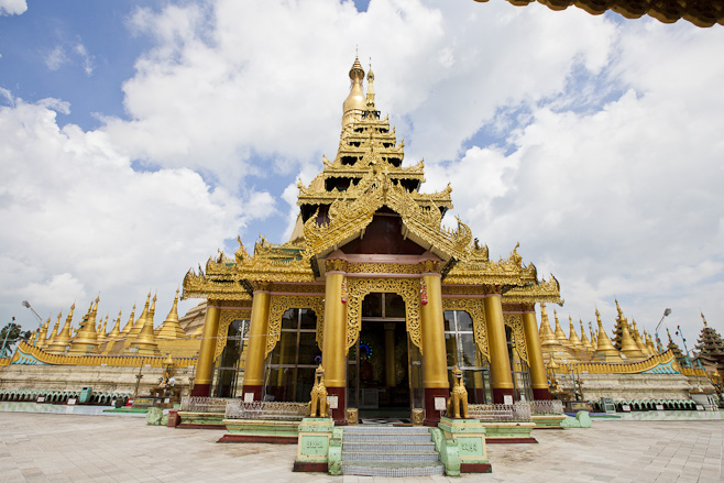
The Shwemawdaw Paya or Golden God Temple is a Mon temple originally built in the tenth century, but subsequently rebuilt several times – after major earthquakes. The current pagoda, at 375 feet, is the tallest in Myanmar; some 50 feet taller than Shwedagon.
The ornate entry to Shwemawdaw Temple, Bago, Myanmar.
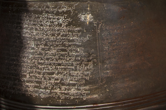
Burmese or Mon script on a Shwemawdaw Temple bell.
Women heading for prayers, Shwemawdaw Temple, Bago.
Colours and Textures: Small shrine area in Shwemawdaw Temple, Bago, Myanmar
The luminous marble and gold paint typical of Burmese Buddhas.
Touching the Earth Shwemawdaw Buddha
Astrology and Palmistry Shwemawdaw Fortune Teller
Faithful and hopeful have prayers written on papers in exchange for “donations”.
Three more Shwemawdaw Buddhas.
Shwemawdaw Steps
Not far from the Shwemawdaw Temple, another temple complex houses a 55 metre- (180 ft) long reclining buddha. The Shwethalyaung Buddha was built by King Migadippa I in 994. After Bago was destroyed, the buddha was lost under regrown vegetation for over a hundred years. After it was rediscovered in 1881, the undergrowth was cleared, and in 1906 a tazaung (pavilion) was built over it to protect it from the elements.
Up the steps to the Shwethalyaung Buddha…
Indigent’s bedroll: Shwethalyaung Temple steps.
At the feet of the 55 metre Shwethalyaung reclining Buddha.
Gilded and Jewelled: At the feet of the Shwethalyaung Buddha.
Shwethalyaung Buddha Head
Buddha resting on jewelled chests; a jewelled deva watching over.
Toddler with Fortunes
Shwethalyaung Buddha Feet
A teak seller shows her wares.
Carved Burmese teak ornaments for sale.
Another Gift Seller
Myanmar’s ethnic groups in doll form.
Gift seller in the Shwethalyaung Courtyard.
A postcard seller sends us off on our way…
We left Shwethalyaung for the two hour drive back to Yangon –
Breathtaking natural beauty: hot spring water splashing over travertine terraces. Mound Spring at Mammoth Hot Springs, Yellowstone National Park.
It’s pretty hard to beat nature.
And Yellowstone National Park, that amazing natural space covering 8,987 square kilometres (3,472 square miles) of water, grasslands and forest in Western USA, serves up some of nature’s best.
From the iconic spout of Old Faithful to the less visited but equally intriguing Artist’s Paint Pots, Yellowstone’s geothermic features are second to none.
The natural travertine terraces at Mammoth Hot Springs, however, must be the-best-of-the-best.
For our brief visit to Yellowstone Park in August, we stayed at Gardiner, just outside the north entrance to the park. From there it was a short (albeit slow) drive through the Roosevelt Arch to the park’s many attractions.
The North Entrance to Yellowstone is through the rustic town of Gardiner and the Roosevelt Arch, dedicated by (and to) President Theodore Roosevelt in 1903.
Although Yellowstone was established by an act of US Congress in 1872 under President Ulysses S. Grant, the 50-foot tall basalt arch which marks the most important entry into the park was named for President Theodore Roosevelt, conservationist and dedicated Mason, who laid the cornerstone of the structure in 1903.
Once into the park, the landscape changes dramatically. We kept our eyes on the mountains, and were rewarded with sight of a band of Big Horn Sheep: ewes, lambs and yearling males; barely visible as they clambered effortlessly over the rocks. Unfortunately, the older males, with their distinctive, large eponymous horns, were nowhere to be seen.
Almost invisible against the rock face, female and young Big Horn Sheep (Ovis canadensis) on Mount Everts.
Outlined by light, a Big Horn lamb looks to see where mum has gone.
Mammoth Hot Springs are only eight kilometres (5 miles) into the park from the Roosevelt Arch. We circled the busy car park for a while before gaining access to a newly-vacated space, grabbed the cameras and went for a walk along the boardwalks.
Liberty Cap, a 37-foot (11-m) dormant hotspring cone, sits at the northern edge of Mammoth Hot Springs. Built up of mineral deposits over hundreds of years, it was named for its resemblance to the peaked caps worn during the French Revolution.
Flowers on the Edge Wildflowers grow in the rippled waters of the lower terraces, Mammoth Hot Springs.
Devil’s Thumb, a rocky outcrop, and the travertine layers of Minerva Terrace, Mammoth Hot Springs.
The travertine terraces of Mammoth Hot Springs are like nothing I’d ever seen before. The underlying rock in this area is limestone. Fractures in this limestone allow hot spring waters, replenished by rains and snows, to bubble through to the surface, dissolving calcium carbonate en route and depositing it as travertine.
Hot blue waters and white limestone terraces comprise Minerva Terrace.
Primal Colours: thermophiles (heat-loving organisms) colour different parts of the travertine. Yellow and colourless thermophiles live in the hottest waters; the orange and brown indicate cooler waters.
Lacy white limestone travertine against yellow spring waters, Minerva Terrace
Terraced slopes in white and yellow: Minerva Terrace
Plants on the Edge Flowers in the hot spring flats – Mammoth Hot Springs.
Up to the Overlook Elevated walkways protect the sensitive landscape from the tourists – and the tourists from themselves. Every year, people who can’t resist leaving the boardwalks or testing the waters suffer from burns.
Steaming white travertine terraces, with yellow wildflowers at the border. New Blue Spring.
Reflective waters: Main Terrace, Mammoth Springs
Mountains – and mountains of limestone: Main Terrace, Mammoth Springs
Like a waterfall, the hot mineral waters tumble over the terraces of Mound Spring, Mammoth Springs.
Mound Spring
Mound Spring
Twilight, and the wapiti or elk (Cervus canadensis) come out to graze on the lawns around Mammoth Hot Springs.
Mammoth Hot Springs Drive-Bye
Thermal steam in the evening light on the Upper Terraces of Mammoth Hot Springs.
Angel Terrace, on the Upper Terraces of Mammoth Hot Springs.
Trees engulfed by travertine stand like sentinel skeletons against the evening light.
The evening light was falling as we drove around the Upper Terraces, so we pointed the car north for the short trip back to our accommodation.
End of another beautiful day – Yellowstone National Park
People are always ready to take a break and smile, unselfconsciously, for the outsider with a camera.
One of the many things I love about being in Asia, is people’s willingness to be photographed.
Personally, I don’t like having my picture taken. If I’m in the sights of a lens rather than looking through a viewfinder, I get tense and awkward – which results in a bad photograph; only proving, through a sort of circular logic, that I am not photogenic.
Because I don’t like being photographed, I’m very cautious about making pictures of other people. That is “making” – not “taking”. “Making” is a co-operative process; “taking” is intrusive and uncomfortable. I usually make a point of being sure I have implicit permission before pressing the shutter: this might mean fewer “candids”, but at least I feel I have been given the “rights” to the portraits I have.
A rickshaw driver at the top end of a Bago market street spots me with my camera, and smiles.
In Myanmar, as in many parts of Southeast Asia, street portraiture is relatively easy. So much of life is conducted out of doors in public spaces. People generally have little choice about this, as “homes” and “offices” can be small, dark and stifling hot. Because people are used to being in the public eye when conducting personal business, the concept of privacy is different. Being photographed is less of an intrusion than it might be in other places.
Take the following photograph, for example. I don’t know if the man in the maroon longhi and crisp white shirt is a lawyer, an advocate, or a regional head-man, but he was clearly in consultation with the man in the bamboo hat. They were discussing, at length, an issue of much importance to the man in the hat, in the impromptu “office” at the top of the steps.
The office on the steps: a villager tells his problem to a head-man who makes notes of the story.
I waited until they reached a pause in their transaction before moving closer for a portrait, but, with life’s unhurried pace here, I don’t think they would have minded being interrupted. The “respectful distance” I had kept was more about my sensibilities than theirs.
With his story told, the beetle-chewing villager is now relaxed and happy.
I love following the life of the village into the markets.
The thanakha seller sits tall in front of her stand of Thanakha or Elephant-Apple Tree pieces.
The younger woman at the stand next door was keener to engage with the stranger. She showed me how to grind the bark, mix it with water, and apply it in the protective facial-paste many Burmese still wear.
The Bago market is a boon for local market gardeners, with seeds of all descriptions.
Seed-sellers in the market. This region is ethnically diverse: Burmese Indians are common here.
– as are ethnic Karen (or Kayin) people. Karen shopkeeper in typical hand-woven cotton head scarf.
A small child shops with mum –
– while another watches the street from the shopfront with Grandpa.
On a street corner, a motorcycle driver offers me a lift…
… but settles for a picture.
It’s lunch time, and a woman takes a break from chatting with her neighbour, to offer me some of her rice.
Three young Burmese men on a bike stopped for a portrait before roaring off down the dusty road.
Back on the main street, a young boy watches me solemnly from a dark shop.
And, as I prepare to climb into my air-conditioned bus, a group of Burmese women are piled in a local transport for their hot, dusty ride home.
If I carried a reflector and posed people, or moved them into better light, I guess I would spend less time post-processing. I know photographers who do set up their shots – and there is nothing wrong with that – but I am too self-conscious, or too “British” and worried about imposing, or too impatient…
Besides, I like environmental portraits, that tell us a little about people’s lives. So, while my results can be patchy, they are realistic. The beauty of Asia is that the people are very tolerant of outsiders, so there is plenty of opportunity for practice!
[…] markets are a rich source of photographic – especially portrait – material (e.g. Portraits ~ Bago Local Market and The People of Shwezigon Pagoda, […]ReplyCancel
Can you get more Irish than Dún Chaoin (Dunquin) and An Daingean (Dingle), on the Corca Dhuibhne (“Seed or tribe of Duibhne”; the Dingle Peninsula) on the southwestern-most reaches of Ireland’s County Kerry?
I very much doubt it!
After staggering into Dingle from Annascaul, wet and windblown, we were pleased to have two nights in one place and an official “rest day” on our walk around the Dingle Peninsula.
Dingle is delightful. We ate fish and chips and mushy peas while the football played on the TVs one evening. The next night, as we were listening to an old and expert fiddle player, we and our tables were pushed back to make space for the dancers. Not the Irish Dancers we know from television: those unsmiling girls in short kilts whose legs stomp and twist while their arms never move. No, these were four pairs of everyday-looking people who turned into whirling dervishes once the fiddler took up his bow: swirling and spinning around in patterns so fast and complex my head spun just watching them.
Pretty, even in a drizzle and under gray skies; Dingle, Co. Kerry.
National Geographic once called Dingle ‘the most beautiful place on earth’. Even in the morning drizzle, with gray skies overhead, it is a pretty town.
Of course, I was loath to waste our day in Dingle “resting”, so we caught a lift to Dunquin to catch a boat to the Blasket Islands – or so we had hoped. With the rough weather, the boats weren’t making the crossing, and we settled for a few interesting hours in the Great Blasket Centre instead.
An exhibition of photographs of the residents and houses, etc, from Great Blasket Island.
The unnamed statue that I like to call “Against the Wind” evokes the feeling of hardship on the island.
It looks calm enough today – Great Blasket Island, off the southwest coast of Ireland.
This whole area is Gaeltacht – the Irish language word meaning an Irish-speaking region – and Great Blasket Island was the language cradle that allowed this to happen. By the end of British rule in Ireland (1920-22), Irish Gaelic was spoken by less than 15% of the population. Great Blasket Island (An Blascaod Mór), however, sitting off the coast, with no modern conveniences, no priests, pubs, or doctors, was fairly isolated, allowing the old language to survive and thrive. The small community (160 people at most) that lived there until the final evacuation in 1953, had rich oral traditions, which they were encouraged to write down after visits by Irish scholars and poets in the early twentieth century. This led to a remarkable number of writers who published works in Irish; many of which have been translated into other languages. Spoiled for choice in the Visitor’s gift shop, we settled on “Twenty Years a-Growing” by Muiris Ó Súilleabháin (Maurice O’Sullivan), first published in 1933, and read by me with a smile on my face.
Once finished at the centre, we booked a cab to meet us later at a local pottery workshop, and set off walking across the roads and hills.
Wind-swept and isolated – the houses of Dunquin, Co. Kerry.
Looking back down the quiet roads…
Tiny flowers grow in the stone walls along the roadway.
House on a hill.
Curious, we followed the bus-loads of tourists up the stony hills at Clogher Head.
We were greeted by large granite rocks –
– and treated to a fabulous view! The little beach of Clogher Strand, Ferriter’s Cove and, in the distance, the peaks of The Three Sisters.
Flowers on the Edge
Like something out of the “Irish Spring” commercials of my youth, a woman – dwarfed by the landscape – runs down the hill…
Cape, Cove and Cave: The beach at Clogher Strand, Ferriter’s Cove and, the mountains the distance.
Daisies growing wild. Ballyferriter, Co. Kerry
Standing stone with a viewing hole –
– lined up with another stone with another viewing hole.
Some properties have a killer view!
Strange creatures greet us as we finally reach the Louis Mulcahy Pottery complex in Clogher –
– while other works, like the beautiful pieces for sale inside the shop, are the epitome of stylish grace.
Back in Dingle, the afternoon sun shines long enough for us to get from one shop to another.
Ceramic babies in the shops are ready for the extremes of local weather.
Young women take advantage of the sun to get their hair decorated…
… and women walk home with their shopping.
Back in Dingle, during intermittent rain showers, we browsed in shops displaying local pottery, woven and knitted goods, jewellery, musical recordings and instruments. When the sun came out, we enjoyed locally made ice cream. Everywhere, we heard people speaking Irish Gaelic between themselves, before switching to English to speak to us.
Modern expressions of age-old crafts, language and music are alive and well here, and it was a joy to partake – even if only for a day.
Ursula, thank you for this report. photos of a really beautiful landscape and the ceramic babies are lovely. I wish you a pretty weekend, DietmutReplyCancel
[…] by bus, and then from Camp by foot. We had spent days trudging through rains, down country lanes, into museums and shops and churches, over hills and through bogs, over mountains and across beaches. We were sore and […]ReplyCancel
Energy, the costs of energy, and the real costs of renewable energy are hot topics in our house and our neighbourhood at the moment. In Australia, black coal has traditionally accounted for more than half the country’s energy production. For almost 20 years, I’ve been paying extra on my electricity bills to help promote the development of renewable energy; seemingly to very little effect, as only 1.7% of total production (2009 figures) is from renewable sources. In 2010, the Australian government introduced schemes – large and small – aimed at increasing the proportion of renewable energy to 20% by 2020.
Good idea, surely: but it opened the floodgates for some poorly thought-through but well intentioned plans; some enterprising profiteering; and some outright scams. Our townhouse benefited from government-subsidised ceiling insulation, so when our hot-water heater exploded, we were ineligible for a rebate on the solar hot water that we installed. It would seem that all the current “sales” on domestic solar roof-panels stop just short of our small town, so the ones we are installing will take years to pay for. All part of the cost of sustainable energy…
For the sake of putting my money where my mouth is, I’m prepared to foot these bills. Some costs, however, are too high.
Late last year we attended a local public meeting in Eden, Australia, to discuss the proposed seven-turbine wind farm on the headlands of Twofold Bay. Opponents risked being called “NIMBYs” (Not in My Back Yard!) and worse, because wind energy, the fastest growing renewable energy sector worldwide, is virtually pollution-free and one of the lowest-priced renewable energy sources. However, location is everything, and as long as we still have options, detracting from beautiful coastal views by building turbines three-times the height of Boyd’s Tower on Red Point seems insane.
Canada has always generated a significant part of its electricity from hydroelectric dams: many built before the environmental costs to local ecosystems were assessed in quite the same way as they would be today. I always took hydropower for granted; we used to boat and fish in the lakes created by dams, and I remember visiting a power plant in the Rocky Mountains as a child. Of course, now I am more aware of the huge impacts of new dam projects on down-stream watercourses, and the communities and wildlife that depend on them.
But, we have been consuming energy for a long time and we have to get our power from somewhere.
While I was in British Columbia (BC) last July, I was intrigued by the opportunity to visit a hundred-year-old powerhouse at Stave Falls; once BC’s principle source of hydroelectric power. So, my husband and I borrowed a couple of children and set off for an afternoons’ exploration.
The Stave Falls Powerhouse, originally built in 1912, now operates as a museum/educational facility.
The museum houses memorabilia from the early days of the Powerhouse’s conception and construction…
… examples of local flora and fauna…
… and hands-on displays.
Looking down over the generator hall, with the turbines and generators installed in 1912.
Remember this?
Generator – circa 1912.
Alternating ammeter ~ of course!
The power station’s original penstocks: floodgates controlling intake to the turbines.
Rusty pipes: original penstocks.
Original turbine.
Hundred-year old switches.
More old switches.
Almost abstract: Ancient electrical bits and pieces.
Almost abstract: metal parts.
“Next to Sunlight” Electricity ads through the ages.
Electricity meters.
Old electrical machinery.
Watt meters and time keepers.
Downstream from the dam: the MV Shirley, a tug used on the reservoirs to gather up timber and debris.
Original glass insulators.
Blasting spike in the rock wall.
At the entry/exit there is a crossing to the upstream side.
Keep out of the dam!
The extensive waters of Stave Lake lie beyond… where the newer Alouette-Stave-Ruskin generation system is harnessing electricity further upstream.
The world has changed so much in the hundred years since this power station was first opened – electricity is such a part of our lives that world consumption of exajoules per annum is more than ten times what it was back then. On average, each of us is consuming more than two and half times what individuals used in 1912.
As long as we keep using it, we have to come up with ways of producing it – and minimal-impact, renewable sources like waves and water, sun and wind, do seem like the only viable options.
I wonder what it will all look like in another hundred years?
Great Post Ursula, what was the outcome for Ben Boyd Point. I happen to think Windfarms are beautiful, serene and practical but some places of significance such as Ben Boyd need to be considered very carefully. thanks for the shareReplyCancel
Hi Signe!
I can’t find any late updates on our local wind farm – I don’t know if the proposal finally died, or if it is still sitting on a government approval desk. Fingers crossed!!
I, too, think wind farms are beautiful: in the dry hills of a prairie landscape (eg. California and other western US states); out behind grazing lands and an occasional lake (eg. Lake George, NSW); in short, in large spaces where people don’t have the need or desire to get too close!ReplyCancel
- Performing the Ganga Aarti from Dasaswamedh Ghat, Varanasi
- Buddha Head from Shwedagon Pagoda, Myanmar
- Harry Clarke Window from Dingle, Ireland
- Novice Monk Shwe Yan Pyay Monastery, Myanmar
Packets of 10 for $AU50.
Or - pick any photo from my Flickr or Wanders blog photos.


 As long as we keep using it, we have to come up with ways of producing it – and minimal-impact, renewable sources like waves and water, sun and wind, do seem like the only viable options.


")

Golden temple & one large reclining Buddha. typical life around the temple. Very nice.
Can’t even imagine what it must be like to stand amongst such history… jsut beautiful
Thanks, Signe and Gabe! Indeed, it is a privilege standing amidst the history. 🙂