 Seattle Reflections
Symbols of a hip and modern city: The Space Needle shines in the polished metal sides of the funky Experience Music Project Museum. Every city has a “past”.
Even an eclectic and worldly city like Seattle – the home of grunge and Dr. Frasier Crane; Microsoft and Starbucks Coffee – has a rough and colourful story. Scratch the surface of the modern architecture and you will find a wild pioneer history, traces of which survive beneath the modern city streets.
Literally!
For, as it turns out, Seattle was originally ten feet lower than it is today.
We learned this, and much more, when we went on a “Bill Speidel’s Underground Tour” last month. We started our guided walk in a restored 1890’s saloon that once belonged to David Swinson “Doc” Maynard, one of the city’s more open-minded forefathers.
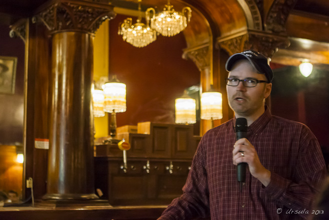 Our Guide to the Underground
Our tour began inside a restored version of Doc Maynard’s Public House. We then passed through Pioneer Square, where a bust of Chief Seattle stands as a reminder of the original peoples of Washington State, the First Nations of the Suquamish and Duwamish tribes.
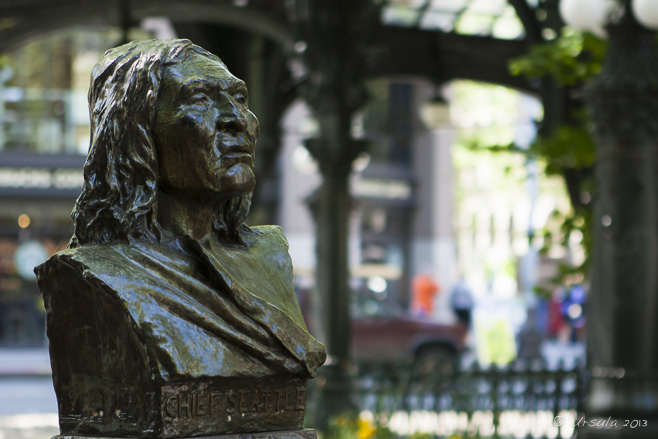 Chief Seattle (1790-1866)
Seattle (the most common transliteration of his name) was chief of the Dkhw’Duw’Absh and Suquamish people at the time of first European settlement.  The Keys to the Underground
Our guide briefs us before opening up the the doors to the underground. Old Seattle
The old town was built of wood – and very close to sea level. Seattle can date it’s European settlement back to 1851-1852, when a number of competing interests, most notably the very pious pioneer brothers Arthur and David Denny, entrepreneurial mill owner Henry Yesler, and the generous and fun-loving doctor and water-front developer “Doc” Maynard, developed vast tracts of land.
The burgeoning town relied on the shipping and timber industries. Prostitution, liquor, and gambling in the freebooting and relatively lawless waterfront area ensured that workers had somewhere to spend their free time and money.
Under the City
The rough walls of the original Seattle; now underground. A key player in Seattle’s underground history is modern plumbing.
“The town’s proximity to sea level caused a new problem, literally, to rise up. In 1851, the same year the Denny party arrived, a fancy new device was introduced at the White House. It was called a “water closet,” and, boy, did these things take off in popularity. Even in the tiny frontier town of Seattle, indoor toilets became the rage.”
Locally known as “crappers”, after the British plumber Thomas Crapper, who modernised indoor plumbing and bathroom fittings, and was, by Royal Warrant, plumber to British kings, toilets were everywhere. Twice a day, with the incoming tides, crappers all over the young city would back up.
Not a pretty thought!
Old “Crapper”
A bathroom from the 1800’s remains exposed in the underground rooms. 111 Yesler
Underground street signs correspond to those above; Yesler’s name is everywhere in Seattle. Through the Streets
People on elevated walkways, above the cracked old streets and under the busy new streets. The Great Seattle Fire of June 6, 1889, which started when a carpenter’s apprentice let his glue pot boil over, and which didn’t finish until more than 25 blocks of mostly wooden buildings had been razed, gave the city a new lease on life. The fire made international news, and relief money poured in, allowing the city to rebuild: in stone and brick, rather than wood, this time.
To deal with (or bypass) the problem of soggy lands and dodgy plumbing, the city built retaining walls, eight feet or higher, on either side of the old streets, filled the spaces between them, and paved over the fill, making the streets one story higher than the old sidewalks that still ran alongside them. Sensibly, people started conducting most of their business on the second floor of their buildings, and new sidewalks soon bridged the gaps between the elevated roads and the buildings, creating the tunnels that form part of today’s underground.
On the Sunny Side of the Street
We emerge from the underground briefly… Sidewalk Skylights
… to have a quick look at the sidewalks.. Under the Skylights
… before descending again to see what they look like from below. Skylights
It is surprising how much light there is where the skylights have been left in place. Bank Vault
We follow our guide through what was once the vaults of the street-level bank, and is now “haunted” underground space. Iron Tub
All kinds of things are left behind in the various rooms, which belong to the property owners above. Pipes and Plumbing
Utilities still live under the businesses and sidewalks. Tin Mouldings
To built quickly and cheaply, tin mouldings, made to look like stone carvings, decorated buildings. Lumber-Jack’s Boots
In the museum and Underground Tour gift shop, various memorabilia of Seattle’s origins, can be seen. Lavatory Mists
Seattle had to develop ways of dealing with it’s fickle plumbing system! Beautiful Crapper
The pièce de résistance: an original porcelain Crapper toilet imported from England! In the early 1900’s the tunnels were sealed off (for fears of plague) and virtually forgotten, until they were rediscovered and reopened in the 1950’s and turned into a popular tourist attraction.
 It’s amazing what you find when you look under the façade of a modern city. It’s amazing what you find when you look under the façade of a modern city.
Happy travels!
Photos: 11May2013
Posted in Architecture,History,USATags: architecture,blog,history,Photo Blog,travel,Travel Blog,urban,Ursula Wall,USA,walk
Buddha Head
So shiny, you can almost see yourself! U Min Thonze Cave, Sagaing Hills Buddhist temples in Myanmar are clearly loved and well cared for. Offerings of gold, flowers, and incense are everywhere, and the walls and floors are so shiny you can see yourself reflected in them: often the product of donated labour.
Mahamuni Temple, Mandalay, and Soon U Ponya Shin Pagoda, in the nearby Sagaing Hills, which I visited one day in September last year with photographer Karl Grobl, guide Mr MM, and a group of other photo enthusiasts, are two cases in point.
When travelling to new places, it is tempting to rush around and see as much as possible, but I was so taken by the shiny floors in the corridors of Mahamuni Temple (Pagoda), that I stood in a corner for a while, just watching people pass over them.
Mahamuni Temple
Shiny Floors and Golden Arches Reflections
Coming and Goings Elder Monk
When you stand still in a Burmese temple, people come and talk to you. This elder monk wanted to know what I thought of “the Lady” (Aung San Suu Kyi), and asked me to write my opinions in his notebook. Woman with Flowers Woman in Blue Mahamuni Temple is a major pilgrimage site because of its revered Buddha image, the Maha Myat Muni (or Mahamuni) Buddha. According to legend, the Mahamuni, or “Great Sage”, is one of only five likenesses of the Buddha made during his lifetime. (Archaeologists, however, date the image at around 150 AD, 600 years after the Buddha’s death.) The 4-meter high, 6.5-ton, bronze image is seated on a 1.84-metre high pedestal in a small chamber, and crowned in gold, decorated with diamonds, rubies and sapphires. Every morning at 4:30, monks wash its face and brush its teeth with care.
Gold leaves (like those pounded out at the King Galon Gold Leaf Workshop) are applied to the face and body of the Mahamuni Buddha by male devotees daily. So much leaf has been applied over the generations that the shape of the Buddha has become lumpy and distorted, with the gold as much as 15 cm thick in places.
Maha Myat Muni Buddha Image
Women are not allowed in the chamber, and must pay homage to the image from further away; this was as close as I could get. Silhouettes in the Corridors Reflecting, Single File Mahamuni Grandma
Pilgrims, or the homeless, can find a shiny clean corner of the temple to make their temporary base. Shoe Woman
The light of the temple is reflected in the eyes and the laughter of the people who work there; these people look after the shoes at the entry. Late afternoon of the same day, our little group visited the beautiful U Min Thonze Cave and the nearby Soon U Ponya Shin Pagoda, possibly the most important of the many pagodas, temples and monasteries that dot the Sagaing Hills.
Circle of Buddhas
Fourty-five porcelain Buddhas curve around the walkway in the U Min Thonze Cave. Curving Corridor
U Min Thonze Cave shines: from the light streaming in the arched doorways to the reflective tile floors and the gleaming Buddhas surrounded by mosaics of shimmering glass. Reverie
Reflective surfaces are everywhere in U Min Thonze Cave, creating a dreamlike atmosphere. Prayers
Burmese come to the Soon U Ponya Shin Pagoda to pay respects and pray to the Buddha. Smiling Down
The Buddha at Soon U Ponya Shin Pagoda gleams. Courtyard
The patterned tiled floors at Soon U Ponya Shin Pagoda reflect in the afternoon sun. Decorative Grill
A delicate grill screens off part of the temple grounds. Look Up!
A porcelain lion protects the golden chedi at Soon U Ponyashin Pagoda. Waiting for Customers
Reflected in the bright floor, a man waits for people to use his telescopes. Soon U Ponya Shin Pagoda sits at the top of the Nga-pha (Frog) Hill, and, even without the telescopes available, visitors get wonderful views over the Irrawaddy (or Ayeyarwady/Ayeyarwaddy) River and the temple-dotted Sagaing Hills.
The Ava (Innwa) Bridge
View over the temples of the Sagaing Hills and the Irrawaddy River. Pagodas Large and Small
View from Soon U Ponya Shin Pagoda over Sagaing to the hazy Irrawaddy delta. Monk on Pilgrimage Golden Chedi Roofs Goods for Sale
At every temple, there are goods for sale; a novice and his friend have a browse.
It is easy to feel uplifted in such beautiful places where people’s devotion to their religion is so palpably expressed.
Truly places that allow for reflection.
Mettā!
Pictures: 14September2012
Posted in Architecture,Myanmar,Religious Practice,TravelTags: architecture,blog,buddhism,buddhist,Myanmar,Photo Blog,religion,sculpture,temple,travel,Travel Blog,Ursula Wall,worship
Snow Gums
Leaning, spreading, snow gums provide a modicum of shade over the car park at Rennix Gap. One of the many beauties of Kosciuszko National Park in Australia’s alpine Snowy Mountains, is the assortment of walking trails. This makes it easy to find a walk to suit the weather, one’s mood, and the abilities of any walking companions.
The 6.5 kilometre walk from Rennix Gap to a Snowy Hydro radio repeater station, high on a ridge, is not a track I follow often. Although it is a pleasant 4-5 hour walk out and back, there are some moderately challenging inclines, and the lower areas can be very boggy and wet. When I have guests, I usually pick an easier walk or one with more dramatic views.
Having said that, the Rennix Walk is the first place I ever spotted the vibrant flame robin, or saw an echidna in the wild, and the track winds through some very pretty landscape. It was a sunny afternoon in early November – that is: late spring in the antipodes – the last time my husband and I decided to make the trek.
Rennix Walk follows an old management trail and starts by crossing grassy flats. You need to stay on the track: the ground is boggy and wet – especially after the snow melts of spring. Got the essentials? Hat, sunscreen, water, bug spray, and we might want the walking sticks on the hills. Sawpit Creek winds its way through the boggy plain. The trail climbs up through bush and snow gums and past giant granite boulders. The “bridge” over Stewarts Creek comprises some well-weathered boards. From Lakes Creek Saddle there are views across the wetlands to Kosciuszko’s Main Range. The alpine plants and snow grasses spring to life in the ground water soaking down from the surrounding hills. The bark of the stately snow gums is always a work of natural abstract art. Fallen trees are part of the cycle of the landscape. The Reddish Bog Heath (epacris glacialis) [I think?] has just started blooming. The walk rises up and crosses gorse-filled clearings. The Leafy Bossiaea (bossiaea foliosa) [I think?] has also started to flower. I have no idea what the growth at the base of this tree trunk is, but it made for some interesting textures. The top of Giants Castle affords great views, but the ascent is only recommended for experienced climbers. From a safer rocky vantage point, there are nice views of Lake Jindabyne, far below. The landscape in the other direction stretches out over the Snowy River and up to the Main Range. The next granite outcrop, which to me looks like a pair of rabbits, signals that we are close to the apex. The top of the walk is marked by a rather un-photogenic repeater station, which sits atop more granite boulders. Again, the climb can be a little challenging, so we opted for a short sit and a muesli bar before returning back the way we had come.
Snow Daisies (brachyscome nivalis) are scattered across the ground. Alpine Rusty-Pods (hovea montana) stand out against the alpine grasses. Once we are back at Lakes Creek Saddle, we know it is all a gentle walk downhill. White Purslane (neopaxia australasica) dots the granite-strewn path as we head back to the car.  Rennix Gap was named for W.E. Rennix, an engineer and surveyor who died after being caught in a blizzard in the area. We were much more fortunate: I lost (and found) my mobile phone, the boggy ground took its toll on the soles of my favourite old hiking boots, and we returned to the car a little wet and worn out. Rennix Gap was named for W.E. Rennix, an engineer and surveyor who died after being caught in a blizzard in the area. We were much more fortunate: I lost (and found) my mobile phone, the boggy ground took its toll on the soles of my favourite old hiking boots, and we returned to the car a little wet and worn out.
In short, it was an enjoyable afternoon, and we were able to bask in self satisfaction as we clinked our glasses over dinner that evening.
To your health!
Pictures: 11November2012
Posted in Australia,Nature,TravelTags: alpine,blog,flowers,Kosciuszko,National Park,nature,Photo Blog,Rennix Walk,travel,Travel Blog,Ursula Wall,walk
Sacagawea and Baby Jean Baptist
Sculpture by Glenna Goodacre (b. 1931), Buffalo Bill Historical Center, Cody, WY The Wild West is a place of legends and stories…
Few are more moving than that of Sacagawea (Bird Woman), the Lemhi Shoshone woman, kidnapped in 1800 by a raiding party of Hidatsa when she was about 12, and a year later, given or sold, along with another young captive Shoshone girl, to Toussaint Charbonneau, a French Canadian trapper. Thirty-four year old Charbonneau was hardly a prime catch: six years earlier he had been stabbed by an old Saultier woman for raping her daughter.
In 1804, Lewis and Clark hired Charbonneau as an interpreter for their expedition to explore the Western United States, because Shoshone-speaking Sacagawea was part of the deal. She gave birth to her first child, Jean Baptist, February 11, 1805, before the expedition set off, and the child travelled with her across the country. “Meriwether Lewis called [Charbonneau] “a man of no peculiar merit”.” Sacagawea, on the other hand, so impressed Lewis and Clark when she rescued their journals, records and other materials from the Missouri River after a boat capsized, that they named the Sacagawea River in her honour.
In American popular history, Sacagawea is an integral part of the Lewis and Clark story: in the early twentieth century, the National American Woman Suffrage Association adopted her as a symbol of women’s worth and independence; in 2000, the United States Mint issued the Sacagawea dollar coin in her honour; and in 2001, then-president Bill Clinton gave her the title of Honorary Sergeant, Regular Army.
I suppose if I were an American, I’d have know more about Sacagawea before visiting Wyoming – in the Wild West, the place of legends and stories…
Watch for Fallen Rock
The road out of Yellowstone National Park and into the rest of Wyoming lead us through a magnificent rocky landscape. Like a scene out of a Western movie, rocky outcrops overwhelm the road. We have arrived in frontier country. We found a motel in Cody, Wyoming, and parked our little sedan next to the Harley Davidson motorcycles and Mack trucks in the car park. Taking the desk clerk’s advice on eateries, we headed down the road to Cassie’s Roadhouse, a typically western-looking bar with a cowboy on a bucking bronco in neon over the front door… and a huge parrot on the sign over the drive-in entry.
Here we learned about another woman who managed to succeed against the odds. Cassie Welsh moved to Cody with her father and married a local engineer in 1907. He died shortly thereafter, so she opened a “Ladies of the Night” house in central Cody. She later moved to the current Roadhouse on the West Strip, where she owned and ran the genteely-named Cassie’s Supper Club until her death in 1952. She is fondly remembered locally as “a lovely lady who always helped people”.
The parrot became a trademark of the next owners, who had brought two live birds from Brazil – as one does.
The restaurant was full when we arrived, and rather than wait we decided to sit in the bar, next to the wooden dance floor where two couples were about to practice. I thought we might be up for some line-dancing or a country two-step, but no! On Tuesdays, the local dance champion and instructor gives free lessons; next thing we knew, we were brushing up our cha cha. In Wild West Cody!
It was far too much fun, and we never made it to the city’s nightly rodeo.
The next morning, we allocated some time to visit the Buffalo Bill Historical Center.
Not enough time, as it turns out. It is for good reason that the entry ticket is valid for two days: the complex of five museums in one building has been described by The New York Times as “among the nation’s most remarkable museums.” (Edward Rothstein, New York Times, August 3, 2012).
Grizzly Bear
We entered the Buffalo Bill Historical Center through the Draper Museum of Natural History which depicts various aspects of the Greater Yellowstone area. We found it fascinating after having just been in the National Park itself. Enter the ultimate Wild West legend: Buffalo Bill Cody, a name synonymous with the history of the American West.
He was born William Frederick Cody in 1846, of Quaker parents. From 1853, his family lived in Kansas, where they were regularly persecuted for their outspoken anti-slavery stance. When Cody was 11, he became the main breadwinner after his father died of complications from injuries inflicted by a pro-slavery supporter. He worked, first as a “boy extra” – a message runner – for a freight carrier, then as a scout during the Utah War, where he gained his reputation as a an “Indian fighter”.
Cody’s colourful career is a mix of fact and “spin”. He earned his “Buffalo Bill” nickname by killing 4,280 American Bison in only 18 months (1867–1868) while he was contracted to the Kansas Pacific Railroad to supply them with meat for their workers. Not long after, Ned Buntline’s serialised stories and dime-novels turned a loosely fictionalised version of “Buffalo Bill” into a national folk hero.
By age 26, Cody had been awarded a Medal of Honor for “gallantry in action” while serving as a civilian scout. The same year, he made his stage debut in The Scouts of the Prairie, one of Buntline’s original Wild West shows. During the 1873–1874 season, “Wild Bill” Hickok joined Cody and “Texas” Omohundro in a new play called Scouts of the Plains.
Ten years later Cody founded his own “Buffalo Bill’s Wild West” show, which was staged, in one form or another, across the US and in Europe until 1908. Looking through the exhibits and memorabilia, I was amazed at the breadth and depth of performers he engaged. Fancy riders from all over the world; Western figures whose names I recognised, like Calamity Jane and Annie Oakley; Native Americans like Sitting Bull. Buffalo Bill’s troupe was successful at popularising “The West” in the US and Europe, making his persona an American icon and an international celebrity.
Like other figures who are larger than life, Cody’s legacy is a mixed one. Although responsible for thousands of buffalo deaths, he actively supported conservation, spoke out against hide-hunting, and pushed for a regulated hunting season. He was known as an “Indian fighter” but he respected Native Americans and their rights. He is quoted as saying: “Every Indian outbreak that I have ever known has resulted from broken promises and broken treaties by the government.” He was castigated as a drunkard, a fraud, a bad businessman and a racist. But while he made and lost fortunes, he was generous to a fault. He supported women’s rights and payed them, and the Native Americans and foreign nationals in his traveling show, according to merit, not race or gender.
He died in 1917, a Western legend – but almost broke.
The city of Cody, and it’s wonderful museum, is only a small part of his contribution to the American West.
Scout’s Gear
Long hair, to protect the eyes and ears; long coat for warmth; and long rifles for more accurate, powerful shots at enemy or game. Hon. W.F. Cody Uniform and Saddle “The Buffalo Bill Combination”
Western showmanship: Props from one of Buffalo Bill’s shows. Annie Oakley’s Gloves
Costume from one of “Buffalo Bill’s Wild West” shows. Luxury Tenting
View inside an American Army Scout’s base-camp tent, Buffalo Bill Historical Center. Portable Tent
Smaller tents were used for scouting forays. Cody called Native Americans: “the former foe, present friend, the American”.
The Plains Indian Museum section of the Buffalo Bill Historical Center depicts the history and culture of Native Americans, while highlighting their place in modern America.
Dog Soldier Feather Bonnet
Visitors examine the exhibits in the Plains Indian Museum section of the Buffalo Bill Historical Center. Plains Indian Tent Ancient “New World” Corns Beaded Papoose Carriers Woman’s Work
A Plains woman on horseback, with a travois. Cowrie-Shell Embellished Dress
Quill working, hide painting and bead working demonstrated women’s skills, and their pride and love for their families. Man’s Cape Fury ~ Man and Horse Buffalo Bill
The sculpture of a very dapper Bill Cody outside the Buffalo Bill Historical Center bids us good-bye. Wolf Howling
Another enduring symbol of the American West… Reluctantly, after a great lunch in the cafeteria, we set off, out of the Buffalo Bill Historical Center, out of Cody, and east – out of Wyoming…
Wyoming Prairies and Mesa Highway I-14 East Shell Creek
The low point, before the rise into the Bighorn Mountains. Into a Snow Cloud
The road through the Bighorn Mountains disappears… Middle of summer, but they say it’s going to snow tonight! We stopped at a forlorn off-season mountain resort before descending the other side of the Bighorn Mountains. When we finally managed to attract some service, our waitress rued the “miserable climate” and the likelihood of summer snow. She was fed-up, homesick and California dreaming…
The Wild West is not for everyone.
‘Till next time!
Pictures: 15August2012
Posted in America,Biography,History,LandscapesTags: America,arts and crafts,blog,Buffalo Bill,Buffalo Bill Historical Center,First Nation,history,museum,Native American,nature,people,Photo Blog,Plains Indian,sculpture,travel,Travel Blog,Ursula Wall
Castlegregory Beach
One of Ireland’s longest beaches: from Cloghane Village to the Maharees and Castlegregory. Rain.
It was day nine of our walk around the Dingle Peninsula last June, and once again we woke up to rain.
Soft, misty, Irish rain – but coat-soaking, bone-chilling, camera-splattering rain even so. Not my idea of beach weather! My walking boots were still wet from crossing bogs the day before, so the overcast skies had me feeling less than cheerful.
According to our trip notes, we were up for a 29 kilometre walk, with 11 kilometres of it (or 11 miles – depending on whom you believe) along Castlegregory Beach. In the rain.
Day 9: Cloghane to Castlegregory
A long but not a demanding day, dominated by Irelands longest beach, with fantastic views of both sea and mountains and the off shore Maharees Islands.
Local birds include seabirds (several species of seagull, shags, cormorants, gannets to name but a few), larks, starlings, curlews, crows, ravens, garden birds such as sparrows, robins and finches, and wading birds such as the heron. The swallow is a frequent visitor in the summer months, all to be seen on this walk.
Distance: 29 km/18 miles, Ascent: 40m/120 ft
River Owenmore
Everything was fresh – and wet – as we set out on our walk from Cloghane, Ireland. Castlegregory Beach
One small patch of blue beckons us as we start our traverse along the beach skirting Brandon Bay. Textures
Wind whips up the wet sand over the creatures stranded by the last high tide. Castlegregory Beach
Two hours into our walk, the skies start to clear, lifting our moods, and completely changing the colour of the landscape. Gull Taking Off Seagulls Wading
Large European Herring Gulls (Larus argentatus) congregated in groups at the water’s edge. Seagull in Flight Seagulls in the Surf
A Lesser Black-backed Gull (Larus fuscus) wades at the water’s edge. Sand Dunes
A lot of our walk was past dunes covered in hardy marram grass. A Tuft of Grass
European Marram Grass or Beachgrass (Ammophila arenaria) clings to the windy sand-scape. Nature’s Still-Life: Pebble Drift As we approach the north end of the beach, black clouds roll in … … slanting the light low over the dunes … Windsurfer
… and darkening the skies over the hamlet of Fahamore (An Faiche Mór or “the large green”). Oystercatchers
Eurasian Oystercatchers (Haematopus ostralegus) are meant to be common in this area; these were the first we saw. Body Surfers
Young people in their wetsuits seem unconcerned about the incoming clouds. Once we reached the little hamlet of Fahamore (An Faiche Mór) at the north end of Brandon Bay, we took a break at the charming – and apparently “famous” – Spillane’s Bar & Restaurant. We were more than ready for a late lunch and early libation: there is nothing like a little stroll in the sea air to sharpen the appetite!
The next stretch of walking took us across Scraggane Bay, then back south along Tralee Bay towards Castlegregory.
Pied Wagtail (Motacilla alba yarrellii) Boats on Scraggane Bay
A small fleet of fishing boats, netting European lobster, spiny lobster or crayfish, spider crab, edible crab, and Atlantic salmon, keeps this area alive. Rusty Cart
The other economic mainstay is farming: mostly root vegetables, which love the sandy soil. A young bull watches us pass. Like a Commercial!
It must be dinner time: the horse seems to be racing the car across the Maharees Peninsula. Kilshannig Graveyard
The crumbling graveyard at Kilshannig includes an ancient (seventh century) cross slab. Rocky Coast
The beach on the east of the Maharees Peninsula, along Tralee Bay, is covered in sharp rocks. Fish Traps
Traps for lobster or crayfish are scattered around Tralee Bay.
The overcast had lowered again and the skies were almost dark by the time we stumbled into Castlegregory, our home for the night.
It had been, as our trip-notes had promised, a “long but not a demanding day”: a wonderful walk with some great scenery.
So, I was happy: my camera chips were full… and my boots were finally dry.
Sláinte!
Pictures: 27June2012
Posted in Ireland,Landscapes,Nature,TravelTags: beach,blog,boats,Dingle Peninsula,Ireland,nature,Photo Blog,rural,The Dingle Way,travel,Travel Blog,Ursula Wall,walk
« Older posts
Newer posts »
|


")
