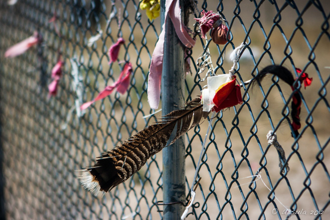
 Catching Dreams
Ribbons and feathers for loved ones wave on the wind on the graveyard fence, Wounded Knee, SD We drove across North Dakota on our road trip this summer: about 350 miles – almost all of them dead straight – through black dirt and green hills, and under a dark, looming sky.
It made me think about our visit to neighbouring South Dakota last year.
Granted, the landscape further south was different: hotter, drier, with more buttes and badlands. But I felt the same sense of oppressive gloom. In North Dakota, it was the weather – and the glum resignation of the young staff at the Visitor Centre when we said we weren’t stopping, but were driving through. “Su-ure. Like most people,” she responded in her Scandinavian-derived sing-song, shrugging dolefully.
In South Dakota, it was the history.
My husband and I were driving east from Cody WY, headed for Kadoka SD, where we planned to stay two nights so we could visit the South Dakota Badlands. As we sailed across the night, we realised we were bypassing Mt Rushmore. So, we decided to back-track. We looked at the map, and, instead of following a straight trip back along the same Highway 90, we traced a route south and around, through the Pine Ridge Indian Reservation and past historic Wounded Knee.
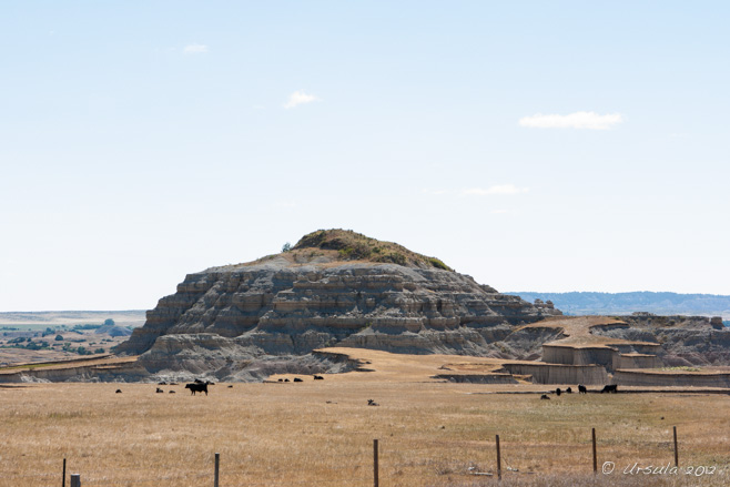 Mesa on Highway 73 South
The land south of Kadoka is hot, dry and dramatic. 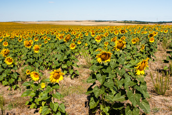 Sunflowers
, wheat, and hay appear to be the only crops.  Stop!
Road works are everywhere, and Native Lakota from the Pine Ridge Indian Reservation are on the job. A Kadoka School
School’s out! The “Drug and Weapon Free Zone” sign shouldn’t really be necessary, should it? Slow!
A Lakota woman working the road crews smiles as she makes us wait – Follow Me!
… and we are finally off, through the dust and heat – Golden Bales
– past ploughed fields and to the next road works. Storage Silos on the Horizon Lakota Arts and Crafts, Wounded Knee
This inauspicious site is our first indication of what is supposed to be an official U.S. National Historic Landmark. I guess every country and culture has moments that it is not proud of; Wounded Knee has seen two major cultural clashes, both of which arose out of stubbornness and resulted in loss of life.
The original battle, the Wounded Knee Massacre, took place on December 29, 1890. Causes are never simple, but the combination of: bison herds being hunted to near extinction; Sioux people being forced off their lands after dubious unfulfilled treaty agreements; the recent death of Sitting Bull, eight of his supporters and six policemen; a new Native American Ghost Dance religion that had believers thinking they were immune to bullets; over-zealous and heavy-handed Cavalry; and firearms discharged (accidentally and intentionally) at close range, resulted in a pursuit and massacre of up to 300 Lakota (mostly women and children) and the death of more than 25 soldiers, many by friendly fire.
Three days of blizzard followed, and the civilians hired to bury the dead Lakota found the bodies frozen. Even so, four infants were reportedly found alive. One of these was the child who came to be called Zintkala Nuni, or Lost Bird. She was handed around for some time before being adopted by Gen. Leonard Colby, whose suffragist wife, Clara Bewick Colby, was left to raise her – especially after he abandoned Clara for Zintkala’s nursemaid/governess and failed to provide adequate support for either dependent.
Lost Bird endured a short and difficult life, accepted by neither culture, and suffering from prejudice, poverty, abuse and violence before ultimately succumbing to influenza and dying on Valentine’s Day at age twenty-nine. In 1991, her body was moved from her pauper’s grave in California to the sad little graveyard at Wounded Knee. One of the young men I spoke with was an infant at the time, but his eyes grew wistful as he remembered his grandfather presiding over the ritual ceremonies conducted on that day.
Headstones
Graveyard, Wounded Knee Final Resting Place
Zintkala Nuni (Little Lost Bird) is finally home at Wounded Knee. Feathers on the Fence
Catching dreams and memories for loved ones… The second Wounded Knee Incident was in 1973, when the town was occupied by members of the Oglala Civil Rights Organization (OSCRO) and the American Indian Movement (AIM) and became the rallying point for an often violent protest against the corruption of a local tribal president, and the failure of the US government to fulfill treaty promises.
Lakota Center, Wounded Knee
In a round building in the middle of nowhere… Manning the Centre
… a Lakota man tried to explain the history of the centre and of his people. The whole atmosphere was ineffably sad. Both the place and the people seemed wounded – with the scarring improperly healed. The young men I spoke to talked about the conflict of cultures and the lack of opportunities. One worked as an itinerant farm hand – when there was work to be had. He used to have six cows himself, but sold them during hard times. He told us how, the other morning, half asleep, he found a neighbouring (white) rancher’s cows on his doorstep. “For a moment, I thought I’d got lucky,” he mused dreamily. Then he woke up with a deep sigh.
It is hard to know how to respond to that kind of hopelessness.
Feeling deeply affected, we continued west and stopped at the small city of Hot Springs for lunch.
There, we learned about a whole different historical epoch. As it turns out, Hot Springs is home to a karst sinkhole formed approximately 26,000 years ago. During the last ice age, mammoths and other animals were attracted to the warm spring waters and the vegetation growing around the pond. Once in the steeply-sided pond, the animals could not escape, dying of starvation, exhaustion, or drowning.
The covered-over sink hole was discovered in 1974 when the owner of the property found what turned out to be mammoth bones on his land. The property was sold back to a trust, and The Mammoth Site was born. A climate-controlled building was constructed over what is now a working paleontological dig and a fascinating view into the plants and animals of the Pleistocene era. So far, the fossil evidence of 58 columbian mammoths and 3 woolly mammoths (all male; mostly young) have been found, along with remains of plants, giant short-faced bear, camel, llama, prairie dog, wolf, fish, and numerous invertebrates.
Brandon
Our “interpreter” was informative and amusing, as he walked us through the history of the centre and the geology of the site. Painstaking Work
Uncovering the fossils takes patience and time – students at all levels and visiting professionals take turns working the dig. Walkway
The elevated walkway allows visitors a good view of the site and the work going on, but still keeps them out of the way. It was a fascinating visit, and elevated our mood somewhat after the morning’s experience. Checking the maps again and realising we could drive through Wind Cave National Park and Custer State Park to get to Mt Rushmore, cheered us up further.
A Big Male
After their near extinction in the late 1800s, bison were saved by the American Bison Society and reintroduced to the park in 1913-1914. Bison Herd
Bison numbers have grown; too late, of course, for the Lakota and other Sioux tribes. White-Tailed Deer (Odocoileus virginianus)
A mother deer with her young fawn, watches the road skittishly. Baby Burro
The now-wild burros of Custer State Park beg for food from drivers. A Pair of Pronghorn
Pronghorn (Antilocapra americana) are now quite numerous in western states. The Iron Mountain Road
This feat of engineering winds through the Black Hills and passes through three tunnels that frame a very faint Mount Rushmore in the distance. Over the Woods
Pine and spruce forests, Custer State Park Tunnel Vision
Mount Rushmore in the distance. Mt Rushmore By the time we reached Mt Rushmore, the shadows had grown long, and I’d lost enthusiasm for visiting oversized carvings of powerful white men, etched into a mountain with little regard for the original residents of the Black Hills below. According to “Honor the Treaties”, a short film I came across recently, 90% of Lakota today live below the US poverty line the life expectancy of males is only 47.
Afternoon Light over the Dakota Grasslands Sunset over the Black Hills  Sobering thought – after a long day’s drive through the sacred hills. Sobering thought – after a long day’s drive through the sacred hills.
Lets hope they can do better in the future.
Photos: 17August2012
Posted in America,Animals,History,pre-historyTags: animals,blog,environmental portrait,environmental portraits,National Park,nature,people,Photo Blog,portrait,portraits,South Dakota,State Park,travel,Travel Blog,Ursula Wall,USA
Hsinbyume Pagoda
Seven concentric terraces, representing the seven mountain ranges going up to the mythological Mount Meru, form the base of Hsinbyume Pagoda, Mingun. There are ups and downs when traveling with a photo group.
One of the most important advantages is time: a group of people aiming to make pictures will often stay in one place long enough to experiment with light and angles and to focus on details, long enough to make the average non-photographer fidget with boredom and restlessness.
Being with a group of photo enthusiasts means that you have access to lots of advice and input. On the flip side, it can also mean being overwhelmed by other people’s styles and and ideas, and having difficulty holding on to your own.
It means being put in the right place a the right time. It also means competing for space and having to work around others – and taking lots of dud pictures that include other people’s lenses, feet, heads, flashes, and other body- and camera-bits.
Sometimes, like at Hsinbyume Pagoda in Myanmar last September, with photographer Karl Grobl and guide Mr MM, it means having “models” organised. This is always a lot of fun, and is much easier than negotiating permission with subjects yourself. However, it also means waiting your turn while subjects wilt in the heat, losing the moment, or having the eyes of your subject drawn away by someone else, just as you are about to take the picture you have been warming them up to.
But, it provides a welcome opportunity for photographic exercise. For me, Hsinbyume Pagoda was a challenge in lighting: dark skinned novices in dark robes contrasting severely with a white pagoda against a whiter-than-white sky; dark skinned novices in dark robes disappearing in the dimness of the pagoda’s interiors.
It also gave me a chance to make the kind of “orchestrated” photos that I don’t normally take.
Novices on the Waves
Four young novices arrange themselves on the terraces at the base of Hsinbyume Pagoda. Ready!
The young novices wait for everyone to take their pictures. Little Novice
Against the white waves of the pagoda, glaring in the heat, a young novice tidies his robes. Little Novice Don’t tell the Abbot! Novice on the Run
Our novices engage in some rather un-monkly behaviour for our benefit. Novice on the Waves Novice in Flight The whole group climbs the stairs up to the pagoda… … to take pictures of a young novice on the path outside it. In the Heat of the Day Novice in a Doorway
Inside the pagoda, it is dark and textured – Novice in a Doorway
– making a foil for the young novices. Novice on a Walkway
Outside, on the walkway, the heat continues to radiate in all directions. Prayers
Meanwhile, inside, a couple say their prayers… … and the grass grows wild and rubbish collects on the terraces. Soon it is time to descend the stairs, pass the money collection bins, and exit the pagoda ~ and to reenter the “every day” world… where more “natural” photos await. Certainly, there are pros and cons of traveling with a photo group.
 But I love that it gets me to places I might not otherwise go, and stretches me to make pictures I might not otherwise attempt. But I love that it gets me to places I might not otherwise go, and stretches me to make pictures I might not otherwise attempt.
And, ultimately, it means coming home with so many pictures it is hard to know where to start!
‘Till next week…
Pictures: 15September2012
Posted in Myanmar,Portraits,TravelTags: architecture,blog,buddhism,buddhist,children,environmental portrait,Myanmar,people,Photo Blog,portrait,portraits,religion,temple,travel,Travel Blog,Ursula Wall,worship
Kings Road, Brighton
Rugged-up against the weather, pedestrians make the best of a break in the rain. Rumour has it that Great Britain has experienced a true summer this last July. This “heatwave” has health professionals worried, while other Britons head to the beach to bask.
Of course, it isn’t usually so. Last July, when we visited Brighton Beach for two days, the weather – rain and black clouds with intermittent sunshine – was probably more typical of an “average” British summer.
Naturally, if you only have a day or so to visit a place, you take the weather as it comes! But, while Brighton has been known as a health resort for sea bathing since the 18th century, and became a popular day-trip destination for Londoners with the arrival of the railway in 1841, it really wasn’t turning the beach weather on for us.
West Pier
Built in 1866 and abandoned in 1975, the ruins of the West Pier sit against threatening black clouds. Hardy Britons enjoy the waterfront regardless. Hot Fish
No matter what the weather – it is always time for fresh fish and chips! Beach Ball and Chain?
Brighton’s waterfront is reflected in a large disco ball. On the Pier
Protected from the elements by raincoats and umbrellas, tourists venture out onto the famous pier. Look to the Surf…
Bodyboarders defy the cold Atlantic to catch a few “waves”. Tarot and Rain
“I see showers in your future.” Rain and Lace
Built between 1891 and 1899, the Brighton Marine Palace and Pier, as it is officially called, features some wonderful wrought iron work. The Brighton Wheel
Not too many takers on this day; the carriages all appear to be empty. Dress Shop
Taking refuge in quaint stores is one way to escape the climate. The Royal Pavilion
Built in the Indo-Saracenic style popular in colonial India in the 19th century, the Brighton Pavilion was a royal retreat for George, Prince of Wales, later King George IV, from 1787 onwards. Playing the Crowd
During a brief respite from the rain, people wander through the Royal Pavilion grounds. Clarinet and Bubbles
Like magical musical notes, bubbles float on the air while the clarinetist plays on. Brighton Street
The next day, the weather was much improved… Brighton Beach
… but black clouds still loomed over the rocky, shingle beach. Beach Chairs
Canvas chairs sit empty. Rust and Ruin
Old boats and bits of machinery are out-door parts of the Brighton Fishing Museum. Cockles and Lobster Tail
Cups of fresh seafood are available from the fridge… Smokehouse Door
… or you can buy something from one of the many shops in the converted row of Victorian fishermen’s workshops. Punch
Originally the Italian Pulcinella, Punch (with Judy and a cast of characters) became synonymous with beach entertainment. Fish Nets and Crab Traps
The Brighton Fishing Museum is dedicated to all things maritime. Carousel Pigs!
Shop keepers, trusting the rain would hold off, moved their wares out of doors. Royal Pavilion
After walking the distance between the two piers, we couldn’t resist returning to see what the Royal Pavilion looked like in better weather … Domes and Minarets
… and it is lovely … Brighton Royal Palace Gardens
… but, as dark clouds rolled in again, we decided it was best to leave!  We escaped back to our vehicle – umbrellas hoisted – as the raindrops started to fall.. We escaped back to our vehicle – umbrellas hoisted – as the raindrops started to fall..
I hope this year’s visitors realise how lucky they are to have genuine summer, beach weather.
Happy Travels!
Pictures: 14-15July2012
Posted in Great Britain,Landscapes,TravelTags: architecture,beach,blog,boats,England,Great Britain,Photo Blog,travel,Travel Blog,United Kingdom,Ursula Wall
Morning is Breaking
The sun peaks over the Bodie Hills and through the Red Cloud Mine head-frame and man lifts.
Bodie State Historic Park, California, USA Cold.
Dark. Completely dark – but for the stars overhead – and cold.
And early! Way too early.
It was 5:15am in California’s Eastern Sierras. A small clutch of cars and a congregated group of people with their hands shoved deep in their pockets, huddled against the kind of piercing cold that only a dry climate can produce in high summer, were stopped at the entry to Bodie State Historic Park,
It was 14 miles (three of them unpaved: rough and bumpy) from the nearest tiny town, and we were waiting for a Park Ranger to arrive and grant us access to the grounds. On the third Saturday of every summer month, the Bodie Foundation gives people the opportunity to photograph the Californian gold mining ghost town of Bodie in the early morning light (for a fee).
Head Frame and Machinery
The first sights, once we are out of the car park, are old bits of mine machinery: rough and textured in the pre-dawn light. This early access allows photographers to wander around the almost-empty town before the “tourists” arrive at the official opening time of 9:00am. For me, it was a chance to try out the new tripod I had bought especially for the occasion. Tripods are a handicap rather than an asset on the kind of travelling I usually do, so this was a rare opportunity to practice shooting with one.
Pre-Dawn over Bodie
What is left of what was once a thriving (and nefarious) mining town is preserved in a state of “arrested decay.” Bodie Ruins
The ramshackle nature of Bodie reminded me of Sweethaven, the town that threatens to fall into the sea in the 1980 film “Popeye“. Methodist Church
Built in 1882, the Methodist Church is the only church remaining in town. The last service was held here in 1932 when the town was already in serious decline. Named for Waterman (William) S. Body who found gold in the hills here in 1859, Bodie grew to be a town of 10,000 by 1879. The two churches were no match for the 65 saloons and rugged lifestyle; Bodie soon became known as the “most lawless, wildest and toughest mining camp the far west has ever known”. Robberies, stage hold-ups, street-fights and even murders were almost-daily events.
Bodie’s heyday was short-lived: by 1881, mining declined and homes and businesses were abandoned. Fires in 1892 and 1932 destroyed much of the town. Although it has been referred to as a “ghost town” since 1915, Bodie still had a total of 120 people at the 1920 US Federal Census, and has never been completely abandoned: dropping to three residents in 1943. Today, some of the California State Park rangers live on site, and we had to shoot “around” a modern white vehicle that was parked in plain view.
Sunrise over Bodie
Some of the 110 remaining buildings in the morning sunlight. Bodie Sawmill
Remnants of old buildings give us some insight into the workings of the town. JS Cain House
Looking through the windows to see what old wares have been left in the dilapidated buildings is part of the Bodie adventure. Bird on a Wire
Swallows are some of the many birds who make Bodie their home. Sunbeams and Sage
As the sun warms up the landscape, the wonderful smell of sage grows stronger. Buildings and Machinery Bodie Wagon Through the Windows
Smeary shopfront windows hide a treasure-trove of old wares. Gas Pumps and Dodge Graham A Music Room Young Blackbird Ranger Aleta
A ranger talks about Bodie’s history, while cleaning the schoolhouse windows. Education: A Window on the World
Light and reflections through the schoolhouse windows. Cottage Fence Bodie Hills Rusty Pipes
Bodie is a genuine ghost town: bits of rust, glass and broken wood are everywhere! Bodie Truck Diagonals Through the Frames Through and Back Lines of Light Hotel Reflections
Patterned reflections in the front of the Wheaton & Hollis Hotel. Leading Lines
Some old pipes in the grass lead the way back to the car park.  By eleven o’clock, the sun was high overhead, and the air was radiating heat. By eleven o’clock, the sun was high overhead, and the air was radiating heat.
It was time to leave the site to the tourists, armed with their guidebooks.
And the ghosts.
Happy Rambling!
Photographs: 20July2013
Posted in America,Architecture,History,USATags: architecture,blog,history,museum,Photo Blog,ruins,State Park,travel,Travel Blog,Ursula Wall,USA
Dandelion Cliffs
Sunny dandelions greeted us as we climbed the walkway to view the magnificent Cliffs of Moher, County Clare, Ireland. It was pouring.
Of course it was! It rained every day of our visit to Ireland last June. Not all day, but every day.
The silver lining was that were were going to be comfortably seated on a bus tour of County Clare all day, and not walking the wilds of the Dingle Peninsula, County Kerry, as we had been the day before. And, it IS that rain, after all, that makes Ireland the “Emerald Isle”.
We were meant to be heading into some of Ireland’s “most stunning scenery”. So, we picked up our umbrellas, packed our raincoats, and crossed our fingers.
It was still pouring when we arrived at our first brief stop at the ruins of Leamaneh Castle; my husband (holding the umbrella) and I (wielding the camera) were the only members of the tour group who even got out of the bus.
Leamenagh Castle Ruins
The original Leamenagh Castle was built around 1480 by one of the last High Kings of Ireland. The manor house was added in 1648 by Conor O’Brien and his wife, Máire ní Mahon. Connor died early, and his widow became known as “Máire Rúa” (Red Mary) due to her flaming red hair. She is one of the most infamous women in Irish folklore, probably because she was able to retain her estate via two politically astute marriages. The rain continued as we pulled up to our second, longer, stop at Caherconnell Stone Fort, a stone ringfort dating back to 400 AD. We braved the wet and took the self-guided tour through the magnificent stone ruins.
Caherconnell Stone Fort
The self-guided tour takes the visitor through the ringfort, built by farmers around 400 AD and left much as it has been found. Walls of the Fort
Like other ringforts, Caherconnell was probably built as a defence against animals and raiders. Almost perfectly round, and between 140-145 feet in external diameter, it would have housed a small settlement. Hawthorn
Ringforts are commonly referred to as fairy forts: fairies live in the forts or in the hawthorn trees that grow in them. It is considered unlucky to cut these trees down. Ferns
The walls are 12 feet thick, built from large blocks, as much as three feet long and two and a half feet high. This makes them a perfect home for moss and ferns. The rains eased off but the grey skies hovered for our third stop at a portal tomb: the fascinating Poulnabrone Dolmen – a neolithic burial site probably dating between 4200 BCE and 2900 BCE.
Poulnabrone Tomb
Poulnabrone dolmen (Poll na mBrón in Irish, meaning “hole of the quern stones”) is a neolithic portal tomb thought to date to 3800 BCE. Poulnabrone Tomb
The twelve-foot slab-like capstone sits on slender portal stones. The chamber underneath was the last resting place for almost thirty adults and children, as well as various personal items. Limestone Pavement
The porous limestone pavement around the tomb is pockmarked and slippery with moss and moisture. I was thrilled to stop for lunch overlooking Galway Bay, not only because I was hungry and and the food was terrific, but because I could muse about my ancestors who had emigrated from across those same waters only a few generations before.
Galway Bay
Calm waters and a patch of blue sky greet us at our lunch stop in Ballyvaughan Village. Monks Pub
Justifiably famous for its seafood, the pub was a welcome stop. As the skies cleared further and the sun came out, we continued southwest across the Burren (Boíreann, Irish for “rocky place”) and stopped for a scramble across the glaciated limestone karst “pavement”.
The Burren
Ponies graze on the short grasses that grow in the sparse soils atop the limestone rocks. Stone Wall Still Life Found: Stones and Flowers
Livestock love the Burren because the limestone holds the heat. Flowers in the Fissures
The vertical fissures (grikes) hold water, supporting pockets of plant life. Puddles of Life Bus on the Burren
Our bus sits on the Black Head Coastal Drive, awaiting our return, so we can drive to our last stop. Cliffs of Moher
Our final stop is at the stunning 214m (702 feet) tall Cliffs of Moher – thank heavens the sun is shining! Curving Cliffs
The cliffs, which have been used in numerous movies, including The Princess Bride (1987), stretch for 8 kilometres (5 miles) along the Atlantic coast. Information Centre
The Visitor’s Centre, featuring informative displays and stunning photographs, includes cafeterias, restrooms, and a gift shop. It is built into the hillside, but surprisingly light and airy inside. O’Brien’s Tower
In the other direction lies O’Brien’s Tower, built in 1835 by Cornelius O’ Brien, and used as an observation tower. Cliff Tunnel
Comprised of bands of Namurian sandstone, siltstone, and shale, the cliffs are wonderfully varied, and noisy with nesting bird life. Dandelion Cliffs
One last look at the towering cliffs, and it is time to return to our lodgings in Shannon. The Great Hunger
On the way home, we stop briefly at the statue of an orphan child at a Poorhouse door – a grim reminder of another facet of Ireland’s long and rich history. It was a typical Irish day: starting in rain and ending in brilliant weather.
We heard historical tales – ancient and modern – told with a mixture of poignance and humour. We experienced remarkable sights, natural and man-made.
And, it goes without saying, we ate and drank well.
Sláinte!
Pictures: 28June2012
Posted in History,Ireland,Landscapes,Nature,TravelTags: blog,Co. Clare,history,nature,Photo Blog,ruins,scenery,travel,Travel Blog,Ursula Wall
« Older posts
Newer posts »
|


")

A day of widely ranging emotions, with stark beauty
very interesting report Ursula. Greetings, Dietmut
My mother taught weaving on the Pine Ridge reservation during the ’70s. She was arrested and thrown in jail while trying to leave the reservation after the news reported the stand off was over. Crazy sad history there. Another terrible epoch in American history was the 1864 Sand Creek Massacre in Eastern Colorado, where one of my ancestors was involved in the killing of many Cheyenne women and children.
Your mother was clearly an amazing woman in her day, Katy! I guess that is where you get your grit. 😀
The whole “clash of cultures/beliefs” thing is ineffably sad, isn’t it? And, we as a people don’t seem to be getting any more tolerant of difference.