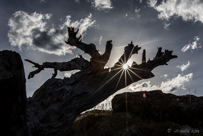
The Last Sun of 2013 Late afternoon at Charlotte’s Pass, in Australia’s Snowy Mountains (31 December 2013).
2013 was a big year in our house – with excitement and challenges; travel and change – but it ended much as it began for my husband and myself: with time out in the Snowy Mountains of Australia, communing with nature.
As visitors to this PhotoBlog know, this is something of a habit for me. I always book some quiet time into the schedule between Christmas and the early New Year; time to look back at jobs completed and things achieved, and to look forward to new goals and unfinished business.
When it is practical, I spend this time in Jindabyne and Kosciuszko National Park (e.g., Snowy Mountain High). We do make it into the mountains at other times of the year, whether it be just to walk or to enjoy the annual Thredbo Blues or Jazz Festivals, but December-January we make a point of visiting. The alpine flowers are out and the weather is beautiful; just the right environment to recharge ones batteries after a hectic year.
So, please join me for some quiet moments in the mountains.
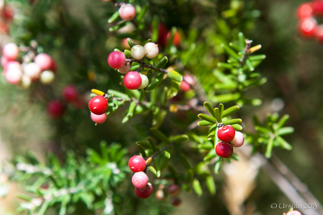
Summer Berries Bullocks Track (18 January 2013).
Kosciuszko Express Chair Riding up to the top of a misty Mt Crackenback (19 January 2013).
Mt Crackenback Looking over the granite outcrops back down towards Thredbo Village (19 January 2013).
Kosciuszko Lookout Trail Walking through the rocks and heath above the treeline towards Mt Kosciuszko, which is still hidden over the hill (19 January 2013).
Silver Snow Daisies (Celmisia asteliifolia) The season peaked early, and by mid January the snow daisies were already past their prime (19 January 2013).
Textured Bark Eucalyptus forests are full of textures and colours: Waterfall Track (20 January 2013).
Stump of a Veteran Waterfall Track (20 January 2013).
Dandelion Make a wish! (19 January 2013)
Alpine Podolepsis (Podolepsis Robusta) At first glance, these can be mistaken for dandelions…
Alpine Podolepsis … but a look at the leaves reveals why they are called “Mountain Lettuce”.
Waterfall Track Just under 6km, this is a delightful walk through the lower eucalyptus forest.
Orange Everlasting (Bracteantha Subundulata) After the silver snow daisies, the everlastings are my favourites: Rainbow Lake Walk (22 January 2013).
Yellow Floating Heart (Nymphoides pelota) Non-natives, the fringed lilies are none-the-less a delightful addition to Rainbow Lake.
Gunn’s Willow-herb (Epilobium Gunnianum) The delicate Gunn’s Willow-herb is easy to miss in the tall snow grass.
Native Bluebell (Walhenbergia) There are at least three kinds of native bluebells in the park; I can never remember which one is which.
Rainbow Lake It is a short walk (3km round-trip) through snowgrass and snow gums to Rainbow Lake – originally a dam to supply water to nearby Hotel Kosciusko, which burnt down in 1951.
Lichen More eucalyptus colours and textures (22 January 2013).
Snow Gum (Eucalyptus Pauciflora) Blossoms The blossoms of the snow gum are surprisingly delicate, considering the rugged conditions they live under (31 December 2013).
The Main Range One of the first things we do on every visit to the High Country is walk up the short Snow Gums Boardwalk to have a look over the Main Range. There is very little snow remaining at the moment (31 December 2013).
Tall Rice Flower (Pimelea Ligustrina) There are delicate colours in every crevice..
Tall Rice Flower (Pimelea Ligustrina) … and delicate flowers on every plant.
Alpine Mint-Bush (Prostanthera Cuneata) The beautiful-smelling Mountain Mint tells me I have arrived (31 December 2013).
I hope you have enjoyed your holiday season, and wish you all the best for a happy, healthy new year.
[…] of Kosciuszko National Park. Usually we plan at least one ambitious alpine walk (e.g.: Bookends on 2013, Alpine Bookends 2014, Illawong Lodge, Guthega, or Summer Walks in the […]ReplyCancel
[…] Lookout; Porcupine Rocks; Mount Kosciuszko Summit; Mount Stillwell; Seaman’s Hut; Waterfall Track; Rainbow Lake; Illawong Lodge; The Old Geehi Huts; etc.), but we usually try to […]ReplyCancel
Mr Tikam Chand Jaipur street portrait photographer.
When do two negatives make a positive?
When you are dealing with film – that tricky stuff that used to be in all our cameras. Every so often I come across a forgotten roll in a box somewhere, but I haven’t used it for years. Recently, however, I met a man who still shoots – and develops – film.
It was Jaipur. Mid-morning. Nine photography-enthusiasts were seated on a bus which was stop-starting its way through the crowded streets.
Photo-guide Karl Grobl and local guide DV – Digvijay Singh were at the front, alternating between conspiratorial whispers together and animated telephone conversations in Hindi. Finally, the good news: “We found him! He’ll see us.”
Somehow, our driver turned the bus around in the busy, narrow streets, and we tumbled out into the Hawa Mahal district of Jaipur with all our whiz-bang digital camera equipment in tow.
A short walk up a road with market shops on one side and street vendors on the other, and we found the “studio” of Mr Tikam Chand, grandson of the man who was the official Royal Photographer for the Maharaja of Jaipur in the 1800s.
The “Minute Camera” The same 1860 Carl Zeiss wooden camera with its built-in dark room that took pictures of royalty during the Raj now takes tourist pictures in the street.
Clippings Yellowing photos and news reports tell the story of the old camera and the two brothers, Surendar and Tikam Chand, who have operated it since it was passed down to them in 1977.
Street Photography Travellers, with their digital cameras, take pictures of the 150-year-old camera while Tikam Chand talks to guide DV.
Setting Up Mr Chand likes his customers to be seated perfectly: he is ready with a comb and mirror.
Checking Settings Tikam Chand checks settings ‘under the hood’ while his portrait subjects wait patiently. Focus on the camera is adjusted by sliding the lens back and forth inside the wooden box.
Letting in the Light Tikam Chand has a finely developed sense of light and time. The old camera has no shutter release; he simply removes the lens cap, counts off in his head, and replaces the cap.
Look into the Lens! The aperture can be adjusted from 4.5mm to 32mm using a brass bracket around the lens. The Jaipur street gets hotter as the mid-morning sun rises.
Jan and Lew Two group participants smile for the camera…
The Wonder of Optics … and their image inside the camera is upside down.
Measuring When all the pictures are taken…
Pouring … it is time to mix the developing chemicals.
Water Rinse After their chemical bath, the negative prints get their water rinse.
Twine and Cracked Glass The photo plates on the archaic wooden camera – reputedly the last of its kind in the world – are held together with twine. Cracked glass guards precious old photos.
Negatives Negative prints are pinned up to be photographed to produce positive images…
Chemical Rinse … and the whole development process is repeated.
The Exchange A customer pays for her fresh prints – negative and positive. The package needs to stay covered in newspaper for thirty minutes or longer. Tikam and his brother are having more difficulty sourcing the appropriate paper and chemicals these days, so prices have gone up. We payed 500INR ($8) for each of our photo sets. Well worth it for the experience!
As we count down the days, looking forward to the new year, it is worth looking back as well, back to how things once were, and to preserve the knowledge, skills, and traditions of the past.
For it is “the old way of doing things” that has given us something to build on.
Awesome story, awesome images, and told only as Ursula can do…I so enjoyed reliving every moment of that encounter in Jaipur through your words and pictures. Thanks Ursula for this holiday gift, you’re amazing! Happy Holidays, KarlReplyCancel
I took my best family portrait with Mr Surendar in 2006. You can see a photo in my portfolio from India, photo 5 (http://luisduarte.com/eternal-india/).
Aughnanure Castle Gray skies, lush green lawns and another castle to explore: sounds like a typical day in Ireland.
There are no straight roads in Ireland. The country is dotted with lakes and bogs, and the carriageways meander around them, taking in sites and villages along the way. This makes for charming and unhurried driving – there is no point rushing or trying to get too far in any one day.
Of course, this can make route mapping challenging.
We had pre-planned a visit with a friend in Waterford towards the beginning of our month in the Emerald Isle last year, and we had pre-booked our ten day walk around the Dingle Peninsula. We needed to be in Dublin at the end of our time, but the rest we were working out as we went. I had in my possession, along with road maps and pamphlets, a Michelin Green Guide, and I was being influenced by their star ratings.
That was how we decided to include the wild Connemara region of West Galway and the ancient monastery Clonmacnoise– both “Highly Recommended” – in our travel plans. It was while trying to negotiate transport between these two sites that we decided to rent a car rather than rely on local buses.
So it was that on yet-another-rainy day in July, we were driving southeast from Clifden, Co Galway, back through Galway City to reach Athlone, in the middle of the country – stopping at sites along the way.
Our first stop was less than an hour from the start of our day, at Aughnanure Castle, a testament to the formidable O’Flaherty clan, who built the tower house around 1500.
Caisleán Achadh na Nlubhar ~ Castle in the Field of the Yews Aughnanure Castle stands on a rocky “island” near Lough Corrib; the walls are flanked by waterways and trees – even if only one ancient yew (not pictured) remains on the site.
Outside Castle Walls Aughnanure Castle can barely be seen through the trees, as a sow roots around by the creek.
Black and White Sow
Approach The rains came and went as we approached the castle entrance.
Inner Bawn A bábhún(bawn) is a defensive wall surrounding Irish tower houses. Aughnanure Castle is unusual in having two: the southeast corner turret is all that remains of the inner wall.
Castle Walls The walls around the castle are in differing states of repair.
Windows A view through the thick castle walls to the outside, and from an upper balcony into the banquet hall. The castle boasts a “murder hole” and a secret chamber, so is rather fun to explore.
Early Bird Inside the castle walls, the wet lawns are a rich source of bird food for this thrush.
“Pony, Meet Pig!” Back outside the walls, the sow decides to investigate a pony… and we drive fifteen minutes further down the road to lunch and our next stop.
Moycullen Wet streets and window wipers: the rains continue.
Richly Coloured Connemara Marble Moycullen is home to the Connemara Marble Factory & Visitor Centre.
Marble Machines The big machines were quiet when we visited…
Marble Workers … but the workers were busy: carving and polishing the locally-quarried marble.
The Arch, Athenry Thirty minutes later, we were driving through the Arch or Northgate of Athenry. The arch was originally built as one of the seven gateways into the town. The original town walls were built during Norman times, but there is some evidence that this, the only remaining gate, was built a little later.
Rock Following a vague description in the Green Guide, we drove around in circles for a while, looking for a famous stone carved in the Iron Age. Rest assured, this is NOT it. We found out later that the Turoe Stone had been moved, and though we drove through Knockacullen several times hunting for it, we saw no signposting!
St Peter and Paul’s Church The Roman Catholic church, completed in 1937, was an imposing sight as we came into Athlone.
“Be Still and Know that I am” Not surprising, I suppose, that in a Catholic country like Ireland, it was as easy to find religious objects for sale as it was to find dinner.
We did, of course, find food – and wine and music – for Ireland isn’t only about history and scenery and devout faith.
My computer crashed the other day: locked up with a blank screen and humming motor, and refused to boot again. I don’t like to speak ill of my MacLemon, but this latest episode makes hard-drive number four in as many years – and I have also replaced a battery. What is worse, of course, is that without my Mac, I don’t have access to my pictures or the Lightroom catalogues they are stored in. Talk about First-World Problems, right?
I’m still waiting for the final verdict. In the mean time, I’ve dug out an archaic PC and found some old picture files from a wonderful trip we took a long time ago – to Argentina – back before I had a digital SLR or access to sophisticated processing. Still, it was nice to revisit the shots.
Lemons to lemonade.
If you want a great day out, I can’t recommend Glaciar Perito Moreno, Patagonia, Argentina, highly enough.
Of course, just to make life interesting, when we visited, our plane from Buenos Aires to El Calafate – the town where we were to be based – took us the long way around: via Tierra del Fuego, that southern-most tip of South America; the jumping-off point to Antarctica.
Although we weren’t allowed out of the airplane, I can still say I landed at the end of the world.
Tierra del Fuego Flying into Ushuaia – last stop before Antarctica.
In El Calafate we stayed in a hostel – you know: one of those places with ply-board walls so thin you can hear the neighbours breathe (and the rest!) and with dodgy plumbing and no water pressure, so that the water sliding from the shower nozzle down the wall is not guaranteed to be warm.
The next morning, after a very early breakfast of some lightly crisped white stuff they called “toast”, we were bundled, with five other sleepy-headed travelers, our guide, and a driver, into a mini van for the pre-dawn drive to the bottom end of Glacier National Park.
Velvet Morning In a cold pre-dawn, we drove to the bottom end of Patagonia’s Glacier National Park.
As for the glacier itself, the pictures tell most of the story. They don’t show the noise, of course. There is nothing quite like the sound of a massive glacier heaving and groaning, especially when you are on it! The resonating booms and drawn-out splashes as bits fell into the water were simply amazing.
Floating Ice As the light comes up, the glacier comes into view in the morning mists, and we see ice pieces floating down the river.
Rock – Mountains – Ice It’s a stunning and dramatic landscape. The natural bridge over the two pillars collapsed March 13th, only days before our arrival. Apparently the noise could be heard 20 km away.
At the Front Parts of the glacier sit over 60 meters above the level of the water. We cruise across the front edge.
Boat on Lago Argentino Another tour boat motors across the huge lake.
Edge of the Glacier Once our boat was docked, we walked from ‘Refuge’ to a picnic area near the glacier’s terminus; I was never sure if that was the name or just a description.
Dirty Surface After we were fitted with our crampons, we started our walk across the glacier. It was surprising to me how rough and dirty the surface was.
Guide While our guide was describing the glacier, I heard what I thought was thunder; it turns out it was just the ice protesting.
Hole-in-the-World Drop something down a crevice, and it might show up again in 200 years.
Ripples on the Glacier The ice rolls in waves, making walking, even with crampons, difficult.
Have Ice-Pick ~ will Climb Our guide, unlike me, has no difficulty negotiating the terrain.
Group on the Ridge Like a caravan of camels on the desert dunes, there was another group in the distance.
The Famous Grouse As we climbed over the ridge, we saw what we thought was a weather station. It was scotch – which we drank with shaved ice and chocolates.
Crack and Splash Back at ‘Refuge’ after our walk, we listen to the ice crack off the front of the glacier and splash into the lake.
Perito Moreno Everything is impossibly bight – impossibly blue.
Coloured Rock The rocks have been well polished by ice and water over eons passed.
Carpet of Ice View from the walkway at Curva de Los Suspiros. The glacier stretches 30 km (19 miles) in length, and is 5 kilometres (3 mi) wide across at the lake. In spite of pieces falling off, this glacier is actually growing.
Lenticular Clouds Patagonia is famous for its spectacular cloud formations. These lenticular clouds look like UFOs against the blue sky.
Cerro (‘Hill’) Moreno Our last view of the glacier from the walkway at Curva de Los Suspiros.
Truly a magnificent landscape.
It may not make me feel better about my computer, but it puts life back into perspective.
[…] and maps from a long-ago trip to South America. Well, to be more accurate, from Argentina (see: Perito Moreno and El Chaltén) and Peru. South America is a big place! Naturally, the trip notes beckoned me […]ReplyCancel
Swallow-Tailed Kite “Wildlife Encounter Talks” are given every afternoon at Flamingo Gardens in Davie, Florida.
Florida welcomes you to the state with fresh orange juice and glossy brochures, and then subjects you to mile-upon-mile of billboards advertising everything from alligator airboats to the power of prayer. Endless highways and turnpikes are bounded by garish plastic storefronts advertising all manners of food, tacky souvenirs, alcohol, and entertainment.
I found it vaguely depressing, and very overwhelming. Fortunately, as I have written before (Kissimmee Lake), it is possible to escape. National Parks, Indian Reservations, State protected green spaces and privately bequeathed lands are never too far away, if you look.
Which is lucky.
We’d had a rough night. Our planned lodgings in Fort Lauderdale had collapsed spectacularly, and our attempt to find an alternative near the Everglades had failed. (The people I spoke to at the local gas station didn’t sound used to talking to tourists, let alone accommodating them.) We drove in circles, late into the evening, and finally ended up with a room at a dimly-lit strip motel where the “reception” was behind a locked grate.
So, I was determined to jump off the highway at the Flamingo Gardens, a not-for-profit botanical gardens and wildlife sanctuary, before continuing south into the Florida Keys.
It was a good decision.
Sun Parakeet The Sun Conure (Aratinga solstitialis) is actually a native of South America – but often found in captivity.
We escaped our dingy, overnight dungeon and were parked at the gardens before they opened for the day. We wandered around the parrots and macaws in the outside aviaries waiting for the doors to open, and once inside, didn’t leave until early afternoon.
Pink Ginger (Zingiberaceae) Flamingo Gardens is set on 60 acres of land, divided into seven distinct botanical zones.
Orchids The “Tropical Plant House” area includes orchids, calatheas and other high-maintenance tropical plants.
Wild Ginger (Zingiber zerumbet)
More Wild Gingers? The gardens are a feast of strange, tropical plants.
Erect Heliconia It must be the right time of year: colour peaks out from everywhere.
Harris’s Hawk We made our way into the “Bird’s of Prey” area…
Red Shouldered Hawk … where we met several rescued raptors…
Burrowing Owl … including this adorable little owl who came off second-best in a nasty accident.
Black and Yellow Garden Spider
Roseate Spoonbill In the large, walk-through “Everglades Free-Flight Aviary”, we were surrounded by some of the more-than-45 species of Florida native birds housed there.
Eastern Brown Pelicans Brown Pelicans live in Florida year-round ~
American White Pelican ~ while the White Pelican is a winter visitor.
Squirrel The Eastern Gray Squirrel, Sciurus carolinensis, is found in the southern parts of eastern Canada and throughout the mid-western and eastern United States.
School Children The Flamingo Gardens cater for school groups. Some of these children seem pretty excited to be so close to White Ibis.
Caribbean Flamingos “Flamingo Pond” is home to the eponymous waders.
Brazilian Red-Cloak (Megaskepasma)
Golden Candles (Pachystachys lutea)
Shade Trellis Delicate slipper orchids hang from the trellis where we wait for our “Narrated Tram Tour” around the wetlands and native trees.
The Wrays Floyd L. and Jane Wray came to Florida in 1925 and bought 320 acres of land. They were intrigued by the horticultural possibilities of the subtropical locale. Floyd and his business partner Frank Stirling founded Flamingo Groves in 1927, maintaining the indigenous plant life as well as cultivating exotic specimens and testing the viability of over 60 varieties of citrus. (History)
The Historic Wray Home The weekend home of the Wrays, nestled in a native hammock of Live Oak trees, many of them 150 to 200 years old, was originally built in 1933. Restored, it is now open to the public as a small museum.
Peacock Over four dozen peacocks live on the property.
Peacock Lucky for us, it was mating season.
Black Vulture The vultures nesting nearby are much less blessed in the looks department.
Northern Crested Caracara These impressive Florida natives are members of the falcon family.
Florida Bobcat The “Everglades Wildlife Sanctuary” section of Flamingo Gardens was opened in 1990, and was one of the first to house permanently injured or non-releasable Florida native wildlife.
Opossum Much maligned, North America’s only marsupials, opossums are omnivorous and often scavenge roadkill and household garbages. They are almost totally immune to rabies and snakebite.
I am grateful that Mrs. Wray established the Floyd L. Wray Memorial Foundation in 1969 in honour of her late husband, preserving the core property for us, and for future generations.
A few hours in the park sure improved my day ~
and we can all use a bit more nature in our lives.
[…] when the opportunity to get a little closer to our feathered friends presents itself (e.g.: Flamingo Gardens and On the Perch), I tend to jump at it. A couple of years ago, my husband and I were in Bali, […]ReplyCancel
- Performing the Ganga Aarti from Dasaswamedh Ghat, Varanasi
- Buddha Head from Shwedagon Pagoda, Myanmar
- Harry Clarke Window from Dingle, Ireland
- Novice Monk Shwe Yan Pyay Monastery, Myanmar
Packets of 10 for $AU50.
Or - pick any photo from my Flickr or Wanders blog photos.


 I hope you have enjoyed your holiday season, and wish you all the best for a happy, healthy new year.


 I am grateful that Mrs. Wray established the Floyd L. Wray Memorial Foundation in 1969 in honour of her late husband, preserving the core property for us, and for future generations.


")

[…] to take a walk through the alpine meadows or a hike up to Australia’s highest peak (e.g., Bookend on 2013; Snowy Mountain […]
[…] of Kosciuszko National Park. Usually we plan at least one ambitious alpine walk (e.g.: Bookends on 2013, Alpine Bookends 2014, Illawong Lodge, Guthega, or Summer Walks in the […]
[…] Lookout; Porcupine Rocks; Mount Kosciuszko Summit; Mount Stillwell; Seaman’s Hut; Waterfall Track; Rainbow Lake; Illawong Lodge; The Old Geehi Huts; etc.), but we usually try to […]