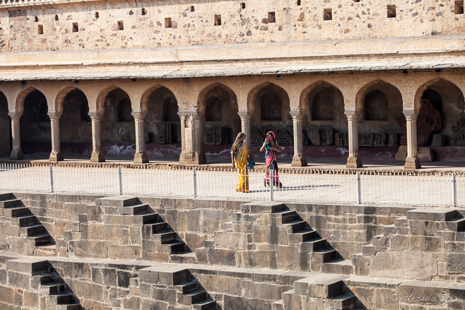
 Women around the Stepwell
The Chand Baori stepwell, built between 800 and 900 AD, gives us a glimpse into Rajasthan’s past. One of the pleasures of ground travel is the access you get to those places outside city centres. Ancient treasures and glimpses into the old ways of doing things can often be found just “off” the usual paths.
The ancient Rajasthani village of Abhaneri is only a fifteen minute detour off the main Jaipur – Agra highway. Abhaneri is home to a ruined tenth-century temple to Harshat Mata, Hindu Goddess of Joy and Happiness – and home to one of India’s largest and deepest remaining stepwells.
Stepwells. If you have never heard of them, you can be forgiven!
When I was doing background research on the Chand Baori stepwell in Abhaneri, I came across one site that called it “famous”. And, according to Wikipedia it was featured in the movie Paheli. I had to look that up as well: turns out it is a Bollywood film from 2005. Famous, perhaps – but not in my usual sphere.
Another useful website I found was entitled: India’s Forgotten Stepwells. So, not so famous after all! I’d seen pictures of women in saris against the Escherian-like steps leading into the well’s bottom – but I’ve never given the architecture or the purpose much thought.
Stepwells are found in arid regions of South Asia, extending into Pakistan, but are most common (according to Wikipedia) in western India. They were built to help solve the problem of having an unpredictable water supply in regions with long periods of dry heat, alternating with weeks of monsoonal rain. Surface water evaporates quickly in the dry season, and regular wells made water hard to access when the water levels dropped dramatically.
The earliest stepwells most likely date to about 550 AD, but the most famous were built in medieval times. It is estimated that over 3,000 stepwells were built in the two northern states [of Rajasthan and Gujarat]. Although many have fallen into disrepair, were silted in at some point in antiquity, or were filled in with trash in the modern era, hundreds of wells still exist. In New Delhi alone, there are more than 30.
I had never seen a stepwell before, and was keen to visit this well-preserved example of Indian architecture.
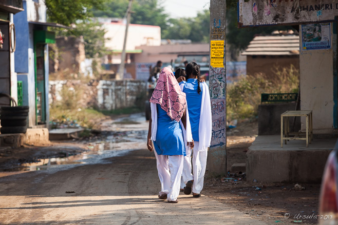 Girls Going to School
It always amazes me how crisp and clean students’ uniforms are in the mornings as they walk through the wet, dirty streets to school; Abhaneri, Rajasthan. 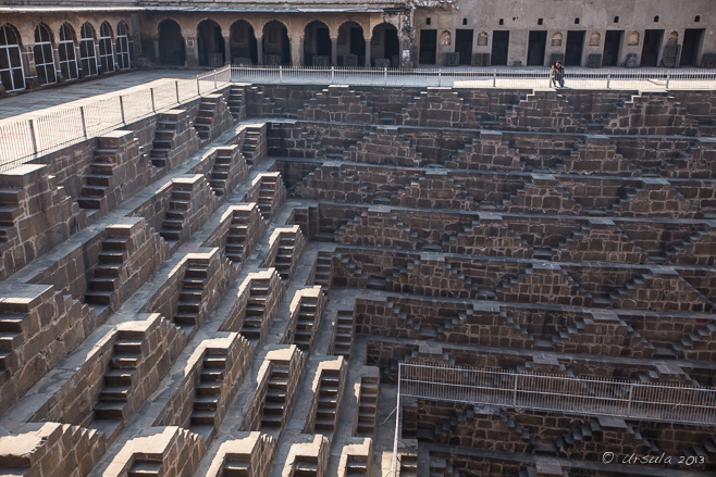 The Chand Baori Stepwell
Common in western India, stepwells not only provided access to cool water, they were a gathering place and the centre of many cultural activities.  Enter Escher…
This well was built by King Chanda between 800 and 900 AD and then dedicated to Hashat Mata, Goddess of Joy and Happiness. The 3,500 steps extend 13 storeys – about 100 feet or 30+ meters – into the ground. Family on the Walkway
Access to the steps is now fenced off for safety. The day we were there, no one was allowed in: no “women on the wall” photos for us. Young Woman in Green
Daily use of the stepwells was discontinued under the British Raj. Authorities, worried about hygiene and water quality, installed pipes and pumps to replace the communal wells. This change might have make life easier and safer, but it disrupted traditional social and religious practices. Young Woman in Blue
Instead of walking down into the well, the brightly-clad visitors promenade around it, … Young Woman in Pink
… happily stopping to have their pictures taken. Pavilions in the Stepwell
Covered “pavilions”, accessed by narrow ledges, provide a social function in giving shade, while also buttressing the walls against the intense pressure of water when the well is full. Stone Frieze Pieces
Build before the rule of the Muslim Mughals, the stepwell was richly decorated with Hindu art. Stone Frieze Pieces
Stone carvings of deities that have come off the original structure, are placed around the upper walkway. Blue Door The Potter and his Wife
Across the road from the stepwell, a potter works his wheel while his wife smokes a clay pipe. Working the Wheel
Everything is done by hand – even the spinning of the potter’s wheel. Repeating Circles
Each pot is shaped by hand, then placed on the board before firing. Hands of the Potter The Potter The Potter’s Wife The Potter at Work Woman Smoking
This clay pipe is one of the potter’s making. Firing The Clay Pots
These little clay pots are used for drinking chai, that wonderful sweet, spicy tea that is a staple of my diet when I visit India. The Potters Wife and the Wares
Samples of the potter’s wares sit on the edge of the firing pit as his wife smiles at the visitors. It was a short detour –
– but an interesting glimpse into the old ways; simpler, more social and communal, but much more labour intensive.
It’s a trade off, really. One that is being re-evaluated in today’s world.
Artisans are looking to age-old crafts for techniques and inspiration; social-scientists are studying traditional societies for models of social cohesion; and environmental planners and contemporary architects are re-examining India’s old stepwells as a potential solution to continuing concerns about access to water.

We can all learn from the past.
Namaste!
Pictures: 16November2013
Posted in Architecture,Every Day Life,India,TravelTags: architecture,arts and crafts,blog,environmental portrait,environmental portraits,people,Photo Blog,ruins,travel,Ursula Wall
With a Banjo and Flute
Hat Fitz and Cara Robinson are crowd-pleasers wherever they go – and we love ’em. Music festivals are a great opportunity to try new sounds on for size, but they are also a great place in which to give oneself up to the comfort of old favourites.
We did both at the recent Byron Bay Bluesfest; because we had indulged ourselves and pre-purchased five-day tickets for this year’s annual Easter Weekend music festival, we were able to pick and choose from a broad range of musical options. Of course, it is always wonderful to see the old classics – those living legends who embody the very history of “Blues and Roots” music – and to get a peek at, and a listen to, current hit-makers and chart-toppers. And we did both (Full Blast and Full Colour). We also enjoyed some “other-worldly” options that might not otherwise have crossed our paths (Cambodian Space Project).
But, we also looked forward to – and thoroughly enjoyed – some familiar, homegrown favourites. When I say “homegrown”, I mean resident Australian – though their roots, origins, and musical influences are far more wide-ranging. And, though they may be homegrown, rubbing shoulders with the international stars and musical legends at festivals has given them world-class polish and lustre.
Take Hat Fitz and Cara Robinson, for example. I first saw Hat Fitz perform at the 10th Byron Bay Blues and Roots Festival, in 1999, many years before he met his current wife and musical partner Cara Robinson at (the story goes) a music festival in her native Ireland in 2008. He has a voice of gravel; she has a vocal range and power that often has me choked with tears. Together, they are captivating. My husband and I first saw them together at the 2012 Thredbo Blues Festival, and we made sure to introduce our friends to them at last year’s Byron Bay Bluesfest, and this year’s Thredbo Blues.
Hat Fitz and Cara
The pair performed three times at this year’s Bluesfest. Early Friday afternoon found them in the heat of the Juke Joint: the Aussie “wild man” in his usual hat, shorts and thongs and the Irish “angel” in her 1940s-style curls. Cara Robinson
The couple have had some difficult times recently, and the resulting emotions have been written into some of their newest songs. Hat Fitz and his National Steel Guitar Cara on Washboard
The duo’s music crosses genres, but has been described as “shabby hill-country blues”. Cara’s washboard compliments Hat’s gravel tones on “Wiley Ways”.
(Double click to start Wiley Ways from the album of the same name by Hat Fitz and Cara.)
Their latest compilation, “Do Tell”, hadn’t yet been released by Bluesfest, so I give you (above) a sample from their previous album, which I have uploaded before.
Hat Fitz and Cara
The powerhouse pair opened the Delta Stage on Saturday. Cara’s vocals soared while Hat’s guitar sang. Banjo and Flute
Sunday, the couple were first-up on stage at the big Crossroads tent. Hat Fitz
The patter, story-telling, and cross-fire between the two as they change instruments between songs, is as entertaining as their music. Oh, Joyful Sounds!
Cara singing while on washboard. Cara on Pipe
Cara whistles us out on a traditional pipe. Another local act we’ve been privileged to hear before, is the young Genevieve Chadwick. The first time we saw her, at another Thredbo Blues Festival (2013), was the day she got the news that she had been chosen as one of only three Australians to participate in the international “Playing for Change” project. We also caught her first Bluesfest performance last year.
(Double click to start Down to the Bone from the new Playing for Change Presents Genevieve Chadwick album)
“looks like an angel”
Barefoot, sweet-faced Genevieve … … roars like a lion …
… has a powerhouse voice when she lets loose. … and plays guitar like a demon! At last year’s Bluesfest, our friends steered us toward a very local group: The Round Mountain Girls; Round Mountain being about an hour’s drive from the festival venue at Tyagarah Tea Tree Farm. We were sufficiently captivated to want to get in early for their only performance at this year’s Bluesfest, early on the last day. As before, they made me smile.
Round Mountain Girls
Chris Brooker, Chris Willoughby, Chris Eaton, Rex Carter, and Rabbit Robinson of Round Mountain Girls… Round Mountain Girls
… are five grown men having way too much fun! Rabbit Robinson
Master of stringed instruments and party animal, Rabbit plays like one possessed… Rabbit Robinson
… occasionally catching the spotlights as he bounces around the stage. Chris Brooker
The mandolin-playing Chris (Brooker/Boker/Broker) is also a song-writing contributor to the band. Jamie Symmonds
Performing on harmonica, guest Jamie joins the “Girls” for a few songs. Chris Eaton
Lead vocalist and player of banjos and guitars, … Chris Eaton
… Chris Eaton writes many of the Girls’ original pieces. Chris Eaton
Born in Liverpool England, Chris still embodies that innocent enthusiasm that epitomised the early Beatles of his home town. Round Mountain Girls
They are having such fun, you can’t help but smile!
[audio:https://www.ursulasweeklywanders.com/wp-content/uploads/2014/06/Faith_Mail_Chimp.mp3|titles=Faith|autostart=no]
Audio clip: Faith, from the Round Mountain Girls album, One Step Closer.

It is impossible not to get caught up in the enthusiasm, the energy, the raw joie de vivre that is live music –
But then, why would you want to resist it?
Keep smiling!
Pictures: 18-21April2014
Posted in Australia,Music,Performance,PortraitsTags: Australia,blog,environmental portrait,environmental portraits,music,musicians,people,Photo Blog,portrait,portraits,Travel Blog,Ursula Wall
Flying the Flags
The Jersey flag flies high over Elizabeth Castle, while the Union Jack presides over the courtyard. Jersey, the southern-most of the Channel Islands, packs a lot of history into a tiny space.
Much of this history is because of the island’s strategic location: only 12 nautical miles (22 km; 14 mi) from France. Functionally part of the United Kingdom since the Norman conquest of England under William the Conqueror in 1066, this little island in the English Channel has been an integral player in the ongoing European border disputes since that time.
Elizabeth Castle, built in the late 1500s to protect the island against the threat of French invasion, is a good example. The castle’s pedigree is like something out of a Masterpiece Theatre Historical Drama: the fortification was named for the Tudor English Queen, Elizabeth I, by the infamous explorer and courtier, Sir Walter Raleigh, who was Governor of Jersey from 1600 until 1603.
Elizabeth Castle was built on a rocky, tidal islet in St Aubin’s Bay – the same islet that was reputedly once home to the sixth century hermit and martyr, St Helier. The castle replaced Jersey’s original principal defensive structure, Mont Orgueil Castle, which had been built high over the harbour of Gorey in the early 1200s. That castle became indefensible, however, with the development of gunpowder and the possibility of ships with cannons attacking the growing city of St Helier.
King Charles II took refuge in the Governor’s House at Elizabeth Castle during the English Civil War; French prisoners were kept on the island during the Seven Years’ War; and the German occupying forces re-fortified the bunkers during the World War II.
Causeway to Elizabeth Castle
At low tide you can walk from St Helier, Jersey’s capital, to the rocky islet in St Aubin’s Bay – or you can make a crossing in one of the amphibious ferries at any tide. Cobbled Slipway
A steep slipway climbs up to the main gate, Elizabeth Castle. Hospital Building
A two-story barracks hospital building, constructed in the early 19th century, stands outside the main bastion. Crests on the Wall
The battlements around the castle date back to the 1590s. Flowers on the Corner Through the Arch to St Aubin’s Bay Guard Turret Elizabeth Castle, the Cannon Battery, and the Barracks Rocky Shore
The hill over the Grand Battery affords views back to St Helier. Visitor Resting in the Grand Battery Cannons along the Grand Battery
Some of the old cannons in the castle are maintained and are still in use; there is a demonstration of the firing daily. Cannon Insignia
Elizabeth Castle was built at a time when cannon fire was the main threat during warfare. View from Below
Looking up to the top of the castle where the Jersey flag flies against a rainy sky. Parade Ground
The old barracks, first built in the mid-1600s, now house museums on War and Peace; Granite and Gunpowder; and Militia. “Invaded”
Inside one of the exhibits, a 2012 Jersey Heritage ‘newspaper’ is displayed. It is written as if it were a contemporaneous account (6 January 1781) of the Battle of Jersey. The French invading force was attempting to remove the British threat to French shipping during the American Revolutionary War. Weeds on the Roof
The old buildings host some wonderful colours and textures. Window in the Wall
Looking back towards the city of St Helier. Grated Window
Looking towards St Helier’s Hermitage. View from the Castle
It’s an impressive – if breezy – view over St. Aubin’s Bay from the top of the castle. Buildings at the Back
Behind the barracks, the stairs in the wall lead down to the hermitage and the breakwater. Weeds on the Wall The Hermitage Rock
The back of St Helier’s Hermitage and Elizabeth Castle can be viewed from the breakwater. The Hermitage
The steps up to “St. Helier’s Bed”, the hollow in the rock where the ascetic hermit Helier sheltered, are steep and slippery. Helier was martyred in 555 AD, and the stone medieval chapel was built soon afterward. Pilgrims still visit annually on July 16. Elizabeth Castle from the Back Captains Quarters
Working our way back through the barracks, we go through re-constructed residences… Sergeant at Arms
… arriving at the Parade Ground in time for a fire-arm talk and demonstration by a “Sergeant at Arms”. Jersey Cow
The island’s eponymous cow is well represented in the gift shop… Main Gate and Ticket Office
… which we check out quickly … “Charming Nancy”
… before we catch one of the amphibious ferries back to the city. 
That’s how I like my history: in a form I can wander around, climb over, and poke into.
It’s like a ramble into the past – and Jersey sure has a fascinating past.
Photos: 31August2013
Posted in Architecture,History,Jersey,TravelTags: architecture,blog,defence,history,Jersey,museum,Photo Blog,travel,Travel Blog,Ursula Wall,war
Cliff Dwelling
Visitors to the Frijoles Canyon in Bandelier National Monument, New Mexico, explore the cavates: cliff rooms that were dug out of volcanic tuff some time during the Ancestral Pueblo Period. . . .
There is something intriguing about walking in the footsteps of prehistoric people – people who have left no written records and whose lives we can only pretend to reconstruct from the buildings and artefacts they left behind.
I had read about the Cliff Palace, a complex of cliff dwellings built by the ancient Anasazi – more properly called the Ancestral Pueblo People (APP) – in what is now the Mesa Verde National Park in Colorado. I had been hoping to visit the complex on our last driving trip across the United States, but the site was too far off the route we needed to follow. Fortunately for us, archaeological remains and monuments can be found all across Utah, Colorado, Arizona and New Mexico.
Bandelier National Monument is just an hours’ drive out of Santa Fe, which made it accessible to us. Managed by the US National Parks Service, the 33,000 acre reserve protects the remains of an ancestral settlement that was occupied between 1150 and 1550 CE. The park was named for a self-taught anthropologist and historian: Adolph FA Badelier, who was introduced to the settlement in the Frijoles Canyon in 1880, and whose pioneering work helped establish the foundation for southwestern archeology.
Native American Pueblo people say that their ancestors have always lived in the arid “Four Corners” region of the Southwestern United States. Modern archeologists, however, think that nomadic hunter-gatherers migrated into the region some 10,000 years ago.
Wherever they originated, sometime before 1200 CE, the Ancestral Pueblo People built their homes into the canyon walls and floor. They began to practice agriculture up on the Pajarito Plateau and in Frijoles Canyon, cultivating corn, beans, and squash. They domesticated turkeys for food and feathers, and dogs to help hunt and for companionship. Like their hunter-gatherer fore bearers, they hunted deer, rabbit, and squirrel, and supplemented their diet with native plants.
New Mexico Vista
The landscape around Santa Fe is typical of the area: dry mesa and green river canyons. Sides of the Frijoles Canyon
The geology here in the Pajarito Plateau is the result of two massive eruptions of the Jemez Volcano, fourteen miles to the northwest, over a million years ago. The pink walls of the canyon are not sandstone, but compacted volcanic ash. Mule Deer Hiding
We walked along the Nature Trail, which follows the Frijoles Creek, through a forest that hides animals … American Robin (Turdus migratorius) in a Gambel Oak Tree (Quercus gambelii)
… and bird life. Ponderosa Pine (Pinus ponderosa) Bark Look Up!
The Ancestral Pueblo people used the wood from the tall, straight, ponderosa pine trees as roof beams for their homes. The Ladder
Soon we come to the first … Up the Ladder
… of four wooden ladders … On the Ladder
… that lead 140 feet (42.7 metres) up the canyon wall to Alcove House, a circular ceremonial chamber or kiva. Access to the most interesting part of the site was fenced off when we were there, but at least we had the view over the canyon before heading back down the way we had come. Frijole Canyon Floor
Once we are away from the creek, the landscape changers dramatically. Cane Cholla (Cylindropuntia Imbricata)
Although considered “famine food” in modern times, it is thought that the Ancestral Pueblo People (APP) made good use of the yellowish-green fruit of the Walking Stick cactus. It could be eaten fresh or dried for winter. Pictograph
This painted design (now covered in perspex for protection) would have been part of a back wall. The viga holes in the cliff-face, which once held rafters, give an indication of how wide and high this multi-story long-house was. Walkway
The evidence of housing stretches along the south-facing wall of the canyon, where occupants would have benefited from the afternoon sun, especially in winter. Back Walls
In addition to the painted designs and the viga holes, we can see niches and carved patterns and drawings, which probably held some special significance. Textured Walls
Tuff, the compacted volcanic ash, has a gritty texture and is easily eroded by wind and rain.. Erosion Cave Kiva
Traditionally, a kiva is a room used by Puebloans for religious rituals. This one is reconstructed based on the assumption that it was used for sacred weaving. Through the Canyon
Navigating the narrow pathways can be as challenging as climbing the steep ladders. Cliff House
Families explore nooks and crannies in the “cavates”, or cave rooms. Tyuonyi
The stone outlines of the village Tyuonyi can be seen on the Frijoles Canyon floor. Tyuonyi, probably built around 1380 C.E., was home to about a hundred people until the area was abandoned about 1550. Rock Sculpture ~ Volcanic Tuff Talus Houses
These buildings were reconstructed in 1920 to give visitors an idea of how cliff houses may have looked. However, it is now thought that entry would have most likely been through doorways in the roof, not in the walls. Through the Housing
At the side of the path, you can see the stone walls that once formed part of the oval plaza of Tyuonyi. The circular city-complex was three stories high in some places. American Kestrel (Falco Sparverius)
Back at the Visitor Center, we meet a rehabilitating kestrel. Feathered Head Gourd Mask
In the giftshop, modern renditions of traditional art forms bring the past into the present. The Pueblo people stopped living at this site over 450 years ago – and no one is quite sure why. But, from the beginning of the 1500s, they moved away from the Pajarito Plateau – many think they migrated to the expanding economies along the Rio Grande – and left the the Frijoles Canyon empty…
… empty – except for the Ancestral spirits who are still thought to reside there.
“Movement is life. Movement is seen everywhere… Movement was characteristic of our ancestors, who moved across the landscape like the clouds across the sky.”
 — Tessy Naranjo, Santa Clara Pueblo — Tessy Naranjo, Santa Clara Pueblo
Pictures: 20May2013
Posted in America,Nature,pre-history,USATags: ancient,architecture,blog,National Park,nature,Photo Blog,ruins,Travel Blog,Ursula Wall,USA
Carnival Sensation
Our ship is tied up at Prince George Wharf, across from Festival Place, Nassau, the Bahamas. This time a year ago, my husband and I were on a big boat, on a very short trip from Port Canaveral (Orlando) Florida, to Nassau, capital of the Bahamas.
You might ask why we were on what can only be described as a floating resort-cassino in the North Atlantic Ocean.
That’s a very good question, one we would struggle to answer without a very lengthy explanation. Suffice it to say, my husband is a glass-half-full kind of guy, the sort of person who doesn’t look a gift-horse in the mouth – and therefore doesn’t tend to look for attached strings or hidden Trojan soldiers.
Anyway… Never mind how we came to be there; never mind that our planned shore-trip had been washed out by recent flooding; never mind that it was still raining: we had only a few hours in Nassau, and we were going to make the most of it!
Paradise Island Lighthouse
It’s not exactly beach weather, but looking across Nassau Harbour from the deck of our boat, we can see the Paradise Island Lighthouse sitting at the end of Colonial Beach. Family in the Rain
It rained off and on as people made their way off the large cruise boats docked on Prince George Wharf. Atlantis Paradise Island Resort
A sprawling resort complex on Paradise Island, Atlantis includes accommodation complexes and water-park attractions. The Bridge Suite, in the Royal Towers, is listed at US $25,000 a night; apparently the 10th most expensive hotel suite in the world (2012), and – according to our guide – booked solid for months in advance. Festival Place
Our entry into Nassau is through Festival Place, where we go through the usual customs and immigration rigamarole, and run the gamut of small shops before exiting out the other side. Guide James
James, our Bahamian guide to Nassau points out the sights as he drives us through the wet cobbled streets… Bay Street
… filled with cars, buses, pony traps and pedestrians. Queen’s Staircase
Our first stop is at the bottom of the Queen’s Staircase. Queen’s Staircase
Between 1793 and 1794, 66 steps were cut into the limestone and bricked up by slaves. The stairs, which lead up to Fort Finlay, were named for Queen Victoria who was the long-standing monarch of Britain – and therefore ruler of the Bahamas, which was not an independent nation until July 10, 1973. Fort Fincastle Prow
Built on Bennett’s Hill by Governor Lord Dunmore around 1793, Fort Fincastle is shaped like a paddle-steamer. Fort Fincastle Cannon
The fort overlooks the city of Nassau, Paradise Island, and the eastern approaches to New Providence. Our ship might be one of those in the water, in the cannon’s sights. Banana Rock Cafe
Today, the fort is flanked by coffee shops, … A Boy and a Puppy
… private homes, … Saleslady with Attitude
… and tourist shops. Braids in the Shops
Young women examine the goods on sale… Crowding Shoppers
… while others watch and wait. Plants on the Fort Guardhouse
Sitting like the pooch from His Master’s Voice (HMV), a dog guards the guardhouse. Columbus – Government House
After our visit to the fort, we take a short drive around the city, slowing down for sights of interest, including Columbus’ statue in front of Government House. Columbus’ first landfall in the New World in 1492 was in the Bahamas, so he is honoured all around the city. Guide with the Seaworld Explorer
We get onto a boat with another guide, for a scenic trip through the waters around Paradise Island. Ophah’s Homes
A number of celebrities own expensive properties in the Bahamas. These two belong to Oprah Winfrey. Family
At the underwater marine park near Athol Island, we board a semi-submarine, and watch the sea life outside the windows. Under Water
I always forget how little light penetrates the water. The fish are hazy through the thick perspex. Upper Deck
Before long, we’re back aboard our boat, ready to head north. 
I’d definitely go back – but the next time it will be on our own terms, with fewer strings.
I’d also opt for more time being there, rather than so much time getting on and off boats!
And, I’d prefer if it wasn’t raining.
Happy Sailing!
Photographs: 31May2013
Posted in Bahamas,History,Nature,TravelTags: architecture,blog,boats,environmental portraits,Photo Blog,The Bahamas,travel,Travel Blog,Ursula Wall
« Older posts
Newer posts »
|


")

I love it Ursula, so beautiful series. I’m a great India fan. I have been in India 9times. Greetings Dietmut
Thank you so much for your kind words, Dietmut. I, too, love India – and it is a photographer’s dream!