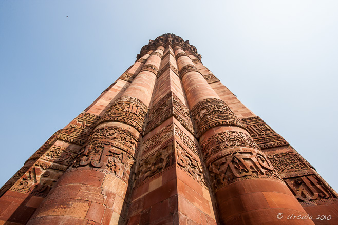
Qutb Minar Look up! India’s 2nd tallest minaret rises 73 metres into the air. (24January2010)
It is pretty impressive: the world’s tallest brick minaret, set in a complex of archaeological ruins dating back to 1193 AD, on a site that is much older than that. The stories behind it are quite something as well.
Qutb Minar, sometimes spelled Qutubor Qutab, was started in 1192 by Qutb-ud-din Aibak, the first Sultan of Delhi and ruler of North India from 1206 to 1210 AD.
Some say Qutb Minar was intended as a minaret for the muezzins to call the faithful to prayer. Others, however, argue that it is a Victory Tower: commemorating the conquest of Mohammed Ghori (Muhammad Ghari) over the Rajputs and celebrating the beginning of Muslim rule in India.
Qutb-ud-din Aibak, the man responsible for having the Qutb Minar built, was born to a Turkish family in Central Asia. Sold as a slave in his childhood, he was lucky that his owners were powerful mentors: the first was a Qazi, a sharia judge, and the next was a Sultan – ruling over Afghanistan, Pakistan, and northern India.
Educated by his first owner, Qutb-ud-din Aibak became a fanatical Muslim. In 1192, under the command of his later owner Mohammed Ghori, Qutb’s garrison occupied Delhi. The young military commander ordered the destruction of twenty-seven Hindu and Jain temples to supply building materials for the construction of Quwwat-ul-Islam (“Might and Glory of Islam”), Delhi’s first mosque. He also started work on the red sandstone and marble tower.
Qutb crowned himself Sultan of the MamlūkDynasty after Mohammed Ghori’s assasination in 1206. Unfortunately, he only ruled four years – dying after impaling himself on the pommel of his own saddle while playing polo. The completion of the giant minaret was left to his successors, who added stories, renovated and repaired damage.
Although the magnificent tower is dedicated to a famous Sufi saint, Qutbuddin Bakhtiar Kaki, it is commonly believed that the name, Qutb Minar, is in honour of Sultan Qutb-ud-din Aibakwho had it built.
In 1993 the whole archaeological site around the minar, including funerary buildings and the remains of two mosques, were declared a UNESCO World Heritage Site.
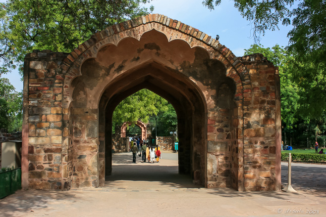
Entrance/Exit A beautiful arched gateway gives an indication of the delicate sandstone carving that is found within the complex. (12April2008)
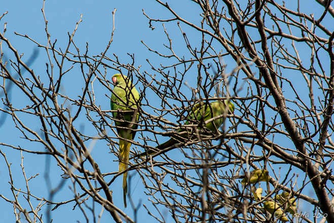
Rose Ringed Parakeets The Mughal Garden and Mughal Mosque are next to the entrance. (24January2010)
Five-Striped Palm Squirrel Once inside the walled Mughal Garden, it is like being in a lost, wild world. (24January2010)
Path to Qutb Minar and Alai Darwaza(2008April12)
Qutb Minar (24January2010)
Alai Darwaza The beautiful domed Alai gate into the mosque complex was erected in 1311 by Alauddin Khalji. The red sandstone structure is decorated with stunning Turkic features made of white marble inlay. (12April2008)
Calligraphy Detail The red sandstone of the Qutb is richly inscribed with Arabic calligraphy. (24January2010)
Young Couple Surfaces everywhere are ornately decorated. (04November 2013)
Great Arch Ruined arches surround the old walls of the Quwwat ul-Islam Mosque. (12April2008)
Carved Colonades Worn columns around the Quwwat ul-Islam Mosque include Hindu motifs, remnants from the temples they were pillaged from. (04November2013)
Alai Minar Sultan Alauddin Khilji, who expanded the Quwwat ul-Islam Mosque, started a second minar, intended to be twice the size of Qutb Minar. He died, however, before the structure rose above the first story. All that remains is a giant rubble masonry core. (24January2010)
Brick Layer The Qutb Minarcomplex requires a fair bit of maintenance. (07April2010)
Brick Layer’s Apprentice On one of our visits, extensive renovations were taking place. (07April2010)
Brick Layer He needs to work fast – the searing heat dries the mortar quickly. (07April2010)
Female Labourer The ring on her head helps her balance the slabs of rocks she must carry. (07April2010)
“Bring your Children to Work” Labourers don’t have access to childcare: children look after each other, while their mums work nearby. (07April2010)
Who could resist that solemn gaze? (07April2010)
Sandstone Detail The housing around Iltutmish’s Tomb is finely carved. (07April2010)
Iltutmish’s Tomb The beautifully carved white marble cenotaph of Iltutmish, the second “Slave Dynasty” Sultan of Delhi (r. 1211–1236 AD) is an important feature within the Qutb complex. (04November 2013)
Photographer in Situ On one of my visits, an Indian woman was sitting outside Iltutmish’s Tomb taking visitors’ pictures with their own cameras. (24January2010)
Indian Woman She was equally happy to have her picture taken – for a tip! (24January2010)
At the Back of the Ruins (04November 2013)
Qutb from the Back Doorways and arches … (24January2010)
Qutb from the Back … make the complex fun to explore. (24January2010)
Security Guard A guard finds a shady spot from which to watch the site… (24January2010)
The Girls … while young women on a day out clamour to have their picture taken. (24January2010)
Young Couple The Qutb Minar site is a popular destination for Delhi residents. This young couple was celebrating a birthday. They even offered me some of the cake they had brought with them! (07April2010)
Imagine: from lowly slave to Sultan and ruler over vast territory, leaving behind buildings still celebrated over 800 years later. Qutb-ud-din Aibak was the founder of a dynasty – albeit a short-lived one (1206 to 1290) – that ruled Delhi and northern India, Nepal, and part of Pakistan.
As hard as it might be to conceive of today, apparently this was not an uncommon practice in early Muslim societies. From the 9th century, Mamlūks (Arabic for “owned” or “property”) were soldiers of slave origin who had converted to Islam. By the 13th century, these Mamluks held political and military power across the region.
Even so, it is an impressive legacy he leaves behind: in stone – and in stories.
Until next time!
Pictures: 12April2008, 24January2010, 07April2010 and 04November 2013
Flag over the Stuart Channel A flag flaps wildly as a sailboat motors through the protected waters of British Columbia’s Southern Gulf Islands.
“Land was created to provide a place for boats to visit.”
-Brooks Atkinson
There are those who sail just for sailing’s sake: for the feel of the wind, the rush of the waves, and the challenge of managing a boat and the elements. As much as I enjoy the physical activity of sailing, I also love it as a means to an end: as a way of being part of the natural environment, and as a way of visiting new locations.
“Travel” takes on a whole new dimension when you are at the helm of a boat on the water. There is a real feeling of freedom that comes with a good day’s sailing: the joy of slicing through the waters towards places that might otherwise be inaccessible.
Of course, in a sailboat, access to those destinations is dependent on the the whims of the winds, the turn of the tides and the sailor’s own abilities. My husband and I get out onto the water whenever we are able, which, unfortunately, is not often enough to make us very good sailors. But, when the opportunity presented to travel with another boat through the tricky Dodd Narrows into the Southern Gulf Islands, we jumped at it. What we lack in skill, we make up in enthusiasm.
We had already been out sailing several days on Graystone, a comfortable 38-foot Hughes (On the Straits and Narrows (Part 1)), so we had our sea legs. Even so, traversing the 60-metre-wide Dodd Narrows had me nervous. Timing is everything: in a sailboat, the Narrows can only be safely crossed under motor and around slack tide. The currents run between 6 and 10 knots, with rips and eddies even during the short slack tide: that six-minute interval, four times a day, when the tide pauses briefly before changing direction.
So, even with careful planning, I was happy to have more-seasoned sailors in a companion boat to keep an eye on us – and to join us in exploring new landfalls.
Into the Narrows The crossing through Dodd Narrows has to be planned carefully to coincide with slack tides.
Sails and Mountains Once through the challenging rips of Dodd Narrows, you are in amongst the Southern Gulf Islands; the potential for exploration is almost limitless.
Thetis Island, a sheltered little gem (2,560 acres ~ 4 sq. miles) across the Stuart Channel from the community of Chemainus on Vancouver Island, is one of those places only accessible by water: seaplane, scheduled ferry, or your own boat.
First Nations people have lived around the area for 8000 years, and Europeans have been settled on the island since the late 1800s. Today, the population stands at 350 people: mostly engaged in managing holiday rentals and Christian church camps. The one-room elementary school has room for up to 50 young children; older students make the daily ferry trips to Vancouver Island. Classified as an “unincorporated community”, the island has no public lands and is self-managed through a special “Islands Trust” administration.
As small as the island is, it’s sheltered location makes it popular with boats cruising in the Gulf Islands. There are two privately-operated marinas. We booked our boats into the smaller of the two, at Telegraph Cove.
Telegraph Harbour Marina The sun lowers in the sky as we settle into our moorings at Telegraph Harbour Marina on Thetis Island.
Shallow Waters The waters around our mooring at Telegraph Bay on Thetis Island are green, shallow, and surrounded by trees.
Night Fisherman We were amused to find an old Asian night fisherman guarding the Telegraph Bay Marina shopfront.
Pennants Flags from yacht clubs around the world decorate the rafters of the barbecue shelter at the Telegraph Harbour Marina.
Jellyfish Like eggs with tentacles, jellyfish float in the waters of Telegraph Harbour.
Dinghy Our travel companions explore the waters of Telegraph Harbour.
Rocky Point The shoreline around Telegraph Harbour is rocky and uneven.
Wildflowers Thetis Island lies in a rain shadow, giving it a mild, relatively dry, climate.
Maple Bay Marina We spend our second night moored at Maple Bay, Duncan, on Vancouver Island. In the morning the light on the waters is stunning.
Towards Crofton Against the backdrop of Vancouver Island, the Crofton Pulp Mill stands out as one of the few examples of industry.
No Wind! It’s slow motoring when the winds won’t blow…
Sheltered from Georgia Strait by the much large Valdes and Gabriola Islands, DeCourcy Island (about 460 acres) feels miles away from the “real world”.
Not only does the island have no ferry service – access is by boat or float-plane only – the only marina is restricted for residents (most of whom are weekenders or holiday stays) only. Property advertisers tout the “Off the Grid Island Life”: the few available house lots need to organise and maintain their own power, water and septic services.
We dropped anchor in the calm waters of the bay at the south end of the island, right next to the 76-acre Pirates Cove Marine Provincial Park.
Anchoring at DeCourcy In the sheltered bay at the south end of DeCourcy Island, we drop anchor for lunch on the boat, …
Dinghy on DeCourcy … then take a dinghy ashore for a walk …
Harbour on DeCourcy … along Pylades Trail, where we have views down over the harbour.
Natures Abstracts: Curling Arbutus Bark
Pine Cones
Grasses The bright afternoon sun glints through the grasses on the hill.
Sailboat From the trail we watch another boat motoring into the south harbour at DeCourcy.
Treasure Chest In order to live up to it’s name: Pirates Cove Marine Provincial Park, a treasure chest full of plastic beads and fake gems sits on the point, not far from the warning beacon and overlooking the boats in the residents-only marina.
Brother XII Trail Brother XII, born as Edward Arthur Wilson in Britain in 1878, was a self-proclaimed mystic and founder of the Aquarian Foundation, a spiritual group – or cult. With money from his many followers, he bought tracts of land on DeCourcy and nearby islands to build a self-sufficient community. Before long, cracks in the planned Utopian lifestyle lead to a series of sensational court battles. He is said to have fled to Switzerland with the Foundation’s money.
Still Waters As we make our way back to the harbour, the still waters of DeCourcy are a sharp contrast to the Dodd Narrows which we must face again – this time travelling north.
Tugboat and Log Boom We sit at the south end of Dodd Narrows, glued to our radios. Working tug boats with their massive log booms get right-of-way, so we wait for our turn.
Log Boom The massive logs are chained together, but you don’t want to get too close – and you really don’t want to meet a log that has broken free!
Twilight Daylight is fading as we chug north through Newcastle Island Passage to Nanaimo.
Nightfall
On the way back to our mooring, we learn the truth of another sailing axiom attributed to Francis Stokes: “The sea finds out everything you did wrong.”
For, it turned out our running lights were not working. Like an old-fashioned figurehead, or Kate Winslet in the Titanic, I stood at the prow of the boat with a flashlight, making sweeps across the dark waters in front of us, tying to see and be seen. Even at night Newcastle Island Passage is busy with tugs, fishing boats and the massive BC Ferries.
It was with a relieved sigh we found our “home” berth and tied up safely, had a quick drink at the local pub, and reflected on another great sail – and some great landfalls.
Candle ~ Kaiyuan Temple ~ Quanzhou Red, symbolising fire, is the colour of good fortune and joy in China. It is also wonderfully cheering on a gray, overcast day.
My husband is in China at the moment.
I am not. Such is life!
I shouldn’t complain too much; his absence gives me extra time to get to photos I haven’t yet processed… including those pictures I took when I tagged along on his last trip to China in April. We stayed in Xiamen (Amoy): regularly rated highly among China’s most-livable cities. It is a university town, with a lot to offer visitors (Watch this space!).
So, I could have cheerfully spent more time there. One day, however, my husband had to make the one-hour-plus trip to nearby Jinjiang, and I had the option to tag along. Not one to pass up an opportunity, I jumped at the chance.
“Why would you want to come to Jinjiang? Why don’t you stay in Xiamen?” asked one of my husband’s Chinese colleagues. “Even the locals are leaving!”
It is true: Jinjiang, Quanzhou, Fujian, in southeast China (not to be confused with Jinjiang, Chengdu, Sichuan, in the southwest – or any other Jinjiang that might exist in China) is known more for the large number of factories operating thanks to foreign-investments – manufacturing clothing and name-brand footwear, predominantly – than for its tourist appeal. The area attracts migrant labourers from around Fujian Province and beyond, who come to work on one-year contracts, often staying in barracks-like dormitories with few amenities and minimal landscaping. Bleak.
But, I like to visit places that are not necessarily on the main tourist trails. I enjoy being a traveller rather than a tourist. And – not that I “pull rank” – there is a real advantage in being a visiting-boss’s wife. I wasn’t left entirely to my own devices: I was given a driver for the day, and the driver was given a list of places of interest which mostly coincided with the places I had hoped to see. My lack of Mandarin and the driver’s lack of English meant that the list ruled, and I went where I was led.
Most of the places we visited were not in Jinjiang, but back across the river in Quanzhou.
Rubble The outskirts of Jinjiang are replete with buildings coming down; work projects that have started and stalled.
High-Rises, Quanzhou High-rises, low-rises, and concrete blocks – all under a gray sky that always feels like winter… This is one of the prevailing mental images I have of my times in China. As we cross the Jin River, a modern metropolis comes into view.
Quanzhou Longshan Temple Built in the Sui (Xiyue) Huang Thai years (618-619), this temple complex is so important to the faithful that many who have migrated out of Jinjiang and Quanzhou (especially to Taiwan) make regular pilgrimages back.
Lanterns and Inscriptions in the Eaves Since this temple was built, other temples called “Longshan” have been constructed by migrants from Fujian Province to other parts of China and Taiwan. The first Longshan Temple in Taiwan was built from materials imported from Jinjiang.
Candles and Prayers Visitors to the temple worship a mixture of Buddhist and Taoist deities.
Courtyard It is hard to tell new buildings from old in the inner courtyards. Memorials to deceased ancestors line the side of one building.
Dragon on the Roof The dragons and round roof tiles are such a distinctive feature of traditional Chinese architecture.
Prayers Years of strict communist rule don’t seem to have impacted on the desire to pray for good fortune or guidance – even among the young.
Prayer Beads and Bobbles Talismans with Buddha images and carved prayers are readily available…
Religious Shop … as is anything else you might need for your religious practice or study.
Joss Sticks Burning There was smoke in the air and plenty of activity as we arrived at nearby Guandi Temple.
Guandi Temple This large, ornate, Taoist temple is busy with local people coming to pray.
Revered General Guandi Temple is dedicated to two Chinese generals, Guan Yu and Yue Fe.
Ritual Furnace Guandi Temple is known for the huge furnace designed for the ritual burning of joss paper.
Burning Joss Paper
Furnace Detail
Entry Our next stop was at the 1000-year-old Qingjing (Ashab) Mosque.
Roof Detail The mosque was restored in 2009. The clean lines and subdued colours of the the Arab-style building are in distinct contrast with the nearby Chinese temple architecture.
Crypts ~ Ashab Mosque During the Song Dynasty (960-1279), Quanzhou was a key foreign trade port and was home to a large international community: including Arab, Persian, and Indian Muslims.
Ancient Stonework ~ Qingjing Mosque The local Arab Muslim community maintains the mosque’s heritage and buildings.
Bombax Ceiba Back outside, the flowers were falling off the red cotton trees.
Lunch Set Our next stop was at a wonderful noodle shop, so dark I couldn’t have read the menus even if they had been in English. I ended up with a delicious, fragrant broth with broccoli and lotus root – and did my best to ignore my upbringing and slurp appreciatively.
Stonework ~ Kaiyuan Temple Delicate stonework decorates the walls around Fujian Province’s largest Buddhist temple complex.
Zhenguo Pagoda The Twin Pagodas at Kaiyuan Temple are the highest of China’s stone pagodas.
Door Handles A pair of marvellous creatures guard the entrance to the Zhenguo Pagoda.
Gardens ~ Looking towards Reshou Pagoda The grounds in the Kaiyuan Temple compound are beautifully landscaped and maintained.
Mahavira Hall Kaiyuan Temple was originally built in 685 or 686 during the Tang Dynasty. In the late 13th century, it was taken over by the Tamil Hindu community. Parts were rebuilt and dedicated to Lord Shiva. It was designated a national temple in 1983.
Buddhas in the Hall of Mahavira
Story Tiles One of the buildings is covered in delicately painted stories…
Story Wall … while elsewhere, carved panels tell tales.
Bells Mid-afternoon, we drove back across the river to Jinjiang, and up an impossibly steep and bumpy dirt road of blind corners and switch-backs to what was to be the penultimate stop: a modest modern temple perched on a cliff. The bells on the stone pagoda send prayers to the skies and overlook the factories below.
Tea with the Monks Jimmy the Driver and I were invited inside to have tea. I think Jimmy and the monks are old friends.
Making Tea Each small pot of tea took time, as the leaves were packed into the little pot…
Green Tea … and the water was poured. The leaves were left to steep before the tea was strained into a glass pot, then served in small glass cups.
It’s those moments: sharing tea with monks, that make travelling with locals so precious. The hot tea perfectly capped off a damp, but richly rewarding day. My face was sore from smiling – both from enjoyment and from the need to communicate non-verbally.
The irony is that I wanted to send a little something back with my husband for the driver, to express my appreciation for a day well spent. When we looked for souvenirs, the only reasonably-priced “Australian” trinkets we could find were “Made in China” – and quite possibly made in Jinjiang!
je echtgenoot is in China en dat geeft je extra ruimte. Mooi, zo kunnen wij van een heerlijk blogbericht van je genieten. En dat heb ik, genoten van je bericht en foto’s. Lieve groet, DietmutReplyCancel
Rice Seller Another day in Southeast Asia, another market… another opportunity to meet and photograph the people.
“Same, same… but different.”
This common Thai expression is one that perfectly sums up my perception of markets in Southeast Asia: they are the “same”, in that they are all densely packed environments full of colours, people, sounds, smells and (usually) oppressive heat. Often wet and uneven underfoot, they are a warren of activity that can be overwhelming for the visitor.
Photographically, they are a challenge: the light is almost always tricky, with streaks of bright sunshine contrasting starkly with dark, shaded corners. Shade-cloths in ghastly green and bilious yellow cast unwelcome hues across the faces of the customers and vendors.
One morning on my trip around Myanmar – two years ago now – with Photographer Karl Grobl and local guide Mr MM, we stopped at two local markets. I’ve checked my notes, and beyond knowing that we were in the Bagan area somewhere, I have no idea which markets we were in. But, as is the case with most markets I have visited, the faces were open and the people were willing to be photographed.
Distilling Whiskey The first “market” we stopped at was little more than an elaborate bamboo shelter. Some local crafts and coconut products were on sale, but the main purpose seemed to be the distillation and sale of local whiskey.
Man with Metal Pot The whiskey maker in his longhi proudly shows us one of the local pots.
Whiskey-Medicine Bottles The whiskey is bottled with some sort of dried wood, and used medicinally.
Taste-Testing Local Whiskey You can sample the wares before you buy.
Whisky Vendor I passed up the taste-test: it was not yet ten o’clock in the morning, and the day was already searing hot and bright. Even a small shot of local brew would probably have finished me off!
Man with Straw Flower Grasses are woven into flowers, insects and birds for sale.
Straw Flowers
Girl Eating Breakfast Families live and work together. While the whiskey is cooking, a young girl eats her rice.
Burmese Girl
Cow at the Mill Just outside, in a spot of dappled shade, an older man supervises a bovine-operated millstone.
Man and his Cow The old man is happy to be photographed; the cow, a little less so.
Our next stop was at a “city” market, nestled into the Bagan streets. A much more structured complex, with brick walls and roofing of wood, woven bamboo and plastic sheeting, this market with its large bags of rice and other grains piled high, targets bulk-buyers.
Selling Grain The buying and selling of grain is a serious business.
Checking the Rice Purchasers check the quality of the products carefully…
Negotiating … and haggle over prices and quantities before recording sales.
Bags of Rice
Rice Sellers Women smile at me as the deals are entered into the books.
Apothecary In a shop full of arcane herbs, a man stands ready with his scales.
Market Portrait A typical burmese woman: thanaka powder on her face, flowers in her hair, and a big smile for the visitor.
Man in the Tomatoes Wearing his white shirt and longhi, with traces of Betel nut around his mouth, a typical burmese man gives a smile for the camera.
The Canopy The green tarp over the roadways between the buildings casts a sickly light over the products and merchants inside.
Hands at Work It is fascinating people-watching in the markets; they alternate effortlessly between activity …
Man in the Market … and ease.
Market Portrait Another typical smiling burmese woman in her thanaka powder.
Young Man in the Market
Another Gorgeous Smile
Outside the Market In a dirt street outside the main market, young workers push an empty trolley away.
I could always stay longer in any Asian market…
I spend very little money, and the smiles are always free. Perfect, really.
The Marie-Louise Reservoir There is a natural beauty in this old reservoir, dug out of the Bex countryside by hammer and chisel in the 1800s.
Salt.
“Worth ones salt.” To be of value; worth ones pay. The English word “salary” comes from the Latin salarium (where sal is Latin for salt), thought to have been the allowance given to Roman soldiers to buy salt.
Since time immemorial, salt – sodium chloride (NaCl) – has been recognised for its critical importance to the life of humans and animals alike. Before the invention of canning and refrigeration, salting food was the principle means of preserving it.
“You [good Christians] are the salt of the earth”, Matthew (5:13) attributes to Jesus, where salt is a preserver, an enhancer – necessary to a healthy life.
So, in the days before a salt shaker on every table, where did people acquire this essential commodity?
In coastal areas, salt can be mass-produced by evaporation of seawater or brine from brine wells and salt lakes (see: Salt! Samut Sakhon, Thailand).
In regions away from the sea, it has to be imported, or mined – which, prior to the Industrial Revolution, was a difficult and dangerous task, often performed by slaves or prisoners. Hence, the expression: “back to the salt mines” for the return to an arduous or unpleasant job.
Why my preoccupation with salt?
Well, we were in the Swiss Alps this summer and meant to be walking among the peaks and meadows… But it rained. And rained. We were staying in a tiny village that didn’t offer a lot of bad-weather recreation, so – on the advice of a local – we hopped on a couple of trains and took ourselves to the nearby municipality of Bex for a tour of the Bex Salt Mines. That way, our informant told us, we’d be out of the wet!
Switzerland is, of course, land-locked. Before the discovery of salt deposits near Bex in the 15th century, the precious substance had to be transported from foreign suppliers over the mountains at great expense. The finding of the salt springs is attributed to a local shepherd, but it was the Bernese invaders to the region who, in 1475, started boiling the water from these slightly saline springs, rendering the salt through evaporation.
Excavation of the springs began in ernest in 1684. Over time, periodic digs resulted in the vast maze of passages, shafts, stairs and gigantic caverns, extending almost 50 kilometres, under the villages of Villars, Chesières and Arveyes, that exists today. The mine still operates, producing salt and salt-based products as well as generating electricity. It also operates as a historical tourist facility and a function centre.
After we arrived at the Bex Railway Station, I tested my French and procured two coffees and a map. The skies cleared sufficiently, so with our raincoats and umbrellas, we set off through the town and along the cross-country walking trails to the Salt Mines.
Central Street in Bex A typical small Swiss town view: hanging flower baskets, a church spire, and quaint roofs – and mountains as a backdrop.
Le Temple de Bex Built on the site of a 12th century Catholic church dedicated to St. Clément I, the Protestant church that now commands the centre of town was started in the 16th century – after the Reformation.
House on le Grand Eau The land was green and wet as we walked along the Avançon River.
Sculpture Garden As we continued into the hills, we came across an unmarked garden, dotted with sculptures.
Into the Woods Soon we were off the roads and onto the pathways. The chip-bark underfoot was lovely – especially given the wet weather, and some of the very steep inclines.
Chemin Randonnée Pedéstre Coming across signposting is always encouraging, especially as the walk was much longer than we were led to believe: 8 kilometres rather than 5-6, and rather hilly.
Vous êtes le sel de la terre – Matthieu, V-13-16 Ainsi soit-il et respectons la peine d’autrui, les cultures, la vigne et le dur ouvrage de nos ancêtres. You are the salt of the earth – Matthew, 5:13-16 So be it and respect the worth of others, crops, vines and hard work of our ancestors.
Cow in the Vines The low-toned chimes of cow bells greeted us as we commenced a long traverse across the vineyards after coming out of the woods.
Vinyards As we walked around the hill, we had views over the valleys and villages of Vaud.
Mine Entry Finally! We came out of the vines, through more woods and down into the Bex Salt Mine, in time to pick up the tickets we had booked by phone, and wait for our guide. Tours frequently sell out – especially in wet weather.
Reservoir Rond After we take our seats in The Round Reservoir we are shown a 15 minute video about the history of the mine – in French with difficult-to-read subtitles in German, Italian and English.
Reservoir Marie-Louise The second chamber we entered was the beautiful Marie-Louise Reservoir. The giant 1,500 cubic meter cavern, supported by columns, was named for Empress Marie Louise of France, Napoleon’s second wife. She visited the site in 1814 after Napoleon was already in exile.
Looking Down the Shaft Started in 1743, the digging-out of the 215 meter-deep Bouillet Shaft took 26 years of manual labour using only hammers and chisels.
The Train We all climb into small train carriages at the Gare de Puits and the trains take us 1500 meters to the heart of the mine.
Tunnels When we alight the train, more tunnels lead through the mine…
Trolley … past anhydrite (dehydrated gypsum) walls and old utensils.
The Wine Cellar The temperature in the Salle René Burnier is a stable 17° C all year round, making it a perfect place for the local vintners to store the fruits of the local harvest – under lock and key, of course.
Stairs More stairs wind down to the Salle des Gradins…
Salle des Gradins … where our guide explains the workings of the modern drill systems.
Salle du Talon Old lamps, with examples from the 15th …
The Museum … to the 20th C, hang on display.
Miner’s Locker The Salle du Talon includes an authentic miner’s locker room. In the next rooms, the Puits de la Tranchée, examples of the tools used by the various craftsmen involved in salt extraction and production are laid out on show.
Salt There are various displays, artworks, exhibits, and interactive activities for the children.
Train The tour lasts two hours, but it doesn’t seem that long. Soon it is time to get back into the train carriages and return to the surface.
Into the Storm Laden with fragrant salts we had purchased from the crowded shop, we walked back to the train station via the roadways, saving time and distance – making it back just before the skies opened once more.
It was an enjoyable and educational experience – one I’d highly recommend.
It certainly beat walking in the alps in the rain!
- Performing the Ganga Aarti from Dasaswamedh Ghat, Varanasi
- Buddha Head from Shwedagon Pagoda, Myanmar
- Harry Clarke Window from Dingle, Ireland
- Novice Monk Shwe Yan Pyay Monastery, Myanmar
Packets of 10 for $AU50.
Or - pick any photo from my Flickr or Wanders blog photos.


 It was with a relieved sigh we found our “home” berth and tied up safely, had a quick drink at the local pub, and reflected on another great sail – and some great landfalls.


 The irony is that I wanted to send a little something back with my husband for the driver, to express my appreciation for a day well spent. When we looked for souvenirs, the only reasonably-priced “Australian” trinkets we could find were “Made in China” – and quite possibly made in Jinjiang!


 I could always stay longer in any Asian market…


")
