Rajasthani Gypsy Dancers Flickering light from a small fire in the temperate desert night, the haunting sounds of Indian woodwinds and syncopated drums, swirling dresses and rising song: it is a gypsy performance under the stars – guaranteed to make you smile.
Cool sands underfoot. Starry, wide-open skies overhead. Firelight and music and drums.
There is magic in the desert air.
“Midnight at the oasis Send your camel to bed Shadows paintin’ our faces Traces of romance in our heads…”
– Midnight at the Oasis by David Nichtern for Maria Muldaur
It was nighttime in the middle of the Thar Desert.
The Great Indian Thar Desert in northwestern India forms an expansive boundary with Pakistan. Also called the Marusthali, or “Land of the Dead” in Sanskrit, the region is none-the-less rich with its own unique life. My travel companions and I, with photographer Karl Grobl and local guide DV, had spent a fascinating day visiting with villagers in the heart of the arid, rolling dunes (see: Everyday Life in the Great Thar Desert), and were now reclined on chairs set deep into the sand.
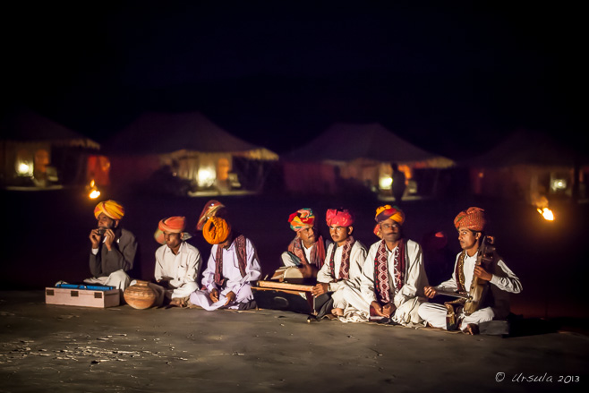
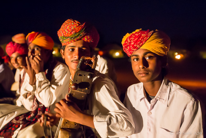
Camels snorted in the shadows. The soft lamp-light from the tents in the background didn’t reach the low tables in front of us as we snacked on spicy nibbles we could barely see. Seated cross-legged on a concrete “performance space”, Rajasthani Kalbelia or Kabeliya men entertained us with the traditional music of the nomadic desert tribes: music played on the morchang, or jaw-harp; the sarangi, the most important stringed instrument in north-Indian folk music; the dufli or daf, a goat-skin tambourine; and various percussion instruments, including the dholak, or two-headed drum.
Rajasthani Gypsy Musicians Seated on the concrete “performance space”, musicians entertain us with plaintive melodies and syncopated beats.
Rajasthani Gypsy Musicians
Family of Kalbelia Dancers “Back stage”, two Kalbelia gypsy dancers and their young brother pose for pictures.
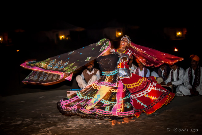
In the darkness behind the musicians, the evening’s “main attractions” – two Kalbelia gypsy dancers – were getting ready for their performance. With their younger brother and apprentice musician, they paused for photos in the dark, before their entrance onto the stage.
The songs and dances themselves are part of an oral tradition based on stories taken from folklore and mythology, and handed down through the generations. But neither the dances nor the songs are codified: the Kalbelia have a reputation for composing lyrics spontaneously and for creating improvisations between the dancers and the musicians.
Kalbelia Dancer The dancer weaves to the rhythm of the music – and the musicians follow her lead.
Gypsy Dancer In a swirl of skirts, with feet flashing, the dancer twirls…
Kalbelia Sisters … before being joined “on stage” by her sister …
Kalbelia Sisters … and spinning together with her. The flowing skirts are known for their intricate embroidery with silver thread and small mirrors.
Fire in the Foreground
Musicians Performing A male performer, keeping time with his rhythm sticks, sways gracefully as he sings traditional songs of the Bhopas, the another nomadic tribe. His companions accompany him on a matka, an earthenware pot; and a morchang, the plaintive desert mouth-harp.
Gypsy Backbend Kalbeliyan dancing requires a balance between suppleness and strength. When the women come back, they demonstrate their flexibility. The younger sister performs backbends …
Collecting Money … picking up money with her teeth.
Gypsy Backbend The elder sister goes one better …
Pick-up-Rings … and picks up rings with her eyes.
Portrait of a Dancer
Dancers Spinning Hands twisting gracefully, skirts flying, the sisters circle and spin…
Dancers Spinning … until they almost disappear.
Swirling Fabric
Dancer in Abstract
Black Swirl
A Dancer’s Smile
“… You don’t have to answer There’s no need to speak I’ll be your belly dancer, prancer And you can be my sheik.”
[…] crackles with heat and hope, where life is hard (Life in the Thar Desert) and the nights are magic (Music and Magic). A place where, in the late afternoon, watching some men and their camels on the crest of a sandy […]ReplyCancel
[…] We headed back to our camp for a dinner and entertainment under the stars: the nights are filled with traditional gypsy folk music and dance (Celebrating Music and Motion). […]ReplyCancel
Temple on Taung Kalat – Pedestal Hill Popa Taung Kalat Monastery sits high on top of a volcanic plug in the Mount Popa National Park. Traditionally, the Mount Popa area is the most important home of the Nats – Burmese spirits.
Nats (နတ်), or spirits, have been a central part of Burmese life since time immemorial.
Nats are everywhere in Myanmar: they are in the trees, the wind, the stones and the waterways. They act as personal and village guardians, but can be troublesome if not properly propitiated. Every Burmese village has a shrine to curry favour with the local Nats; ritualised offerings are hung in houses; amulets are worn; and car rear-view mirrors are festooned with talismans to ward off mischief. Festivals to appease the major Nats are held regularly.
Part of a rich heritage of early animist religions in the Burmese countryside, Nat worship predates Buddhism. When King Anawrahta of Bagan (1044–1077) first introduced Buddhism into Myanmar, he tried to ban the worship of the old spirits. However, his attempts backfired, and Nat worship was simply driven underground. Clever enough to recognise his failure, he decided to incorporate a hierarchical pantheon of 37 Great Nats – also known as the Mahagiri Nats – into the local Buddhist practice. The chief of these Nats is Thagyamin Nat (the Indian god Indra, protector of royalty) and the others are ghosts or spirits of dead Burmese heroes, many of whom were killed prematurely. All of these principal Nats are known nation-wide. They have their own personalities and histories; many have their own ceremonies and festivals. Nats are not saints or angels. They have the same human characteristics and flaws as they had in life, and they are often angry or jealous of the living. So, while the Burmese might ask the Nats for good fortune, they are also concerned with appeasing them to avoid harm.
Mount Popa, a long-extinct solitary volcano standing out from the dry plains of Central Myanmar, has long been designated home of the Nats. Four kilometres from the main peak is one of Myanmar’s most sacred places: Taung Kalat (Pedestal Hill), an incredible magma plug rising straight up some 170 – 180 meters from the surrounding rock and jungle. The Popa Taung Kalat Temple, a Buddhist monastery and pilgrimage site, including shrines to all 37 Nats, perches precariously on the summit.
What we did do, however, was equally fascinating: starting with a visit the Mahagiri Shrine at the foot of Mount Popa.
Mahagiri Shrine Hawkers, with their baskets full of offerings for the spirits and snacks for the pilgrims, congregate out the front of the colourfully decorated Mahagiri Shrine – a temple at the base of Mount Popa dedicated to the 37 principal nats.
Flower Seller Inside the Mahagiri Shrine, a young girl sells garlands, intended as offerings to the spirits.
Three of the 37 Nats King Anawrahta of Bagan designated an official pantheon of 37 Great Nats.
Offering Nats are very human in their desires: gifts to them include alcohol, cigarettes, goods, flowers, and money. Money they have blessed is considered especially lucky.
Locals on the Stoop Rhesus macaques have run of the town of Popa.
Rhesus Macaque Although very cute, the monkeys expect their share of “offerings”.
Rhesus Macaque
Popa Mountain Resort We lunched at a wonderful resort …
Playing the Saung … with traditional burmese harp music …
Temple on Taung Kalat (Pedestal Hill) … and amazing views of the Buddhist temple that perches on the top of the volcanic plug at the Southwest of Mount Popa.
Each of the 37 Great Nats was, in at least one of their previous incarnations, associated with members of the royal family; Nat worship therefore, affords commoners some protection against misfortune.
As we discovered in a nearby rural village, it does not, however, bring electricity or running water.
Children at the Window At a small school near Taung Kalat …
Teacher Marking … children study and teachers work without the benefit of electric lights or fans.
Child at the Schoolhouse Window
Kids in the Classroom
Cow in the Barn In spite of the lack of modern conveniences, this rural village is neat and tidy.
Man on the Stoop The community has received a recent injection of funding, and some of the buildings are quite new.
Woman in the Barn Workers always seem happy to take a moment out …
Chopping Grass … from monotonous manual labour …
A Burmese Smile … to flash a brilliant smile for the camera.
Old Burmese Man A community elder pauses to take stock of the visitors …
Old Man … and to pose.
Piglets in the Yard A mainstay of any “rich” tropical community, pigs are the perfect grain-storage units in damp or rainy climates where grains grow mouldy quickly after harvest.
Young Girl Not all the children are in school –
Village Children – and those running loose in the dirt are happy to have their pictures taken.
Young Boy
On the Dirt Path A woman from the village carries laden water buckets home in the afternoon light.
Although some people say that Nat worship is dying out, this is more true in the developed, urban centres. In fact, the many annual Nat Festivals are still well-attended – and it is easy to see why rural people would want some surety in their uncertain and labour-intensive days.
It’s a hard life. I hope the Nats can help people make the necessary transitions into the modern world.
I’m not sure of the date, but it’s old! One legend goes back to the 6th century B.C, and Maung Tint Dai, a blacksmith in the Tagaung Kingdom.ReplyCancel
Simple Treasures Yellow treasure flowers (Gazania rigens) bring cheery brightness into any day; they might be native to Africa, but they are perfectly at home in the sandy soils at the ocean’s edge in South Australia.
It is easy to hit over-load while travelling: too many wonderful sights, engaging activities, interesting people, and novel tastes and smells… This can be especially the case after spending time in an environment so sublime that it transports you, producing a nature-induced “peak experience”.
We had just driven the length of Australia’s Great Ocean Road, a drive through scenery so magnificent that it rates its own UNESCO World Heritage listing. Anything after that was bound to be anti-climactic!
But, we still had 620-720 kilometres – depending on the route we chose – to drive to Adelaide. So, with some trip-notes printed from the internet in hand, we took a deep breath, left the Great Ocean Road behind us, and pointed the car northwest.
South Beach and Pea Soup Cove, Port Fairy The Great Ocean Road slipped away with no fanfare; by the time we reached the charming seaside town of Port Fairy, it was already half an hour behind us. Our first brief stop was for a breath of salt air overlooking the pounding turquoise waters.
Seagull, Port Fairy It was late afternoon, with a tearing wind, as we watched the gulls swoop on the drafts.
Windmills I couldn’t resist an iPhone snap out the window as we headed northwest across a golden rural landscape, replete with windmills. (iPhone 4S)
The Umpherston Sinkhole Early next morning in Mount Gambier, South Australia’s second largest city, we took the time to explore some of the local attractions. Sitting on the side of the volcano of the same name, Mount Gambier boasts craters, sinkholes and caves. This one, the Umpherston Sinkhole, is a collapsed limestone cave that was first landscaped and planted by James Umpherston in 1886.
Sheoak (Casuarina) Overhead The sinkhole garden is planted in layers, with trees overhead…
Young Grape Leaf … foliage and flowers around the upper rim…
Ivy … and thick curtains of ivy tumbling down the sides.
The Umpherston Sinkhole The shadowed gardens at the bottom of the sinkhole include a fountain, slow-growing tree-ferns and colourful hydrangeas.
Blue Lake One of Mount Gambier’s most popular attractions is Blue Lake, the extinct crater, filled with high-quality artesian drinking water. We were lucky: the colour of the lake changes with the seasons, being a steel grey in winter. Sometime in early November each year, it changes – almost overnight – to the spectacular cobalt blue we were treated to. Late February the colour gradually returns to its winter grey.
“Waawor” The 3.6 kilometre walking circuit around Blue Lake – Waawor in the indigenous Boandik language – includes information signs and viewing points.
Blue Lake Not yet noon, the day was already crackling with heat. Some of the foliage around the lake was clearly suffering from the recent dearth of rainfall and unusually high temperatures. The city of Mount Gambier can just be seen on the horizon.
Purple Flower The hot, dry air hummed with insects and birdsong.
Flowering Trees The hot air was also filled with the delicate scents of the native blooms.
Cactus Garden A local group of cactus enthusiasts maintain a fenced and gated private garden of large cacti.
Rook Wall and Lookout At the tail end of WWI, the Mount Gambier District Progress Association came up with a plan to do something for the town. Thanks to 1100 local volunteers (800 men and 300 women), in only one day the dolomite and limestone wall and lookout were predominantly finished. The feature was named for Mr. Arthur Rook, local publican and chair of the planning committee, who died prematurely from the Spanish flu in 1919.
The Pumping Station The old Pumping Station, built from cream and pink dolomite in 1884, and extended in 1909, nestles across the Riddoch Highway from the Rook Wall.
Beachport Surf Beach Our next stop was just east of the coastal town of Beachport to marvel at the colours and the expanse of empty beach.
Beachport Surf Beach The surf beach, stretching in both directions, was almost deserted.
Beachport Jetty Beachport is widely known for the long Beachport jetty; a steel screw pile jetty built between 1878-1882.
The Jetty Originally 1220 meters long, the jetty still extends 772 meters into Rivoli Bay, making it visible on the horizon, even from a distance.
Whaling Monument On the north side of Beachport is a cairn commemorating the area’s first white settlement: a whaling station established here in 1843.
Echidna As we continued along the Southern Ports Highway, we had to stop the car to let a spiny anteater waddle across the road. I was prevented from taking a great shot by: 1) the speed at which the little creature moved, and 2) the searing heat of the pavement on my bare feet!
Customs House, Robe The coastal town of Robe was declared an official port in 1847, shipping wool and receiving boatloads of Chinese immigrants heading to the Victorian goldfields. The Customs House was built in 1863 and was managed for many years by pioneering shipping agent George Omerod.
The Coorong Our last, late afternoon stop before hitting the highways into Adelaide, was overlooking The Coorong: a string of saltwater lagoons at the mouth of the River Murray. Shielded from the Southern Ocean by the Younghusband Peninsula, the area has international importance as a wetland, as well as deep cultural significance to the local Ngarrindjeri people. It was hot – breathtakingly hot – and the brackish smell that spoke of salt-water organisms dying, was overwhelming.
We could have spent days at each of our brief stops. What a fascinating, beautiful stretch of road, rich in scenery and history.
One day, we’ll be back – with the time to explore properly!
Sumatran School Child A group of school children were on an excursion to the crocodile farm at Asam Kumbang near Medan, where we made our first road stop of the day.
Some time ago – last April, to be exact – I wrote about the breathtakingly awesome experience of meeting Sumatranorangutans in their wild jungle habitat (Ursula’s Weekly Wanders: Meet the Locals). Truly, it was a memorable encounter – one not easily matched.
It was hard to leave the Gunung Leuser National Park, but our itinerary called for us to move on. And, much of the overall impression of any trip comes from the smaller things: the insights into day-to-day life, the “ordinary” landscapes, and the people you meet along the way, as you travel from one place to another (q.v. Ursula’s Weekly Wanders: Medan to Bukit Lawang).
We were driven by car from Bukit Lawang back to Medan,and then on to Berastagi in the foothills of the Barisan Mountains: three hours according to Google Maps; closer to twice that according to my trip notes.
Taman Buaya: Crocodile Farm Our first road stop was at Indonesia’s largest private crocodile farm near Medan. The crocodiles bred here can not be exported or sold, so the owner must feed them from the entrance fee. This probably accounts for the crowded and run-down nature of the place.
Sumatran School Children A couple of classes of school children were at the “farm” when we visited. With her pen and notebook in hand, a schoolgirl climbs up on a vantage point to better see the crocodiles in the swamp.
Schoolgirls Her smiling friends below wait their turns to climb up to the fence.
Crocodiles in the Swamp In the swamp, the crocodiles are almost invisible, …
Crocodiles in the Swamp … hidden by the algae until they lift their heads.
Sumatran School Girl A young girl sits in front of the fence around the swamp.
School Children at Lunch More girls, in their school uniforms, sit in some shade eating their lunch.
School Boys at Lunch In another corner of the hot, concrete yard, the boys find a patch of shade for their break.
Sumatran Baby After the crocodile farm, we drove back to Medan, where we took our coffee break in the home of our local guide, …
North Sumatran Baby and Dad … and met his young son.
Santa Maria Annai Velanghanni Our next stop was at Santa Maria Annai Velanghanni. Built in 2005 in Indo-Mogul style, this extraordinary building is a Catholic temple.
“Our Lady of Good Health” The shrine is a devotion to Mary, who was said to have appeared in the 17th century in Velanghanni, Tamil Nadu.
Medicinal Bats? We then stopped briefly at the side of the road where bats were being kept – reputedly as medicine for asthma.
Woman with Cinnamon Bark Our last stop was at a mixed small farm holding, where cinnamon, from the bark of the cinnamomum burmannii tree, was one of the products being harvested.
Shaving Cinnamon An inherently sustainable crop, cinnamon trees grow easily, …
Shaving Cinnamon …albeit slowly, and can be intercropped with other plants.
Young Coffee North Sumatra has the perfect soil for Arabica coffee. Most of it, too, is grown by smallholders.
Cocoa for the Picking One of Indonesia’s most important agricultural export crops: cocoa, is another product predominantly grown by smallholder farmers.
Dried Cocoa With rumours of an impending shortage, cocoa is a lucrative crop.
Spilt Cocoa Ironically, the government’s attempt to promote value-added processing industries by taxing the export of cocoa beans puts pressure on small growers.
Pineapple The beauty of cinnamon, coffee and cocoa – unlike the rubber and palm oil mono-plantations that are threatening the local orang-utan habitats – …
Cassava or Tapioca … is that these basic food crops can be mixed in with cash-crops.
Gruyères Castle Courtyard The medieval castle that comprises the old town of Gruyères, in the upper valley of the Saane River, is a popular Swiss tourist spot.
A castle, cheese, wine and chocolate: what’s not to love about Gruyères?
We were meant to be hiking around Leysin in the Swiss Alps, but it was raining, and had been for days. We went through the guide books and asked locals about alternative amusements (q.v.: A Trip to the Salt Mines). The medieval town of Gruyères was three train-hops away from our accommodation; so, with our Swiss Rail Passes and our umbrellas in hand, we set off to visit the home of the well-known cheese.
Three trains (Leysin-Aigle, Aigle-Montreux, and the seasonal “Chocolate Train”: Montreux-Gruyères) and two-plus hours later, we arrived in Gruyères. It was still raining.
Gruyères is in the French-speaking part of Switzerland, which usually makes my task easier – as my patchy French is better than my fledgeling German. According to the books, the Gruyères train – dubbed The Swiss Chocolate Train – would also take us to Broc, home to the Maison Cailler, a chocolate factory which offers tours. Unfortunately, the attendant at the Gruyères railway station was less than helpful – in any language! We watched him give short-shrift to some Indian visitors who spoke impeccable English, before getting no help from him in French or English ourselves. Travel is not without its moments of uncertainty.
So, we decided to hedge our bets, and walked up to the Château de Gruyères before travelling further.
Up to the Castle After our three trains, we had a fifteen minute walk up to the Château de Gruyères.
Through the Castle Wall Built between 1270 and 1282, Gruyères Castle is one of the most important medieval cities in Switzerland.
Young Lovers What could be more romantic than a stolen kiss on a medieval battlement wall?
Inside the Castle Walls The castle was bought back by the canton of Fribourg in 1938, and is currently maintained by The Gruyères Castle’s Friends.
In the Entry Wherever there are tourists, you will wait a while for a clear shot! 😉
The City Crest The crane (“grue” in French) in the crest gives Gruyères its name.
Castle Courtyard We were pleased to discover the range of shops, museums and restaurants inside the castle walls.
Jesus over the Doorway In the centre of the castle courtyard, an old chapel …
Egg Painter … now houses artisans working, …
Turkey Eggs … and crafts for sale.
Museum HR Giger Since 1998, Château St Germain has housed the official museum of Hans Rudolf Giger, the surrealist Swiss artist responsible for the Academy Award winning design work on the movie Alien.
St.Theodul Church Looking outside the walls of Château St Germain, one of the two castles in Gruyères.
Le Château de Gruyères Looking up at one castle – Château de Gruyères – from another – Château St. Germain.
Wall Plaque Giant metal plaques decorate the entrance to Castle of Gruyères; this one is on the left wall.
Old Armour Gruyères Castle contains many old artefacts and has been refurbished as a museum.
The Garden A formally sculpted French garden is maintained behind the château.
Paintings Gruyères Castle hosts regularly-changing exhibitions by modern artists.
Put me in a Swatch It wouldn’t be a Swiss town without a Swiss watch shop!
Fait à la Main Finely woven linen, with delicate pulled-thread-work decoration, is on display in another shop.
Walkway to Gruyères After a lunch that mainly consisted of – you guessed it – cheese, we walked down to the new town. Visitors were still walking up to the castle through the mist and rain.
La Maison du Gruyère “The House of Cheese” beckons through the wet…
Watching Cheese Making Safely inside, we head to the upstairs viewing area where wall plaques and audio-guides explain all about making the famous Gruyère cheese.
Factory Floor We watch as the milk churns in giant vats.
Cailler-Nestlé Reflections Somewhat optimistically, given the lateness (and wetness) of the afternoon, and the fact that it was school holidays, we jumped back on the train and headed up the tracks to Broc. A helpful sign told us there was a two and a half hour wait for tours. We opted for some chocolate-shopping and a stop in the Café instead.
Broc Station Heading back down the line, I had time to reflect again on the charm of these small village railway stations…
“La Gruyère” … and on the comfort and efficiency of the Swiss trains. For while we had not indulged in the First-Class Pullman train – complete with tour guide and croissants – we’d had an enjoyable day.
Not even the incessant rain, or the impossible wait for the chocolate factory, or the grumpy Station Master – who was still working in the Gruyères station when we passed through in the evening – could ruin our day.
For we had bags full of cheese and chocolate, bellies full of wine and photo cards full of images.
[…] mostly travelled down the hill, rather than up, to try to escape the wet mountain weather (see: Castles, Cheese and Chocolate; The Salt Mines; Lake Geneva’s Medieval […]ReplyCancel
[…] Balade Des Fontaines, Aigle; Château de Chillon; Schaffhausen and Neuhausen am Rheinfall; Gruyères; The Salt Mines of Bex; Leysin; Lucerne; […]ReplyCancel
- Performing the Ganga Aarti from Dasaswamedh Ghat, Varanasi
- Buddha Head from Shwedagon Pagoda, Myanmar
- Harry Clarke Window from Dingle, Ireland
- Novice Monk Shwe Yan Pyay Monastery, Myanmar
Packets of 10 for $AU50.
Or - pick any photo from my Flickr or Wanders blog photos.


 Music and magic in the night.


 It’s a hard life. I hope the Nats can help people make the necessary transitions into the modern world.


 We could have spent days at each of our brief stops. What a fascinating, beautiful stretch of road, rich in scenery and history.


 Cinnamon. Coffee. Cocoa.


")

Thanks for sharing. Brings back some fun memories.
Thanks for the visit, Michael. Happy Holidays!
colourful show, very nice Ursula. Greetings and I wish you a very happy Christmas and a healthy 2015.
Merry Christmas, Deitmut!
[…] crackles with heat and hope, where life is hard (Life in the Thar Desert) and the nights are magic (Music and Magic). A place where, in the late afternoon, watching some men and their camels on the crest of a sandy […]
[…] We headed back to our camp for a dinner and entertainment under the stars: the nights are filled with traditional gypsy folk music and dance (Celebrating Music and Motion). […]