Leg Rowers and Paddlers The water lanes through the floating fishermen’s village on Inlay Lake are busy with boat traffic.
It can be so easy – especially for people who have never travelled outside their own corner of the world – to take one’s way of life for granted: to feel entitled to a certain level of safety, opportunity and comfort.
But, imagine not being able to step outside your door because there is no solid ground beyond your simple wooden house. Imagine having to do everything – laundry, gardening, shopping, visiting, everything – from a boat. Imagine having to paddle or row everywhere. Imagine not being able to go for a walk or a run.
It is an eye-opener to see how some people live.
Inlay Lake, in the heart of Shan State, Myanmar, is home to about 70,000 Intha people. They are renowned for the unique leg-rowing style that the men use so that they can see over the floating plant life (see: Ursula’s Weekly Wanders: Iconic Images). Most Intha reside in villages and towns on the lake’s edge, but some live in simple houses made of wood and woven bamboo, raised up on stilts, over the lake itself. There they fish and tend their floating gardens.
One September afternoon I was privileged to tour one of these “floating” villages from the relative comfort of a wooden motorboat.
Boat on Inle Lake Most of the transport on Inle Lake is via shallow wooden boats loaded to the gunwales. Many boats have simple unmuffled diesel motors: a troublesome source of water and noise pollution.
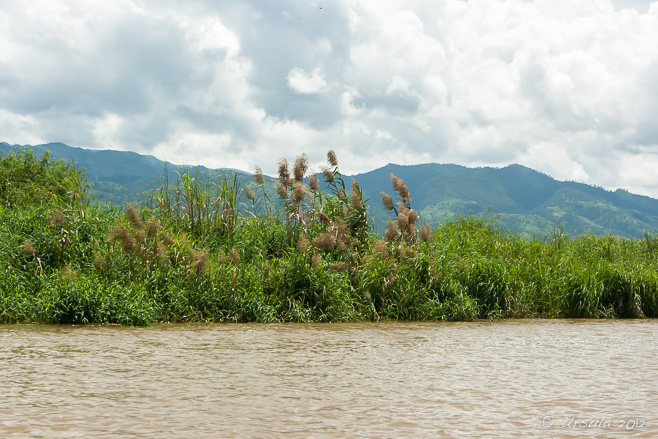
Grass and Mountains The Shan Hills surround us. If it wasn’t for the unremitting noise of our motor, it would be beautifully peaceful on the lake.
Boat Operator We race across the open waters…
Inle Lake Fisherman … while a fisherman stands quietly on his anchored boat with his woven fish-basket behind him.
Spirit House The Intha people are predominantly Buddhist, but some of the old Animist practices live on.
Giant Golden Chicken Burmese barges often have giant golden chickens at the prow; I have no idea why.
House on Stilts Raised up on poles, this house – unlike many others we saw – has a lovely large porch.
Jasmine Inle Retaurant Our lunch stop is at a multi-story restaurant on the water…
View over the Lake … where we had a wonderful meal in the airy rooms upstairs, …
Houses and Temple … with views over the lake and the Shan Hills.
Restaurant Staff Two women from the restaurant help push our boat back off after lunch.
Temple on Inle Lake
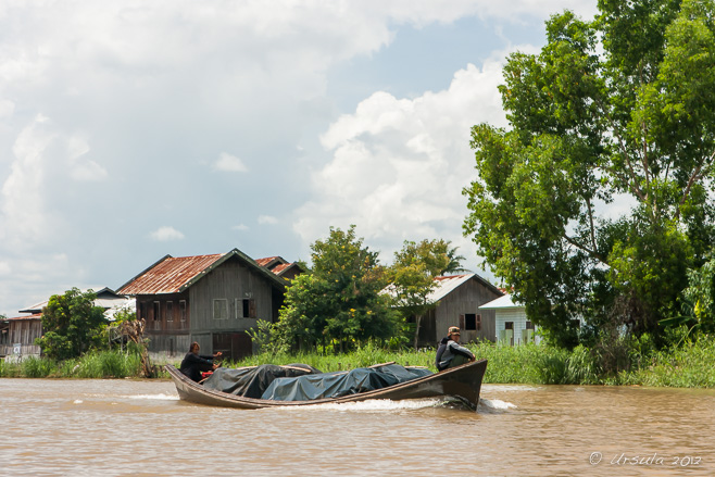
Boat on Inle Lake The muddy waters are busy with heavily laden boats.
Farmer on the Lake The poles allow the planted vegetables to climb – and also prevent the whole patch floating away.
Young Man on the Lake Even the young take their turns checking the plants.
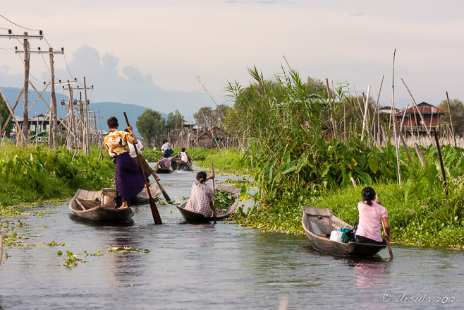
Women on the Lake The water corridors extend through the vegetation.
Woman Paddling
Tending the Crops
Grocery Store The stilted buildings crowd the narrow waterways …
Bringing Home the Groceries … which are full of boats laden with people and baskets of goods.
Water Hyacinth ~ Eichhornia Crassipes Although pretty, water hyacinth is a non-native pest which grows fast, clogging the smaller streams and depriving local plants and animals of light and food.
Little Girl at the Window As our boats chug between the rows of houses, locals watch from the windows of their modest homes.
Woman at the Window
Old Woman at the Window
Man and Baby
Old Man Some of the faces are as weathered as the wooden walls…
Fixing the Pole What the neighbourhood lacks in amenities, it makes up for in community. A group of men works on getting new poles installed.
Afternoon Light The afternoon light angles across the water, into our eyes, …
Old Man … casting a warm glow on elderly faces.
Women on the Water People call out to their neighbours as they row through the “streets”.
Young Rower The lads start leg rowing at a young age – although I think this one is still having to concentrate.
On the Stoop I can’t imagine how one safely contains active toddlers in houses that open directly onto the water!
Kite Flyer Flying kites is one of the few activities available to kids without electronic gizmos – or local parks or playing fields.
A Last Look over the Water
Purple Evening We head “home” when the light drops to the point where we can barely see… but the boats don’t stop.
One of my Facebook contacts is participating in a “30 days of gratitude” project, posting what she is grateful for daily. It has made my Newsfeed a much nicer place.
The world as a whole would be a nicer place if we all took notice of how lucky we are, instead of feeling entitled to all the “things” that we have – and more. After all, so many of the opportunities that come to us along the way are the byproduct of where and when we were born.
Every time I travel, I am grateful for the opportunity to visit new places. In many of these places, people have very few of the material advantages most of us take for granted. It reminds me just how different one’s day-to-day life can be, and I am always appreciative of the locals who are willing to share a little of their world with me.
[…] written before about it’s floating villages (Life on the Water) and about it’s distinctive leg-rowing fishermen (Iconic Images). Most of the […]ReplyCancel
[…] square-mile (117 square-kilometer) lake is known for its leg-rowing Intha fishermen and its floating villages. Amongst the reeds and narrow waterways, the ethnic markets and buddhist pagodas are also worth a […]ReplyCancel
[…] was in Nyaung Shwe on the north shore of Inle Lake in Myanmar, with photographer Karl Grobl, local guide Mr MM, and nine other photography […]ReplyCancel
Roof of the Heavenly King Hall Nan Putuo Temple, Xiamen, Fujian Province, China
新年快樂 ~ Gōng xǐ fā cái ~ Happy New Year.
It is Chinese New Year today – a perfect time to visit a Chinese Temple.
Last spring I got to explore Xiamen in Fujian Province, Southeast China, while my husband was busy with meetings. I spent a few delightful days wandering around the coastal city – mostly on foot – with a crumpled map in hand.
One of the highlights on the tourist map is the sprawling Nan Putuo Buddhist TempleComplex. Built at the foot of the Wulao Peaks, it is named for Mount Putuo near Shanghai, one of the four sacred mountains in Chinese Buddhism, and a pilgrimage site for over a thousand years.
During the Tang Dynasty (618 – 907), the Buddhist monks who lived in the hills here had the area established as sacred Buddhist land and built the first temple dedicated to the Bodhisattva Guanyin. Today, the extensively renovated complex spreads over 25.8 hectares, and houses (among other buildings) the Buddhist Institute of South Fujian.
It is easy to enjoy a few hours – or a whole day – of quiet, wandering through the buildings and shrines, or exploring the surrounding woods.
Gardens The temple sits amid green, sculpted gardens and and ponds.
“Free Life Pond” At the front of the complex, there is a pool for freeing and feeding pond animals. Turtles and carp are popular choices.
Monks in the Courtyard The temple is a popular pilgrimage and study site, with about 120 monks residing permanently.
Candles
Lighting Incense
Smoke
Heavenly King Hall People kneel and pay their respects before entering the hall.
Reflections of Nan Putuo Temple A golden guardian protects the temple entrance. In the reflection, you can see temple buildings, one of the layered white Longevity Towers, and Wulaofeng: theFive Old Men Mountain.
Scaffolding New buildings are being added; the new work is as ornately carved and decorated as that on the older buildings.
Buddhas in a Cage Even though the golden Buddha and Bodhisattva images are out of reach…
Lotus … the faithful still bring offerings of flowers and drinks.
Ornate Grill Delicate work adorns the stone balusters.
Temple Grounds Stairs go off in all directions …
Temple Grounds … so that you can feel alone with the rocks and trees, …
Man on a Rock … and you can find quiet places to sit.
Stupas in the Garden
Icons in a Cave One of the small caves on the hillside is filled with hundreds of small Buddhist statues.
Teahouse Entrance By the time you have climbed up to the teahouse, you have earned a break!
Prayers As the rough tracks and stairways lead off into the woods, the way is brightened with random prayer flags and bougainvillea.
Delicate Flowers Small wildflowers grow in the leaf litter.
Shoes on the Stairs When I see the footwear the local women sport to clamber up and down all the stairs, I am ashamed to feel tired and sore.
View As you get higher up, there are great views over Xiamen.
Old Monk on the Stairs
Old Monk
Shrine Around every corner, there are shrines…
Stupa … and memorials …
Oil Lamp … and lamps to be lit.
Buddhist Complex Back at city-level, there are more buildings next to the monks’ quarters.
Master Hongyi (1880-1942) Before leaving the complex, I stop at another of the memorials – this one for Master Hongyi (Li Shutong), Chinese Buddhist monk, artist and art teacher.
I always find Buddhist temples calming, and when they integrate nature, as this one does, it makes a wonderful break from the hustle of the city.
I wish you quiet breaks in your busy lives, and everything good in the “Year of the Goat”.
[…] contributes to the “liveability” of the city: it has preserved the past in its temples (see: Nan Putuo Temple), forts, and other historical buildings (see: Gulangyu Island); it is surrounded by water and […]ReplyCancel
Rocky Shore The shoreline is as wild at Hot Springs Cove in Maquinna Marine Provincial Park as is it around the rest of Clayoquot Sound, BC.
Once upon a time, if you came upon Hot Springs Cove very quietly, “hippies” could be spotted under the full-moon, frolicking nude, like faeries in the woods. Isolated and wild, the cove shelters geothermal hot springs, where the waters – naturally heated to a glorious 50°C – are pumped out at a rate of over five-litres-per-second.
These hot springs, at Sharp Point on the Openit Peninsula on the rugged west coast of British Columbia’sVancouver Island, have always been isolated. There are some small un-incorporated communities in the area, but the only access is by boat or seaplane. Traditionally Hesquiaht(Nuu-chah-nulth First Nations) territory, most of the peninsula is now part of the Maquinna Marine Provincial Park. The park, which is named for 18th century First Nations Chief Maquinna and his descendants, includes a number of Nuu-chah-nulth First Nations cultural heritage sites.
Isolated though the hot springs may be, they are far from deserted. This popular tourist attraction is only an hour and a half north-west of Tofino by motor boat, or 15 minutes by sea plane, and a number of tour companies offer daily trips: cruising the 26 nautical miles up the rugged coastline through UNESCO listed waters to the Maquinna Provincial Park and the still-popular Hot Spring Cove where people from around the world enjoy the reputedly healing waters.
If you set off early enough (which we didn’t) there is a chance of spotting bears. The area is also home to cougar, mink and wolf – none of which we were likely to spot from our noisy, but comfortable, 30-ft aluminum cabin cruiser. Bald eagles and tufted puffins are regularly spotted and the waters are said to be full of Gray whales, orcas, and humpbacks, as well as the more common Stellar and California sea lions, dolphins and porpoises.
We packed our swimmers, towels, and some rugged water-proof shoes for the rocks, and set off.
Cleaning Fresh Fish Tour boats and fishing boats keep the working dock down from our hotel busy. Tofino is a working town: mining, logging and, of course, fishing. The young man’s tee shirt is a reminder that we are in the Pacific Rim, and therefore in tsunami territory. I remember watching the news about the Great Alaskan Earthquake of 1964, which resulted in 131 deaths up and down this sparsely populated coastline.
Tofino Waters … and into the Clayoquot Sound Biosphere Reserve.
Window on the Waters Even from inside the boat, there is a good view of the magnificent coastline.
Tofino Waters I prefer to be out in the fresh air, leaning over the rails of the boat, watching the waters go past.
Bald Eagle (Haliaeetus Leucocephalus) If you watch carefully, you can spot Bald Eagles in the trees…
Bald Eagle (Haliaeetus Leucocephalus) … or soaring in the air.
Skipper Our skipper and guide keeps up a running commentary on the area, and answers any questions.
Clayoquot Sound Waters Water, trees, mountains… and just a touch of snow in the distance.
Motors Even with a pair of big motors…
Travelling North … it’s about an hour and a half to Government Dock at Hot Springs Cove, …
Nasal Opening – Humpback Whale … especially when we slow down for animal sightings, like this massive humpback whale, hiding in the navy waters.
Bald Eagle (Haliaeetus Leucocephalus) with Fish
Hot Springs Cove We cruise past where the hot springs empty into the ocean. Unlike the old days, swim suits are no longer optional.
Changing Rooms Aside from toilets and some changing cubicles, the actual hot spring area has been left completely undeveloped. It is, however, easily accessible from Government Dock via the well-maintained 1.2 km boardwalk.
Das Boot There are some small communities around the area – locals get in and out by boat.
Government Dock Our boat ties up at Government Dock for a couple of hours…
Into the Woods … so that we can make the 30 minute walk through the Temperate Rainforest (Coastal Western Hemlock) to the hot springs.
Stump The coastal regions of the park are home to Western Hemlock, Western Red Cedar, Amabilis Fir, Western Yellow Cedar, Sitka Spruce, Pine, Douglas Fir, Yew and Red Alder. To me, it’s just “woods”.
Boardwalk The 1.2 km boardwalk from the dock to the hot springs is maintained with the help of planks sponsored by boats who have anchored in the cove.
Rainforest Ferns
Steam Rising Rainwater seeps about 5 kilometres into the faults in the ancient igneous and metamorphic rocks, and is thermally heated to over 109°C before being forced back to the surface, and flowing through the rain forest …
Hot Springs Falls … and cascading down a small cliff into a series of five natural layered rock pools: …
Nature’s Spa … each one slightly cooler than the one above it.
Knotty Trunk Too soon we have to make our way back to the the boat, …
Proposal … pausing to admire an ingenious proposal. (I hope she said “Yes.”)
Coast We head back south, rugged coastline to the east of us, nothing but water to the west between us and Japan.
Whale and Rock We come across a number of humpback whales – who disguise themselves as barnacled rocks in the wild waters.
Rhinoceros Auklet (Cerorhinca Monocerata) All types of sea birds fish in the rich waters.
North American River Otter (Lontra Canadensis) A lazy otter welcomes us back to Tofino waters …
Back in Tofino … where we dock, early evening, in time for dinner.
A walk in the woods, time on the ocean and a soak in a natural spa –
Honouring Spirits and Ancestors The traditional woven roof of a Karo Batak house is topped with buffalo horns, Petseren, North Sumatra.
It’s a different world out there…
In this day and age where travel is relatively quick and easy, and when communication is virtually instantaneous, it is amazing to me how much diversity still exists. Some ethnic groups have managed to resist the influences around them and to preserve their age-old traditions.
Sumatra is just one of the 13,000 incredibly varied islands that make up Indonesia. And North Sumatra is just a small part of that one island.
And yet, North Sumatra is home to around five million Batak people: one of the largest of Indonesia’s over three-hundred distinct ethnolinguistic minority groups. They are thought to be descendants of people who migrated from Taiwan and the Philippines through Borneo and/or Java about 2,500 years ago.
But, the Batak are themselves not one ethnic homogeny. They can be divided into six (or nine – depending whom you believe) separate groups with different (but related) languages and customs.
Driving from Berastagi to Parapet early last year took us through the Karo Regency in Bukit Barisan Mountains; that is, through Karo Batak country.
At the Petrol Pumps Our drive starts with a fill-up in Berastagi, where we have spent the night. I am so used to self-serve that it is a pleasure to sit in the car and watch!
Petseren Village Before long, the “modern” tin rooftops of Petseren come into view. The village is also home to a few traditional Karo houses.
Stylised Designs Karo Batak houses can be distinguished from other Batak styles by their hipped roofs. The colourfully woven roof patterns have magic symbolic meanings.
Village Petseren House Rising up on low stilts, Karo Batak houses are built of wood, bamboo and straw – without the use of nails. Access is by a bamboo ladder, which can be taken in at night.
Inside a Karo Batak House Inside the house was impossibly dark; I cranked up the ISO on the camera and shot on manual focus, hoping for the best.
Young Karo Man I often wonder how long the old ways will last when the younger generation has access to the rest of the world via television and internet.
Fixing Lunch Karo Batak houses are “open-plan”, with no internal walls. Mats and blankets suggest areas and work-spaces. I was never sure where to step, and felt large and clumsy next to the people inside.
Old Woman The longhouses are communal, housing up to eight or twelve families. The “kitchen” area is visible behind grannie.
Kids Playing Back outside in the bright sunlight, children play in the dirt…
Doing the Washing … and a woman does her laundry.
“Modern” Housing The old-style longhouses are no longer being built. The modern replacements are pretty basic.
Karo Batak House Some of the old houses have stood for up to three hundred years.
Plants on the Roof The straw roofing collects moss and even ferns.
Guarding the Grain Animals find cubby-holes under the floors.
Sipisopiso Waterfall Our next stop was at the northern end of Lake Toba – at the site of Indonesia’s highest waterfall. Sipisopiso Falls starts at a small underground river in the Karo Plateau, and tumbles 120 metres into the caldera that forms Lake Toba.
Mists and Fire The area around Sipisopiso is well-tended agricultural land.
Entrance to Rumah Bolon Our next stop is in Simalungan Batak territory, where we visit the Rumah BolonPalace Complex near Pematang Purba. An arched entrance leads into the grounds.
Rumah Bolon Longhouse Now a museum, the complex was home to the Simalungan Batak chiefs until 1947, when the last one died.
Pillars The king’s long house was built of solid teak by Chief Tuan Rahalim (r.1886-1921) and stands on twenty decorated poles. All the designs are in white, for the holy spirit; red, denoting the way of life; and black, symbolising black magic.
Inside the King’s Longhouse The long house was divided into living quarters, a cooking area, and sleeping quarters with apartments for each of the chief’s many wives. Later kings were Christian – rendering room for extra wives unnecessary.
Flowers in the Grounds
Rumah Bolon Outbuilding All of the buildings on the complex are beautifully renovated and maintained.
Buffalo on the Roof As is the case with the Karo Batak, in Simalungan Batak culture buffalo skulls and motifs symbolise the power of the chief.
Southern Pig-tailed Macaque Late afternoon, as we got closer to Parapat, we came across a troop of southern pig-tailed macaques (Macaca nemestrina).
Southern Pig-tailed Macaque Thanks to some fruit I had left over from the morning markets, the monkeys sat and posed – keeping a watchful eye on each other.
Family ~ Lake Toba Once we settled into our accommodation in Parapat, we went for a walk along the edge of Lake Toba, where we met a local family taking a break.
Parapat Mosque Most of the Batak people were converted to Christianity in the 19th Century by Dutch missionaries, but they also maintained their traditional beliefs. Today, surrounded by the Indonesian Muslim majority, more are practicing Islam.
Since their arrival in Sumatra, the Batak people have managed to maintain their language and aspects of their culture in the face of external pressures. Indonesian government policies do not recognise traditional religions, so while Batak still maintain many Animist traditions, their identity cards would show them as being Christian, or – to a lesser extent – Muslim.
Batak people are found among Indonesia’s poets and politicians, singers and sports-people. I guess the trick is to find a way to maintain one’s own culture while still being part of – and helping to inform – the larger society around oneself.
[…] the centre of Batak culture. Descendants of a powerful Proto-Malayan people, the Batak comprise “six (or nine – depending whom you believe) separate groups with different (but related… The largest of these related groups – and the most culturally distinctive – […]ReplyCancel
[…] people who probably arrived in the region about 2,500 years ago, the Batak comprise “six (or nine – depending on whom you believe) separate groups with different (but related)… The most populous of these groups is the Toba Batak, centred around Lake Toba – the […]ReplyCancel
Sunburst on the Chhatri Afternoon at Vyas Chhatri, Jaisalmer.
They say you are a long time dead and buried –
Well, unless you are buried in Switzerland, where your plot is reclaimed after 25 years to recycle available land. Or, unless you are in a traditional Chinese cemetery, where your bones should be taken out and washed annually…
In India, honouring the dead can take many varied forms. Although most Hindus are cremated, as I and my companions learned on the Ghats at Varanasi, sadhus do not need burning, for they are deemed to be already pure. They, therefore, are wrapped in a cloth or rug and tipped into the Mother Ganges. Their bodies can be seen, floating in the murky waters.
At the other extreme, the Mughal emperors built elaborate mausoleums so that they, and their families, would be remembered forever. Perhaps the most magnificent of these, the Taj Mahal, stands as a testament to love and to architecture.
The arid, desert landscape around Jaisalmer is punctuated by pagodas, built from the local golden sandstone, on the cremation sites of the wealthy and powerful. Each of the region’s traditional Bhatti (Yaduvanshi) Rajput rulers built a cenotaph to commemorate their reign.
If you read the revues on TripAdvisor etc., what distinguishes these sites today is their dereliction. Although they are advertised to – and frequently visited by – tourists, (especially as places to enjoy desert sunsets) they are neglected and uncared for.
It was, in part, this very dilapidation that added to the eerie atmosphere of quiet that surrounded the Vyas Chhatri cenotaphs close to Jaisalmer when I visited late one November afternoon.
Into the Cenotaphs Strewn with rubbish and firewood, and falling into disrepair, the cenotaphs are a symbolic “mark of respect” to those who were cremated here.
Sleeping Dog A stray dog sleeps – oblivious to the pending onslaught of afternoon tourists.
Cenotaph You can see residential buildings – and other cenotaphs – not so far away.
Pavilion Chhatrisare dome-shaped pavilions commonly used in Rajput architecture to depict pride and honour.
Playing the Algoza The haunting sounds of the Indian double flutes wafting on the afternoon air adds to the atmosphere.
Domes Afternoon light on the domes of the chhatri highlights the delicate carving.
Square Pavilions Just visible in the background is the metal cover over the burning platform which is still in use for Brahmin cremations.
Chhatris and Sky
Playing the Algoza A traditional musician plays for the tourists, hoping to sell CDs.
To the Vantage Point Tourists walk uphill with cameras and tripods to catch a desert sunset.
Playing the Algoza Meanwhile, in another nook, another man plays music, …
Hands on the Algoza … deftly fingering both flutes.
Tourist and Camera Tourists are everywhere – trying to catch the fast-falling light.
November Sun The autumn sun drops quickly in the sky…
Vyas Chhatri Sunset … until the landscape almost disappears.
Pagoda Sunset Last light in the Vyas Chhatri pagodas.
Dusty, dirty, strewn with rubbish and falling into disrepair, true.
But also, atmospheric, mysterious, and alive with history…
- Performing the Ganga Aarti from Dasaswamedh Ghat, Varanasi
- Buddha Head from Shwedagon Pagoda, Myanmar
- Harry Clarke Window from Dingle, Ireland
- Novice Monk Shwe Yan Pyay Monastery, Myanmar
Packets of 10 for $AU50.
Or - pick any photo from my Flickr or Wanders blog photos.


 Until next time~


 A walk in the woods, time on the ocean and a soak in a natural spa –


")

Ursula, I truly enjoyed this posting. Beyond the wonderful photography, you gave us a glimpse into these peoples lives and culture.
Thanks so much, Barry!
A bit different from your last lush Yellowstone NP set, isn’t it?
All the best, Ursula
[…] written before about it’s floating villages (Life on the Water) and about it’s distinctive leg-rowing fishermen (Iconic Images). Most of the […]
[…] square-mile (117 square-kilometer) lake is known for its leg-rowing Intha fishermen and its floating villages. Amongst the reeds and narrow waterways, the ethnic markets and buddhist pagodas are also worth a […]
[…] was in Nyaung Shwe on the north shore of Inle Lake in Myanmar, with photographer Karl Grobl, local guide Mr MM, and nine other photography […]