 Makam Raja Sidabutar
The garden with the sarcophagi of the Kings of Sidabutar, reputedly the first people to set foot on Samosir Island in Lake Toba, North Sumatra, is an important cultural heritage site on that island. The breadth of human culture is amazing to me: as much as there are similarities in the human condition the world over, there are also such differences in how people express themselves.
Sumatra is just one of the over-17,000 islands that make up the Indonesian archipelago; just one of the 922 permanently-populated islands. With its numerous ethnic groups speaking 52 distinct languages, this island alone represents a huge range of cultural diversity.
In North Sumatra, one of Sumatra’s ten provinces, most of the 13½ million inhabitants are Batak. Descendants of an Austronesian people who probably arrived in the region about 2,500 years ago, the Batak comprise “six (or nine – depending on whom you believe) separate groups with different (but related) languages and customs.” The most populous of these groups is the Toba Batak, centred around Lake Toba – the natural water-filled caldera of an ancient super-volcano – and on Samosir Island, the large volcanic island within the lake.
The fifth largest lake-island in the world, Samosir is a popular tourist destination, providing a glimpse into the rich cultural heritage and current lifestyle of the Toba Batak people. One traditional Toba Batak village is maintained as a museum (Huta Bolon Simanindo) and other special sites dot the island.
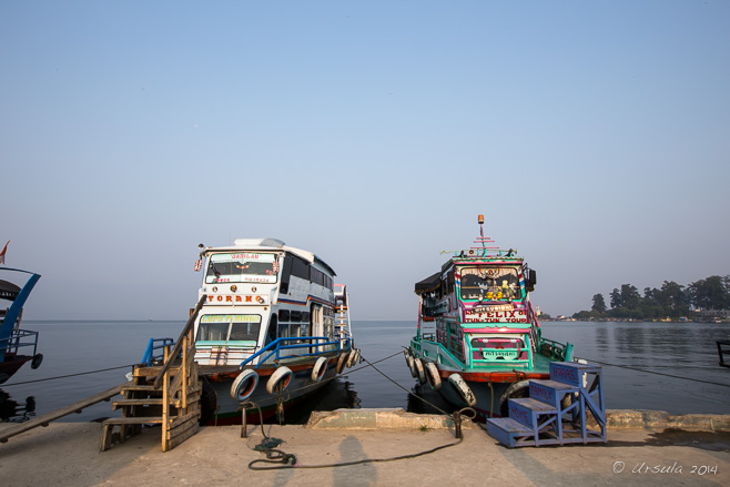 Ferry Boats on the Quay
The small town of Tuktuk on Samosir Island is an hour-long ferry trip across the lake from Parapat where we (like most tourists) were staying. 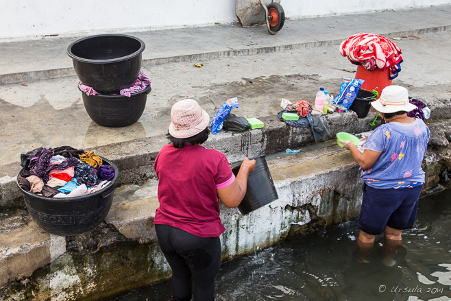 Women doing Laundry
As well as being a meeting point for the hourly ferries, Tiga Raja Harbour served as a good place to do the household laundry.  Into Tuktuk, Samosir Island
The curved roof of a traditional Toba Batak house, or “rumah bolon”, comes into view as we approach the island shore. Rubbish
One of the big problems in relatively remote places like Samosir Island – especially those with high tourist numbers – is dealing with waste. Tiny Buffalo; Huge Sea God
Although the majority of Toba Batak are now Christian, representations of their traditional beliefs are built into their houses and depicted in statues and shrines all around the island. Mexican Sunflowers (Tithonia diversifolia)
The roads are bounded by wild flowering bushes as we climb into the hills of Samosir. Roadside Grave
Elaborate memorials to beloved ancestors are never far away; … Rice Field Mausoleum
… whether in a field or at the roadside, mausoleums of all ages and styles are everywhere. Red White and Black Mausoleum
One particularly large mausoleum we passed was easily two stories high, and elaborately decorated in traditional Batak designs in the symbolic colours of white (the holy spirit), red (life force), and black (magic). Makam (Tomb of) Ompu Raja Rosuhul Sihaloho
This site contains the remains of King Rosuhul (“Earthquake” – named so for his fabled ability to tame quakes) and about thirty of his descendants. Grave of Ompu Raja Rosuhul Sihaloho
The stone sarcophagus is approximately 215 years old. It is less well-cared-for than another we visited (later) because the clan became poor, and no longer had the right connections. Rumah Bolon in Disrepair
The traditional rectangular wooden homes, which housed up to five or six families, were beautifully made in their time, but many are very old and falling into ruins. Toba Batak Houses
In some villages, traditional Rumah Bolon alternate with “modern” box houses with cladding and corrugated iron roofs. Buffalo on the Roof
The traditional designs and symbols – like the buffalo which represents the power of the Chief – are beautifully maintained on some of the buildings. Young Toba Batak Woman
Still, there is a desolate air around most of the villages. Tugu – “Monument”
Whether they are tributes to ancestors and kings, or memorials of battles, monuments are everywhere. Shop Keeper
I am always ready to examine (and often buy) locally woven fabrics in intricate designs. Ambarita Village Home
Probably because of its proximity to a site of local importance, Ambarita Village felt more “alive” than many we passed. King Siallagan’s Stone Chairs
Huta Siallagan or the “Stone Chair Village” in Ambarita was built by Si Raja Laga Sialagan several hundred years ago. The chairs were where the village elders sat to discuss crimes, decide guilt, and mete out punishment. Huta Siallagan – Killing Stone
The ultimate punishment, decided in accordance with Pelebegu, a local Animist tradition, was by beating with a blunt object, then a ceremonial beheading, and finally the body was carved up for cannibalising. Punishments could only be decided on auspicious days according to the old Batak calendar. The View from the Highlands
The view today is miles away… The View from the Highlands
… from the ritual cannibalism of years past. Market
To get to the most important attraction on the island, you need to ford the market of souvenirs and clothing. “Another Guide Another Burial Site”
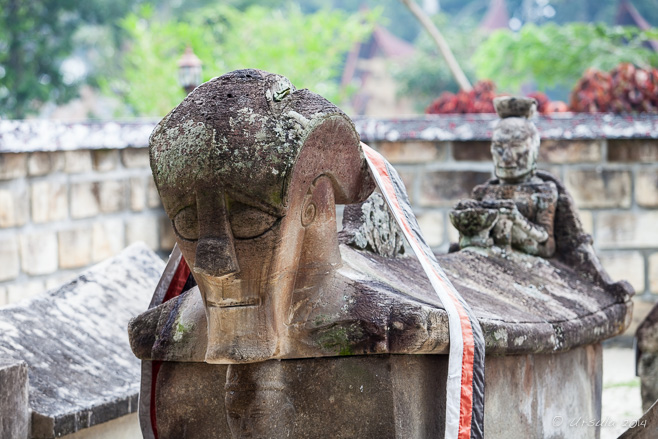
Visitors to the Makam Raja Sidabutar (King Sidabutar’s Tomb) are asked to wear a special sash as a mark of respect for the Sidabutar family, the ancient ruling clan around the Batak village of Tomok. Makam Raja Sidabutar
According to stories, one of the Sidabutar lineage: King Ompu Ni Ujung Barita was an elderly man when he finally arranged to marry a woman named Anting Malela Boru Sinaga. She broke the engagement by refusing to carry a ritual cup without handles on her head. King Ompu Ni Ujung Barita used black magic to make her crazy as punishment. His sarcophagus depicts him on the front and Anting Malela at the back, carrying a cup without handles on her head as a sign of the ultimate obedience. Local Man at Makam Raja Sidabutar Carving at Makam Raja Sidabutar
The Sidabutar tomb site is well-maintained, and dotted with sarcophagi and small ritual carvings. Hawker on the Ferry Dock
At the end of a long busy day, we are back on the ferry. Boys on the Shore
Local boys race up to the ferry dock, disrobe down to their underpants… Portrait of a Batak Swimmer
… swim out to the ferry, hang onto the mooring lines, … Waiting
… and watch for the ferry passengers to throw money into the water. Diving
The boys all dive after the folded notes, … The Race is On!
… keeping us entertained until the ferry leaves… Ferry on Lake Toba
… to take us back to Parapat. From cannibal kings and black magic to tourism and young lads staying fit chasing money in the lake waters…

Times have changed and will continue to change.
I hope the Toba Batak can manage the change well.
‘Till next time!
Pictures taken: 19February2014
Posted in Indonesia,pre-history,Religious Practice,TravelTags: Batak,culture,history,Indonesia,North Sumatra,Photo Blog,sumatra,travel,Travel Blog,Ursula Wall
Man with a Cheroot
A man takes a break, squatting on the bundles of bamboo that sit at the docks of the Thaung Tho Market on Inle Lake. Inle Lake, Myanmar’s second largest freshwater body of water, sits in the mountainous-west of the multi-ethnic Shan State. The 45 square-mile (117 square-kilometer) lake is known for its leg-rowing Intha fishermen and its floating villages. Amongst the reeds and narrow waterways, the ethnic markets and buddhist pagodas are also worth a visit.
The markets around Inle Lake are held on a rotating five-day cycle. The one at Thaung Tho Kyaung, a Pa’O (Taungthu) village in the canals well south of the city of Nampan, is a popular event which brings the local people down from the surrounding hills and in from the waterways.
The Pa’O people are the second largest ethnic group in the Shan State – and many live on and around the lake.
Life on the Water
Whatever you want to do on Inle Lake, you do it by boat. Our Boat on the Lake
Our boatman steers us through the waterways… Portrait of a Boatman
… to our various destinations around Inle Lake. Thaung Tho Kyaung Pagoda
We pass many beautiful Buddhist temples on our travels. Boats at the Dock
Our docking point near the Thaung Tho Market is already busy with boat traffic. Man on a Break
Bamboo is big business. These long, strong, pieces are used extensively for construction. Woman at the Dock
Smaller pieces of bamboo and other non-wood fibres are woven for walls, floors and roofing. Washing Dishes
The Thaung Tho Market is a busy place: they are already washing up at the coffee hut. Paan Maker
Dotted all around the markets are stalls for preparing paan: betel quid. Called kun-ya (ကွမ်းယာ) in Burmese, the quid is a combination of areca nuts with spice and/or tobacco wrapped up in betel leaves. Making Betel Paan
The word “paan” comes from the Sanskrit word “parṇa” (leaf). The betel leaf is spread with slaked lime – a calcium hydroxide paste – which helps release the alkaloid stimulants in the betel leaf and areca nut. Betel Leaves and Areca Nuts
Limed betel leaf is filled with chopped areca nut… Tobacco Tins
… and a mixture of tobacco and spices… Making Betel Paan
… before being rolled into a packet … Chewing Paan
… and tucked into one’s mouth to be chewed. Young Man in Thanaka Powder
Although young, this betel-paan salesman already shows some signs of the oral problems caused by chewing quid. Thaung Tho Market
The markets are a centre for the local Pa-O (Black Karen) people and include produce, clothing and trinkets. Pa’O Women
Although many Pa’O women now wear modern blouses or sweaters instead of the traditional black jackets, they still wear their woven checkered head-dresses. These vegetable-sellers wait for customers, … Pa’O Women
… as they survey the market area. Young Monks
These three boys were enjoying “window shopping” together. It is not uncommon for young boys to become Buddhist novices. Pipes
Ornate pipes are amongst the bits and baubles on offer. Checking out the Goods
A Karen man examines a length of fabric… Transaction
… and makes his purchase… Karen Man
… without ever loosening his grip on his cheroot. Karen Woman and Child
With her baby in a carry-sling, a young Karen mum does her shopping. Boats on the Dock
As we leave the markets, the dock area is busy with people loading the 20-foot lengths of bamboo. I love markets for the glimpse they give into people’s every-day lives.
Two things stood out for me at this one:
Firstly, time is paced differently: there is a lot of standing or squatting while watching and waiting – interspersed with bursts of activity or labour-intensive periods. Whether you are waiting to sell your bamboo or your vegetables, or waiting for your betel paan, you will have long spells of inactivity.
Secondly, stimulants – in the form of coffee, cheroots and betel paan – have a more prominent role than any single food-stuff.

I guess the stimulants help with those long periods of idleness…
Until next time ~
Photos: 21-22September2012
Posted in Every Day Life,Myanmar,Travel,WorkTags: blog,boats,environmental portrait,environmental portraits,market,Myanmar,people,Photo Blog,portrait,travel,Travel Blog,Ursula Wall
Rutledge Falls
Part of the Short Springs Tennessee Natural Area, Rutledge Falls is a stunningly beautiful waterfall on Crumpon Creek. It is late spring in Middle Tennessee and the dogwood and magnolia trees are in full bloom. The grass is green and the honeysuckle is hanging from the woods in fragrant bunches.
I am always amazed by how much wild, wooded space there is in Tennessee. From the iconic mountains in the Appalachian chain in the east, to the fertile valleys between the Tennessee and the Mississippi Rivers in the west, the rural countryside alternates with lakes, woods, and waterways. In the towns and suburbs, big houses sit well back from the roadways, fronted by expansive, manicured green lawns and surrounded by stately trees.
In Middle Tennessee where the endless multi-lane highways are bounded on all sides by dense forests of deciduous trees, the lush rural landscape – dominated by rolling hills and fertile stream valleys – is punctuated by picturesque weathered barns of all ages, tidy homesteads, and magnificent horses. And, of course, countless trees.
My husband and I were in Tennessee for family functions – but there is always time for some canoeing on the rivers and walking in the woods.
Do join us!
Dogwood
It is late spring in Middle Tennessee and the dogwood and magnolia trees are in full bloom (iPhone6). Rutledge Falls
Imagine having this in your back yard! Rutledge Falls, Tullahoma, is on private land, but access is open to the public from dawn to dusk. “The Lady of the Falls”
This statue comes as a delightful surprise as you work your way through the woods to the top of the falls. One of three life-sized figures cast by Wood & Perot’s Ornamental Iron Works of Philadelphia, PA, this one, originally called “Night”, was moved to this location around 1958. (For a winter view and more history, visit Lynn Roebuck’s photo.) Rutledge Falls
It is a short, steep, slippery walk down to the water’s edge, … Downstream
… but it’s well worth it for the view. Locals often come to picnic, fish, or swim in the icy waters. Bug: Rutledge Falls Women Chatting
The falls are a popular natural area for tourists and locals alike. Violets in the Leaf Litter: Rutledge Falls Mossy Rocks: Rutledge Falls
The water comes down in small falls around the edges of the creek, … Rutledge Falls
… and in a beautiful veil through the middle. Maple Leaves
A short drive away, still in the Short Springs State Natural Area, there is car parking at the head of a network of trails which includes the short walk to Machine Falls. Mountain Laurel (Kalmia Latifolia)
The air in the woods is hot and still, but fragrant from the spring flowers and foliage. Barrier
The woods are part of a Tennessee State Park, so the steps and trails are regularly maintained – GeoMarker: TVA
– but time and erosion has left some of the Tennessee Valley Authority geo-markers raised up in the middle of the path. Velvet Woods
The woods are dark at the bottom of the hill where the trail meets the bridge over Bobo Creek. Machine Falls
The waters of Bobo Creek drop more than 18 metres (60 feet) over the almost-60-foot-wide Machine Falls – one of the prettiest waterfalls I’ve visited in a long while. In the Falls
Access to the falls is through the cold creek waters; trees and slippery rocks line the sides of the creek, making a dry-footed access impossible. Woods with Character
The spring woods are a lush mix of sycamore, buckeye, magnolia, beech, and tulip trees. The tree barks, and the shrubs and flowers at ground-level, make good excuses to stop on the steep climb back up the hill. The beauty of nature is hard to beat, and I always feel refreshed after time around woods and waters.
I’m looking forward to our next visit.
Till then ~
Happy Paddling!
Pictures: 14May2015
Posted in America,Landscapes,Nature,TravelTags: blog,landscape,nature,Photo Blog,Tennessee,travel,Travel Blog,Ursula Wall,USA,walk,woods
Pikes Peak
Pikes Peak, the highest summit of Colorado’s southern Front Range of the Rocky Mountains, is a stunning backdrop for the rock formations in the “Garden of the Gods”, as seen from the Garden of the Gods Club & Resort, Colorado Springs. It’s impossible not to look to the sky in Central-Eastern Colorado: mountains, cliffs, and ancient stone monoliths launch up into a limitless expanse of blue – broken only by the vapour trails of airforce training jets thundering through.
It seems apt that the area is home to the “Garden of the Gods”: magnificent natural rock formations, set against the backdrop of the Front Range of the Rocky Mountains and under that ridiculously blue sky.
Fine sand from primordial beaches, coarse sand, gravel, silica, and hematite, compressed by the ages into ancient sedimentary beds of red, pink, grey and white sandstones, conglomerates, and limestone, were lifted up and tilted during the same geological upheaval – millions of years ago – that raised the Rocky Mountains and Pikes Peak. Subsequent ages of erosion and glaciation worked their magic, carving out the amazing formations we see today.
Named “Garden of the Gods” in 1859 by Rufus Cable, a young surveyor, the lands were gifted to the City of Colorado Springs upon the death of their owner Charles Elliott Perkins in 1909. Today, the park is open to the public daily, free of charge.
We were staying nearby, and managed a couple of visits to the extraordinary Gardens – as well as to the simulated Anasazi Cliff Dwellings at Manitou Springs, and Colorado Springs’ United States Air Force Academy.
Impossible Colours
Blue-green semi-desert shrublands, dramatic grey and red Lyons sandstone rock formations, a snow-capped Pikes Peak, and a cloudless blue Colorado sky… Garden of the Gods Club and Resort
… combine to make for an arresting view. Kissing Camels and White Rock – Garden of the Gods
The colours of the white and red Lyons sandstone formations are even more dramatic close up. Garden of the Gods
The jagged red rocks rise up out of the landscape. North Gateway Rock
Hiking trails – including those accessible to wheelchairs – wind around the 1,364 acres of public parklands. Scotsman
The rocks in the Garden of the Gods have imaginative names – some dating back to the Pikes Peak Gold Rush of 1858. Balanced Rock and Steamboat Rock
Garden Drive is one of the paved roads winding through the Gardens… Balanced Rock
… giving close access to several distinctive rock features. Kindergarten Rock
The longest continuous expanses of exposed rock in Garden of the Gods is the pink-grey sandstone of Kindergarten Rock. North Gateway Rock
Gateway Trail leads past the limestone monoliths into the gardens. Climbers
Almost invisible against the rock face, climbers make their way up to the peak. On the Rock Face
Climbers need to be licensed, ascend with a buddy, stay on established routes, and use proper equipment. Sentinel Rock
Visitors sit and chat along the Central Gardens Trail. Central Gardens Trail
Sharp spires are all around the shadowed central gardens. Garden of the Gods Awe Inspiring Kissing Camels
The Kissing Camels are a prominent feature on top of the North Gateway Rock formation. Woman at the Springs
The Cheyenne, Mountain Ute and Arapaho people who settled in the region at the base of Pike’s Peak considered Manitou Springs sacred. They thought that the bubbles in the effervescent artesian springs all around the area were from the breath of the Great Spirit “Manitou.” The Manitou Cliff Dwellings
The Ancient Ones (Anasazi) left cliff dwellings – like these reconstructed ones – abandoned all across Utah, Colorado, Arizona and New Mexico. Our visit to this small museum prompted our later visit to Bandelier National Monument further south in New Mexico. T-38 Talon Thunderbird
A jet trainer sits outside the United States Air Force Academy with the ubiquitous Pikes Peak in the background. The United States Air Force Academy Cadet Chapel
The unique architecture of the Cadet Chapel is the first thing visitors to the Academy see. Fly Boy and Girl in the Terrazzo
Cadet dormitories stretch around the Terrazzo at the Air Force Academy… Cadets and an F-15 Eagle
Static aircraft sit in the Academy quadrangle. Inside ~ Looking Out
The Chapel overlooks the greens and the dormitories. Inside the Chapel
It is cool and dark inside the chapel, where the windows vault into the sky. Cadet Chapel
The glass in the lower level of the multi-faith chapel is stained in warm colours. 
That fresh air, wide open sky, and magnificent scenery – natural and man-made – certainly inspires one to look up and give thanks.
Happy Travels!
Pictures: 16-17May2013
Posted in America,Landscapes,Nature,USATags: architecture,blog,landscape,nature,Photo Blog,travel,Travel Blog,Ursula Wall,USA
Bicycle Sunset
Parked along the road that leads to Jaswant Thada (near the Mehrangarh Fort), a bicycle sits silhouetted against the late afternoon Jodhphur sun. Chaos and colour.
For me, those words sum up India.
The chaos is ubiquitous – as a pedestrian, you need to be aware of all parts of your body as you walk across broken pavements punctuated by piles of rubbish and cow pats, through crowds of burdened porters and grasping beggars, and past whizzing bikes and tuk-tuks and potentially dangerous bulls …
But, as any visitor to these pages knows, I love it. On my first visit to Rajasthan many years ago, I was struck by the colours and how they seem to vibrate through the hot, dusty air, and I continue to be captured by it.
Of course, it is not always hot: nothing quite compares to the penetrating cold-damp of a Delhi winter fog. And, it is not always the bright sunlight of mid-day: if you are on a photo-tour, you are bound to be up before the first light and still out as the sun sets at the end of day – as I was one long November day in Jodhpur.
But, whatever time of day or season, the colours – and the faces of the people – are still arresting.
Enjoy!
Long Shadows
If you are travelling on a Photo Tour, you can expect to be up and out before dawn, and still up long after sunset… In a pre-dawn street of Old Jodhpur, the shadows of our group, with photographer Karl Grobl and local guide DV, are projected against a painted wall by the lights of our bus. Woman on the Stoop
There is life in the streets long before the sun approaches the horizon: people are setting up their shop-fronts and chai stalls… Shrine
… or tending one of the many wildly-coloured Hindu shines dotting the streets. Street Lights down a Corridor
Laneways full of detritus are shadowed in the low light. Corridor
Blue-washed houses with green painted doors are a common sight in Old Jodhpur. Portrait of a Woman in Red
People in the streets are always ready to stop, smile and have their pictures made. Dog in Blue Watchful Blurring the “Pepsi”
As morning breaks, people start on their day’s business… Girl on the Move
… hurrying past on foot … Wheels
… or on scooters. Dog on a Stoop Woman at the Tap Man on a Balcony The Morning Paper Black and Yellow Tuk-Tuks
Drivers sit in their three-wheelers, waiting for business. Beware the Bull!
This brahman bull is known for his bad temper: he’s no risk to the passing scooters, but those of us on foot need to keep a wide berth. The Blue Door Passing the Blue Door Veggie Seller and her Wares
Morning street markets are just that: goods in baskets, on the street. The produce all looks very fresh. Veggie Seller Veggie Seller
Old scales with lead weights are a part of the transactions. Tuk-Tuk Chaos
You get a real sense of the street chaos from inside a tuk-tuk on a busy road. Jaswant Thada
After a visit to the nearby Mehrangarh Fort, we made a late afternoon stop to Jaswant Thada, the white marble mausoleum built in 1899 for Maharaja Jaswant Singh II. Musician on a Traditional Stringed Instrument
Hoping for donations, performers in brightly coloured turbans entertain visitors to the Jaswant Thada memorial site. Musician on a Harmonium
A simple Indian harmonium can be boxed up and carried away. Musician: Jaswant Thada Rao Jodha Ji Statue
As we leave the Jaswant Thada monument, the afternoon sun drops behind the statue of Rao Jodha Ji, founder of Jodhpur, on his magnificent Rajasthani horse.  Wonderful, chaotic, clashing colours – any time of day. Wonderful, chaotic, clashing colours – any time of day.
Namaste!
Photos: 06November2013
Posted in Every Day Life,India,Portraits,TravelTags: architecture,blog,environmental portrait,environmental portraits,hindu,India,people,Photo Blog,portrait,travel,Travel Blog,Ursula Wall
« Older posts
Newer posts »
|


")
