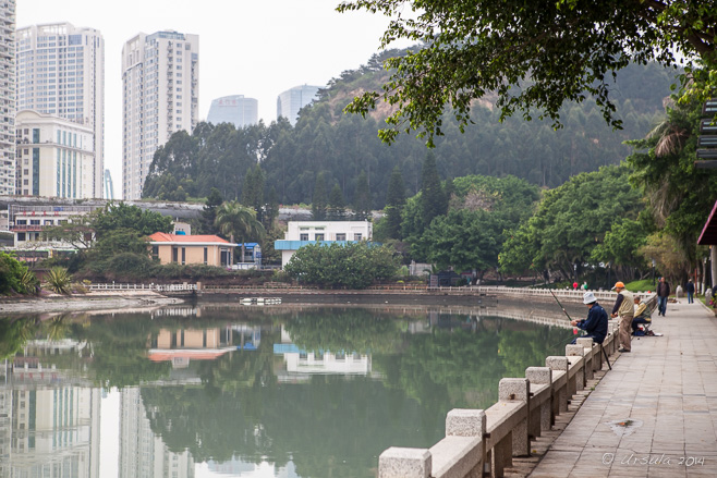
Fishing on Yundang Waihu Just another day in Xiamen, China: men quietly fishing in timeless tradition on Yudang Lake, as the modern city rises up behind them.
It is reasonably accessible to foreign tourists, as well. Some time ago, while my husband was busy with meetings in a nearby free-trade zone, I spent a few days following a dual-language map around the city.
First established during the Ming Dynasty (A.D. 1368-1644) as a major Chinese seaport, Xiamen – with its industrial-development, investment, and free-trade zones – continues to be an important land, sea, and air hub for Southeast Asia. Only 180 kilometres (110 mi) across the Taiwan Strait(Formosa Strait) from Taiwan, it considers itself an international city.
Rather ethnocentrically, I took “international” to mean Westernised, but although Gulangyu Island, a short ferry ride from downtown Xiamen, features Victorian-era European architecture, Xiamen itself is very Asian. Many of the Hokkien natives of this area emigrated to other countries in Southeast Asia during the 19th and early 20th century; many have returned with “foreign” (Asian) ideas, and some with money for universities and cultural institutions.
It is probably this free-flow of money and ideas that contributes to the “liveability” of the city: it has preserved the past in its temples (see: Nan Putuo Temple), forts, and other historical buildings (see: Gulangyu Island); it is surrounded by water and filled with parks, lakes, cultural buildings, and public art; and its university, the first university in China founded by overseas Chinese, helps the city look to its future.
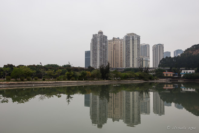
Xiamen High-Rises Yundang Waihu– Yundang Lake is a tranquil oasis in the city –
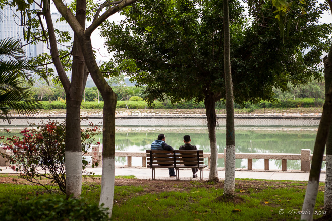
Around Yundang Waihu – where locals walk, or fish or just sit.
Bailouzhou Park Entrance In the middle of Yundang Lake is a large island park with four access points. Elaborate stone sculptured gates decorate one entrance.
Stone Sculpture Other sculptures can be found within the large park – which also houses various recreation facilities.
“Keep the Environment Clean and Preserve Social Morality” This isChina: there are signs everywhere, telling us what to do!
Cotton Tree (Bombax Ceiba) The park is a natural buffer against the city – for the local people, …
Cotton Tree (Bombax Ceiba) … for lovers of beauty and nature, …
Lake Waterfront … and for resident and migratory birdlife.
Steps down to the Harbour Waters The Port of Xiamen is an important and busy deep-water port –
Swimmers in the Port – but even so, swimmers, with their own life buoys, do their morning exercise in the chilly harbour waters.
Working Boats The harbour is full of ferries –
Loaded Ferry – laden with goods and/or passengers.
Woman on the Harbour On a harbour walkway there is a sculpture of a woman waiting for the boats to come in.
Gulangyu Island Across the sea mists, Gulangyu (Kulangsu) Island, a popular domestic tourist destination, is also accessible by ferry service.
Fruit Sellers On the street, fresh-fruit sellers set up their rose-apple stands.
Street Scenes A few blocks away, other fresh fruits are available on the sidewalk.
Two Men and a Fungus? There is a plaque, in Chinese, explaining this art piece. I can’t even guess what they are doing, and could find no information on line – but it is another example of the sculptures dotted around the city.
“Poison to Raise Colour” I think something has been lost in translation; sweet basil seeds are often used in Asian cooking, and are considered a super-food and slimming aide. But “poison?” Perhaps “potion”.
Lucky Turtles Another sculpture has been erected under a tree in a major thoroughfare.
China Town? A Chinese restaurant sits among some other old-style looking shop-fronts.
Stringing Beads There are a variety of things available in the open-air markets on the wide city streets.
Mannequin The shop-fronts make for fascinating window-shopping.
Walmart This I did NOT expect! International, indeed.
University Entrance Xiamen University makes the TripAdvisor list of places to visit. There was a special function on the day I tried, and only those with invitations were allowed in. I spent the afternoon at Nan Putuo Templeinstead.
“A Brief Introduction to Hulishan” Hulishan Fortress was built in the 1890s, during Emperor Guangxu’s reign, on a strong base made of camphor tree sap mixed with liquid brown sugar, glutinous rice, clay and sand.
Cannon Fire When I arrived at the fort, “solders” in period dress were reenacting a cannon battle.
Standard Bearer After the reenactment, …
Chinese Warrior … the “soldiers” pose for photographs.
Early Cannons For history buffs or munitions aficionados, Hulishan Fortress has a number of Chinese-made cannons, as well the “King of Cannons”, a 19th-century Krupp cannon from Germany – recognised by the 2000 Guinness Book of World Records as the oldest and largest coastal cannon on its original site in the world.
Coastal Cannons However, I was more interested in the surrounds and the people tending the gardens.
Worker Sculpture I also enjoyed the sculptures, dioramas, and murals, which brought the story of the fortress to life in a way all the signage around the 13,000 square metre site could not.
Ammunition Caisson The views from the fort were nice, and would be pretty spectacular on a clear day. It was evident that the local visitors were enjoying their day out at a site of national historic importance to them.
When Britain took control of Hong Kong after the first Opium War, China opened five Treaty Ports, of which Xiamen (literally: “lower gate”; Amoy in local Min Nan dialect) was one.
Entrance to Princess Louisa Inlet The light through the smoke from a 20,000 hectare forest fire in the Elaho Valley some 20 kilometres away casts a muddy orange hue over the entrance to Princess Louisa Inlet in BC.
“There, to your left, you can see one of British Columbia’s highest waterfalls,” our guide and boat operator Tim said – and laughed, because we couldn’t see the cliffs rising either side of us, or the waters falling from the tops, or indeed, anything more than four feet away.
Forest fires are raging across British Columbia in Western Canada at the moment. While this is not uncommon in the province’s Interior, the coastal regions – with their maritime climate and frequent rains – are much less used to uncontrollable burns. But, there was less than usual snowfall in the coastal mountains last winter, higher than normal spring temperatures, and less than expected precipitation. So, the extensive forests are dry in the extreme.
Last Saturday (July 4th 2015) when we entered the north side of the Sechelt Peninsula, the day was sunny and hot and the skies were brilliantly blue and clear. Sunday morning, however, the air over Sechelt was full of smoke from the Old Sechelt Mine fire, one firefighter was dead, and a number of homes were on evacuation alert.
We were well out of the danger zones, and thought we’d be fine the next day – an hour’s drive and a two hour boat trip away – in the Princess Louisa Inlet. I checked with the operator of the tour we planned to take: “Will the visibility be ok?” I asked. “No problem!” she assured me.
I guess it is all relative.
Reputed internationally as an area of stunning beauty, the 6 kilometre (3.7 mi) inlet is preserved as a Provincial Marine Park for its unique ecological system. Sheer granite walls, carved out by glaciers millennia ago, rise more than 2,100 metres (7,000 feet) above the still waters in the Pacific coast’s only true fjords.
Of course, with the dense smoke from the uncontrolled 20,000 hectare forest fire in the Elaho Valley, some 20 kilometres away in the Coast Mountains northwest of Whistler, we could see very little of the magnificent scenery we knew to be around us.
Welcome Totem Pole When we arrive at the Back Eddie Pub in Egmont – the starting point of our tour – we can hardly see the islands across the small harbour.
Tour Boat Smoke hangs in the air and ash falls like snow as passengers make their way to the Sunshine Coast Tourboat, which will take us the roughly 90 km north to the entrance to the Princess Louisa Inlet.
Our Guide Tim Our guide gives us a detailed commentary – when he is not sounding the fog horn and trying to steer through the obscurity.
Private Island Many of the islands around Egmont are privately owned. This one is said to be the small town’s “biggest employer”, as maintenance staff work year round.
The Waters The waters of Jervis Inlet spread out behind us as we speed north.
The Woods around Jervis Inlet The sun is red overhead, casting an orange glow as it tries to illuminate the inlet through the smoke and ash. We can only just distinguish the trees on the rocky shoreline.
Soda Creek Waterfall Our first stop is to admire a waterfall pounding down from the glacier in the mountains above. Young men of the Sechelt Indian Band used to prove their fortitude by standing in the glacial waters on the ledge at the base of the falls. They then demonstrated their bravery by diving from the top.
Petroglyph The first petroglyph we stop to look at, just before Vancouver Bay, is thought to be up to 4000 years old. It is believed the picture was last “touched up” about 300 years ago.
Granite and Iron Foreshore Even through the smoke, we can see the coloured striations of the rocky shores of Jervis Inlet.
Petroglyph Our second petroglyph is high on a rocky ledge, and hard to see through the smoky air.
Bald Eagle High in the ashy trees, a bald eagle keeps watch; its partner is surely nearby.
“Beyond Malibu” These waters off the British Columbia coast have long been visited by colourful characters. Herman Caspar, who was a squatter with no legal rights to the property, sold the land at the entrance to the Princess Louisa Inlet to American aviation executive Thomas F. Hamilton for $500 in 1940. Hamilton wanted to build luxury resorts for visiting yachtsmen and Hollywood celebrities. Unfortunately, his grand plans came to little when someone contracted polio in in 1950, and the resort was abandoned by panicked staff and customers alike. In 1953, the property was bough by Young Life, Presbyterian Minister Jim Rayburn’s organisation, and it has run as a Christian summer camp for teenagers ever since.
Seals Only the eyes of the local harbour seals can be seen through the water and haze.
Princess Louisa Marine Provincial Park The pathway into the woods is a welcome respite from the smoky air.
“Laird of the Inlet” Another priceless character, James F. “Mac” MacDonald (1889-1978), bought 45 acres (18 ha) of wilderness in 1919. Rather than profit from its sale, he set up the Princess Louisa International Society and donated the lands to it in 1953. Since 1964, the area has been managed jointly by the Society and BC Parks. The moss and lichen surrounding the plaque in the park is crisp and brown from heat and lack of water.
Picnic Hut This hut is dedicated to James F. “Mac” MacDonald, the originator of the park. When he built his first cabin in the here, “Capi” (M. Wylie Blanchet) had already been visiting the area with her five children for some years.
Moss and Flowers Inside the forest, it is still hot and buzzing with mosquitos, but there are ample rewards.
Loquilts River Waters Mossy rocks and logs divert the Loquilts River waters at the base of the famous Chatterbox Falls.
Chatterbox Falls Because of the smoke and haze, I found the best view of the famous Chatterbox Falls was from far below. One day, I will get back in good weather, and take the classic “full frontal” shot that adorns all the literature!
Malibu Rapids Many boats can only cross the Malibu Rapids at slack tide. Although the narrow stretch of water is short, it is fast moving (approximately 9 kn or 17 km/h) and creates eddies and whirlpools that are dangerous to small craft.
Another Waterfall Turning into Queen’s Reach, we pass another waterfall, and a private boat dock for Beyond Malibu.
Rocky Coast As we return to base, we sometimes imagine the smoke has lifted – but I suspect we have just got rather used to it.
Seals on “No Tree Island” On what was once “One Tree Island”, the seals pile up on the seaweed at the waterline.
Jellyfish Back at our boat dock, we observe the jellyfish…
Great blue heron (Ardea herodias) … while a heron watches the harbour.
Editing my raw pimages was a challenge: all my pictures looked as if they had been run through a sepia filter. I suppose the new Lightroom CC would de-haze all my photos, but would that then accurately represent the day we had experienced?
We had some discussion, when we arrived home, about whether or not we should have been expected to go on the tour, given the dangerous air quality and low visibility.
But, on the other hand, that is the nature of Nature.
She is unpredictable. And we need to appreciate all her colours –
The Waters The little town of Aigle at the foot of the Swiss Alps is known for its white wine – and its many water fountains.
“Good morning,” said the little prince.
“Good morning,” said the merchant.
This was a merchant who sold pills that had been invented to quench thirst. You need only swallow one pill a week, and you would feel no need of anything to drink.
“Why are you selling those?” asked the little prince.
“Because they save a tremendous amount of time,” said the merchant. “Computations have been made by experts. With these pills, you save fifty-three minutes in every week.”
“And what do I do with those fifty-three minutes?”
“Anything you like . . .”
“As for me,” said the little prince to himself, “if I had fifty-three minutes to spend as I liked, I should walk at my leisure toward a spring of fresh water.”
― Antoine de Saint-Exupéry, The Little Prince
I agree with The Little Prince: there are few things more refreshing than a spring or fountain of fresh, artesian water.
Aigle, a town of fewer than 10,000 people in Vaud, Switzerland, on the east edge of the RhôneValley at the foot of the Swiss Alps, has recognised the value of its many old water fountains which still flow freely with fresh, clean water. The local Department of Tourism has designed a 5 kilometre walk which takes in 27 of the 40 fountains scattered around the little town.
In Every Town a Castle! As we come down the mountains into Aigle, we look over the old castle, a site of Swiss national heritage significance, which sits amid the vines and green fields (iPhone 5).
L’Aigle The town’s namesake, L’Aigle (The Eagle), sits proudly atop Fountain #22, sculpted in 1940.
Church The narrow strrets are lined with trees and old buildings.
Fontaine du Carroz The notes on this fountain, the Fontaine du Carroz, remark on the irony of having the “most decorated” fountain ajoining the house of the town’s principle protestant reformer, Guillaum Farel.
Old House
Place du Marché Wine – especially white wine – is central to this region’s identity.
Town Centre
Fontaine Rue Colomb
Fontaine Rue Colomb Everywhere there are fresh, cool waters and a tumble of flowering plants.
Bottle in the Traffic Circle The wine theme is repeated in the large fountain in the traffic circle leading out of town.
Rouelle du Grenier (Jérusalem) This large, somewhat austere, fountain was built in honour of legendary William Tell (Guillaume Tell).
Rouelle du Grenier (Jérusalem) The water flows continuously – a concept I find amazing after too many years of liveing with water restrictions in arid climates!
Place Alphonse Mex Named for a locally famous personage, Place Alphonse Mex is home to a large, fanciful pond.
“Follow the Waters” We follow the trail markers …
The Waters Around … across the fast-flowing canal ..,
The Vines Around … to the tidy vineyards and estates surrounding the town. Aigle wineries comprise 132 hectares of prime growing region.
The Waters and Vines Around Everywhere, the flowers decorate the fountains against a backdrop of mountains and chaming farmhouses.
Fountain #4 Many of the spigots are elegant in their simplicity.
Rue du Rhône
Quai de la Gare (iPhone 5) Ironically, Fountain #1, at the train station was the last one we saw…
Quai de la Gare (iPhone 5) … as we had somehow missed it when we first arrived into town.
Mountain Rails The cog-train is waiting to take us back up into the mountains…
Leysin … to the even smaller town of Leysin where we were staying.
I hope, like the Little Prince, to always have the time for a walk to a spring, or a well, or a fountain.
[…] Leysin, a village at 1263 metres in the Vaud Alps, high above Aigle in the Rhone Valley (q.v.: A Walk through the Waters), home to international schools and a sports academy, and reputed to be a year-round holiday […]ReplyCancel
[…] making extensive use of them to get around the country (eg: Wanderweg around the Pfäffikersee; Balade Des Fontaines, Aigle; Château de Chillon; Schaffhausen and Neuhausen am Rheinfall; Gruyères; The Salt Mines of Bex; […]ReplyCancel
“Mothers of India” There is something very Indianabout women and children joyfully running to music, up and down a border road with a huge flag flapping, while soldiers watch over them.
It has to be one of the most unusual and amusing “ritual” displays I have ever seen!
Every day before sunset, thousands of Indians and a smattering of foreign tourists pour into the Indian BSF (Border Security Force) region at the Attari-Wagah joint check post (JCP) to watch the ceremonial lowering of the Indian flag.
We – a group of travel-photographers under the guidance of photographer Karl Grobl and local guide DV – were told exactly where we could sit, and were reminded that – although the dancing, races, and displays of mock-military prowess were all in good humour – the assault rifles that the military guard carried were deadly real. We were to remain in our seats and do as we were told at all times.
Duly noted!
JCP Attari Border “Activities Carried out at JCP Attari [include:] 1. Daily Retreat ceremony.” That is what we have come to watch.
Female Border Guard They might be fully trained military personal, but they are still ready with the welcoming smiles.
Indian Border Security Force (BSF) Officer The Indian Border Security Force officers stand out in their bright red-and-gold headdresses…
BSF Officers … as they direct the crowd …
BSF Officers … into the right sections of the stands.
Indian Border Security Force (BSF) Officer A relatively modern unit, the BSF have been guarding the Indian border since 1965.
Running the Flag The first activity involves “racing” with the Indian flag, up and down the road, to loud and joyous music. Everyone is a winner!
Running the Flag Young men carry the flags into selected areas at the top of the stands…
BSF Officer … as the guards in their spats and spectacular headdresses maintain order.
Indian Flags The men in the back rows hold on tight …
Indian Flags … as the flags wave overhead.
Border Guard Fortunately, everyone knows their place, and the guards don’t need to say anything twice.
Indian Border Under the benevolent smile of Mahatma Gandhi, …
Any Excuse to Dance! … the music changes and dancing Indians fill the street.
Barbed Wire and Smiles High in the stands, other Indians watch.
Indian Border Security Force (BSF) Officer
The Other Side Although the Pakistani Rangers also conduct ceremonies on the Wagah side of the border, the mood seemed much more subdued.
Singing the Praises On the Indian side the national anthem starts, and everybody sings with gusto and pride.
STOP The gates are closed…
Old Man with a Flag … a last old man with a flag runs through, …
Forces Marching … and Sikh soldiers clear the way.
Indians and their Flags The crowd waits…
Warm-ups … as a soldier practices his high kicks…
Women Marching … and two female soldiers march in quick-time.
Women at the Gate The soldiers stand at the gate to the no-man’s-land between India and Pakistan…
Men in Step … as the men march quick-time …
Walk and Kick … and kick at their counterparts on the other side of the gate.
Marching Out Fortunately, we are not the only ones smiling and laughing as the the men perform their quick marches, high kicks, and crow cries at the “enemy” through the closed gate in displays of prowess.
High Kick … The struts and kicks continue for some time at the open gate …
… and Return … as the Pakistan Rangers (PR) stand guard on the other side.
Meanwhile on the other Side After raised fists, struts, and high kicks from both sides …
Lowering the Flags … the flags of the two countries are lowered simultaneously.
Marching the Flag In The flag, specially folded so that the blue Ashoka Chakra shows on top, is marched into the BSF building…
A Portrait of Nitin Tyagi … and it is time for us to leave …
Preet Singh … catching a few faces along the way.
Satnam Singh With all the joyful people and smiling faces, …
Barbed Wire … it is easy to forget the ongoing deadly tension between the two countries.
It was an incredible display: like matched peacocks showing off.
We were not allowed to move around, but the view at ground level is even more extraordinary, as you can see in this irreverent video I found on YouTube:
Birr Castle and Gardens Like something from a fairy tale, Caisleán Bhiorra (Birr Castle) sits, ivy- and rose-covered, amid the greenery of its expansive gardens.
Can you imagine living in a castle? A castle with roses climbing up the walls? A castle that looks like something out of a old fairy tale?
In 1620, governance of the village of Birr in County Offaly, Ireland;old Birr Castle; and 1,277 acres (5.2 km2) of land were given to Sir Laurence Parsons. Sir Laurence, grandson of one of the five Parsons brothers who moved to Ireland from England in the late 16th century, commissioned the building of a new castle.
And so it is that Birr Castle, dating back to the 1600’s, with some alterations and refurbishments, continues as the family home of William Clere Leonard Brendan Parsons, 7th Earl of Rosse (known as Brendan) – descendent of Sir Lawrence, husband, father of three, grandfather, and an Irish peer since 1979.
Much of the grounds that belonged to the castle – the “Demesne” (or domain, from the Latin dominus, “lord, master of a household”) – was originally landscaped in the 18th century by the 3rd Earl of Rosse, Sir William Parsons. Over the years, the family collected and cultivated one of the richest collections of exotic trees and shrubs to be found in one place. Today, 50 hectares (123.6 acres) of parkland, formal gardens and waterways are administered by the Birr Scientific and Heritage Foundation and are open to the public.
Irish Robin The castle’s old stable block now houses a café, a shop, and Ireland’s Historic Science Centre. As we drank our coffee outside, an Irish robin welcomed us.
Irish Finch A finch also hangs around, hoping for crumbs.
Inside Ireland’s Historic Science Centre In addition to having an interest in botany, the 3rd Earl of Rosse (1800 – 1867) was an astronomer. His wife Mary Rosse, Countess of Rosse, was a pioneering photographer, …
Perpetual Motion Machine … and Birr Castle was a centre of scientific discovery and innovation. The restored Stable Block houses an extensive collection of astronomical instruments, cameras, photographs, and photographic equipment belonging to the family in the middle and late 1800s.
Telescope Lenses Larger lenses were central to the development of larger telescopes; …
The Leviathan … and during the 1840s, Parsons was able to build the Leviathan of Parsonstown, a 72-inch (6 feet/1.83 m) telescope.
72-Inch Reflecting Telescope Until the early 20th century, the Leviathan was the world’s largest telescope by aperture size.
Telescope Machinery Lord Rosse made a number of astronomical discoveries with this (now restored) telescope.
Telescope Housing Dismantled in 1914, the telescope was restored in the 1990s with the help of Mary Rosse’ original photographs. Still in working condition, it stands against a rainy sky as a magnificent example of engineering achievement.
Bridge in the Demesne It is an enjoyable walk, meandering around the castle grounds.
Flowers in the Demesne The flowers thrive in the rainy weather.
[…] spent the morning at the ruins of a centuries-old monastery (Clonmacnoise) and a lived-in castle (Birr Castle), and we were looking for the home of the world-famous Irish whiskey, Tullamore Dew, to round […]ReplyCancel
- Performing the Ganga Aarti from Dasaswamedh Ghat, Varanasi
- Buddha Head from Shwedagon Pagoda, Myanmar
- Harry Clarke Window from Dingle, Ireland
- Novice Monk Shwe Yan Pyay Monastery, Myanmar
Packets of 10 for $AU50.
Or - pick any photo from my Flickr or Wanders blog photos.


")
