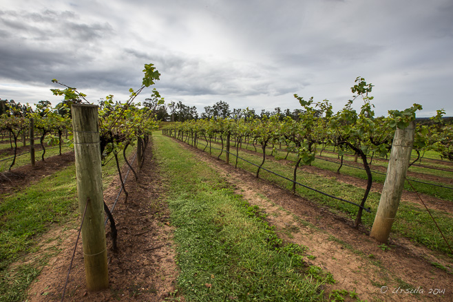
Vineyards All around the Hunter Valley, the vines grow in tidy rows under an autumn sky. (14April2014)
The Hunter Valley is one of Australia’s major wine-growing regions.
Pokolbin, less than 200 km north of Sydney, is the centre of the Hunter Valley Wine Country, and a popular destination for weekend getaways and short breaks. With well over 100 vineyards – most with cellar door sales and tastings, and many hosting weddings, musical performances, or conferences – the area boasts restaurants, boutique shops, golf courses, and country guesthouses.
We were lucky enough to be staying in “The Hunter” last week. My husband was attending a regional conference in Pokolbin and I got to tag along for the social schedule and copious wine.
I was looking forward to days among the vines. Unfortunately, a month before we headed north I tore a ligament and broke a leg. As a consequence, instead of taking myself off on exploratory field trips, I spent my days in our room before hobbling down for conference dinners.
All was not lost, however. During those long days, I sat with my leg elevated, reviewing photos I took during our two trips to the Hunter last year.
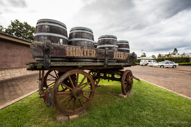
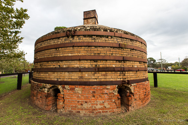
Hunter Beer Co. It isn’t all about the wine. More and more craft breweries are popping up in the area. (13April2014)
Magnolia – – – a restored 1920s brick microbrewery set in spacious landscaped gardens. (13April2014)
Beer Taps It is Australian custom that all beer served be icy cold. (13April2014)
Checking the Beer Potters Brewery offers a short guided tour of the beer-brewing equipment. (13April2014)
“Jack the Bar Guy” Our guide explains the beer-making process …
Tubes and Wires … and lets us into the cooler…
Pulling Beer … before giving everyone samples of the different brews. (13April2014)
Sunset Beer Selfie The shiny beer kegs at the back of the brewery reflect my husband and myself – and the afternoon sun over the landscape. (13April2014)
Grey-Crowned Babbler – Pomatostomus Temporals Birds scrabble around in the ground outside our room. (14April2014)
Tourist Shops Wine-tasting tours often include a stop at the Hunter Valley Gardens, where there are delightful gift shops, …
Lilies … coffee shops and restaurants, and (of course) gardens. (14April2014)
Water for Wine The water jugs are full, and the wine glasses are empty: ready for the tasting at the Tamburlaine Cellar Door. (14April2014)
Cheese Lady Our next stop is at the “Smelly Cheese Shop”, where we get to taste-test a number of delicious products. (14April2014)
Tempus Two Looking back over the bowl that the architecturally designed Tempus Two presides over, it is easier to see how concerts with world-class performers can be accommodated here. (14April2014)
Galahs in the Vines (14April2014)
Vines in the Garden The Ernest Hill Wines estate is set in a lovely garden. (iPhone5 – 14April2014)
Water and Wine The water, glasses, and tasting notes are ready for us…
Wine Master … and before long, the wine master appears to introduce us to the wines and the Hill family traditions. (14April2014)
Workboots Nothing says “country” like workboots at the entry. Vinden Estate(11October2014)
Pouring McGuigan … for our hostess to pour out generous samples. (11October2014)
Sun in the Vines The sun rises high in the sky over the spring growth… (iPhone5 – 11October2014)
Sunset in the Vines … before setting over the vineyards and the surrounding mountains – signalling the end of another Hunter Valley break. (iPhone5 – 11October2014)
It’s a great area to visit – the wine just makes it better.
Gypsy Mother Is there anywhere in the world where people strike poses more naturally and spontaneously than in India?
Rajasthan, in Northern India, is a sensory banquet.
I love the colour.
I even love the chaos and the heat.
But, most of all, I love the photogenic nature of the people. Most seem completely un-hurried, with an internal stillness I can’t help but admire. Every-which-way you turn, you will find people draped in doorways or lounging in lanes. In their vividly colourful clothing, they contrast wildly with their surrounds. I tilt the lens of my camera and make eye-contact, gaining wordless permission to make a photograph. Or, I chat (with or without a language in common) with people who take selfies with their arms around me; I have just become someone’s new best friend.
My last trip to India’s north was in November 2013, in a small group with photographer Karl Grobl and local expert DV Singh. After a morning with tripods on a cold Jaisalmer rooftop (Jaisalmer Morning), Karl let us loose on our own inside Jaisalmer Fort.
It was, of course, a photographic feast.
Sun Rising over the Fort Built in 1156, the UNESCO listed Jaisalmer Fort is a beautiful structure and one of the largest fortifications in the world.
Tightrope Walker The ancient walls provide a magnificent backdrop to the life inside.
Concentration The young boy walking high above the ground concentrates …
Acrobat’s Mother … as his proud mother watches on.
The Boys A group of boys hang around watching the tightrope walker and the tourists.
Gypsy Musicians In an entryway, Rajasthani gypsy musicians entertain…
Beautiful Gypsy … and sell jewellery …
Rajasthani Dolls … and trinkets.
Young Salesman Inside the courtyard of the fort, salespeople sit waiting for customers …
Woman Carrying … while residents go about their business.
House in the Fort The fortress walls enclose homes and shopfronts.
Woman in the Fort
Inside the Hindu Temple A priest sits in a prayer alcove …
Family at the Temple … as a young family comes to pay their respects.
“Use Me” There are nooks and crannies…
Inside the Fort … and alleyways …
Old Jaisalmer House-Front … leading to houses …
Cannon over Jaisalmer … and to a stairway to one of the towers that overlooks the Golden City.
Tourists at the Fort
Crowd in the Market Back down from the gun-tower, the streets are crowded with markets and tourists.
Girlfriends These young women are on holidays together from a nearby state.
Saleswoman A saleswoman spruiks her wares, …
Painting Postcards … a man paints used postcards for re-sale, …
Women on the Stoop … and local woman sit and gossip.
Brahman Cow Down another laneway, I manage to get past a brahman cow, …
Kids in a Corner … only to come across two young girls who appear to be living in a cubbyhole.
Kid in a Corner The younger of the two girls was bright and engaging and seemed to be the protector.
Kid in a Corner As far as I could tell from broken discussions with a neighbouring resident, the mother of these girls had fallen on hard times.
Kids in a Corner So, I gave the girls a few rupee in the hope it will be well spent.
Man and Son Back in the courtyard, a man pauses to pose with his son…
Women in the Courtyard … as do three friends on a day out …
Man and Child … and another man with his child.
Father and Children As I leave the fort, one of the things that strikes me is how many of the groupings I have photographed are friends and family.
Friends and family. Nice!
What makes Northern India so satisfying is that feeling that there is a presence underneath the easy smiles: a faith in ones own values, with no need to impose those values on others.
This is part of what makes for such a good experience.
Great photos Ursula, and great timing too, as I’m heading there to start this year’s tour very soon. I seem to recall a ceremony that took place in your hotel room involving fire and smoke 🙂 ah, the memories. Always awesome to travel with you and I always enjoy reliving the trips through your images and words. Thanks for sharing everything through your blog. Cheers, KarlReplyCancel
Black Hat Dancer In the “Shana Cham” –or “Black Hat Dance” –the dancers represent powerful yogis who can destroy and create life: Wangduephodrang Tsechu, Wangduephodrang, Bhutan.
Over the last few weeks, Bhutan, that Haven of Happiness, has been making an appearance in my various electronic news feeds and re-asserting itself into my consciousness. In part, this is because it was around this time of year, six years ago, that I visited.
I was in this beautiful Himalayan Kingdom for two weeks in September 2009, as part of a tour with photographers Gavin Gough and Jackie Rado. We traveled across Western and Central Bhutan in a bus, with our stops timed to coincide with major tsechus (Dzongkha: ཚེས་བཅུ།, literally “day ten”) – annual religious festivals grounded in Tibetan Buddhism. Between three- and five-days long, the festivals comprise a program of Cham dances: costumed, masked dances that depict religious history and moral teachings. Accompanied by percussion instruments, the rhythmic dances are considered a form of meditation and an offering to the gods; they bring merit to participants and audience alike.
The first festival we attended was at Wangduephodrang Dzongkhag Dzong(the “Administrative Fortress” of Wangduephodrang) in Central Bhutan. This is the same temple-fort which made the international press when it burnt to the ground in June 2012. The loss of the original wooden landmark, built between 1638 and 1639, was considered a great tragedy and cause for national mourning. Reconstruction – in the original style but with modern amenities and fire-safety measures – started early 2014 and is expected to be completed by December 2018. In the mean time, the annual Wangduephodrang Tshechu has been held at the nearby Tencholing Army Ground.
So, we were very luck to be there to appreciate the tshechu in its age-old setting.
There are just a few rules to observe for visitors in this very traditional culture: covered arms and legs are expected inside the temple grounds, and no hats are allowed.
Mist in the Valley It’s a beautiful September morning over the Puna Tsang ChuValley in Wangduephodrang, Central Bhutan. The weather should be fine for the tshechu.
The Audience Inside Wangduephodrang Dzongkhag Dzong, villagers in their best traditional dress are already seated on mats on the ground in the courtyard. The morning sun is still throwing long shadows, but the temperature is already rising.
Venerable Monk The crowd in the courtyard range from the elderly …
Hot Baby … to the very young, …
Young Girl … all dressed in their brocaded finery with snacks at the ready.
Getting Dressed Behind the scenes, dancers get into their elaborate costumes …
The Eye in the Eye … most of which have macabre masks.
Stag Practicing Back-Bends Other dancers limber up back stage …
“Shawa Shachi” … before performing elaborate dances that tell stories …
“Dance of the Stag and Hunter” … of the battle between Ugyen Rimpoche and the King of the Wind.
Black Hat Dancers The black hat dancers feature in a number of the cham dances.
Black Hat : Orange Pants They represent yogis who protect the good in the world and destroy evil.
Black Hat : Red Boots One of their dances portrays victory over a Tibetan king who tried to destroy Buddhism.
Black Hat : Green Brocade Their elaborate outfits swirl around them …
Black Hat Dancer … as they dip and sway, trancelike, …
Black Hat Dancer … in their rhythmic dances.
Inside Wangduephodrang Temple Attending a tshechu gives the watchers blessings and washes away their sins.
Fearsome Animal An ornately dressed dancer in his red mask and horns represents an animal.
Black Hat Dancer The different black hat dances have different rhythms and steps, …
Black Apron … and signify different stories – not that I could recognise which was which.
Spidermen at the Tshechu In a wonderful “clash of cultures”, these boys, wearing Gho (traditional knee-length robes), have their own version of masks to enter the spirit of the dance.
Atsara the “Transcendental Clown” Not all the dances are serious. The Atsara is a clown with a red wooden mask with a big phallus on top. This one seems to be chasing a tiger.
Watching from the Doorway The day grows hotter and spectators cling to small patches of shade as they watch the ongoing dances.
Wangduephodrang Dzongkhag Dzong As I head into the ancient structure and up old wooden stairs, I can’t help but admire the building’s intricate details.
Wolf-Creature The sun gets higher, and more and more wild creatures come out.
Handsome Father
Handsome Son
Black Hat Motion The next group of Black Hat dancers come out …
Black Hat in Motion … swirling in a blur of colour …
Black Hat Motion … and banging their drums.
Old Woman in Pink The building’s soft furnishings are as colourful as the clothing worn by the attendees.
Like a Dream And, the dances continue…
Black Hat Dancers … with countless players. Because so many masked dancers are needed, registered dancers can be fined if they refuse to perform during festivals.
Bhutan is a conservative country, and was closed to international tourists until 1974 – when 300 people visited. Although I was one of 23,480 tourists in 2009, and there were many non-Bhutanese people at the tshechu we attended, I still felt exceedingly privileged to be there. I remember the heat from the unremitting sun beating on my bare head, and the noise from the constant clash of drums assaulting my ears, but I was aware that I was witnessing a tradition that dates back to the 8th and 9th century, when Padmasambhava (Guru Rinpoche), the father of Tibetan Buddhism, recited mantras and performed rites and dances to conquer local spirits and gods – and to convert opponents of Buddhism.
It is always interesting to return to old photos. Reliving the memories is wonderful – but, as I look at pictures taken so many years ago, I can appreciate how much I have learned about photography and about my equipment since then.
It just makes me want to go back and do it all again!
Till then ~
Happy travels!
Photographic notes: pictures taken 26September2009 with my old Canon EOS 400D – edited in Lightroom 5.
Two Trees Deadvlei, in Namib-Naukluft Park, Namibia, is a white clay pan, dried out over 600-700 years ago, dotted with dead camel thorn (Acacia erioloba) trees and surrounded by some of the highest dunes in the world.
Namibia is big.
And dry.
Namibia is the driest country in sub-Saharan Africa, which makes for clear skies, cold nights, and – even in winter – searing-hot days.
Deadvlei (“Dead Marsh”),in Namibia’s Namib-Naukluft Park, almost 400 hot, bumpy kilometres from the capitol, Windhoek, must be one of the driest places in this big country. During a period of drought, some 700+ years ago, the Tsauchab River stopped flowing through the area, and encroaching sand dunes blocked and diverted the river channels. As a result, the flood plain that had played host to camel thorn trees became parched, and the trees died where they now stand: desiccated and preserved by sunshine and dry air.
I posted a few pictures taken in Deadvlei(Portrait of a Dead Tree) back in August, while I was still in the country. I was travelling with a small group lead by Namibian guide Morne Griffiths under the direction of photographer Ben McRae, with Pedro Ferrão Patrício from Photoburst. We made our first excursion into the clay pan late one afternoon before the sun set.
Early the next morning, we were back for another look.
Tree at Sunrise We stayed close to the Sesriem Gate overnight, so as to be on the move as soon as the Namib-Naukluft National Park gates opened in the morning. The desert night temperature was close to 0° C, and it was still cold as we drove to the meeting point to find our jeeps.
Bare Tree
Morning on the Dunes
Dawn Ride
Sunrise over Deadvlei Dunes From the jeep drop-off, it is about a twenty minute walk across shifting sands.
Deadvlei Trees I made it into the white-clay pan before the sun could reach all the way over the dunes.
Deadvlei Tree The surrounding dunes turn orange as the sun rises.
Parched Clay At the edges of the white clay pan…
Leading Lines … a few camel thorn trees somehow find enough moisture to grow in the arid environment.
Deadvlei Landscape The trees in the middle of the pan, however, died and dried out some 700 years ago…
Still Life on Rough Ground … and lie where they have fallen…
Like a Sculpture … or stand like wild creatures against the dunes.
Clay Remnants Patches of white clay curl on the red sands.
Colour Contrasts As the sun climbs over the dunes, the colours become more dramatic…
Tuft of Grass … and the sun glistens off the sands and tough desert grasses.
Incoming Tourists As we make our way out of the clay pan, jeep-loads of tourists walk into the area. Clearly, the pan is going to become crowded as the morning advances.
Climbers on the Ridge
Ripples and Waves
Footprints Some small creature has left its mark in the sands of the dune.
Loo with a View Back at the jeep parking lot, the rising sun packs heat that bleaches the landscape.
Gemsbok (Oryx gazella) As we leave the Namib-Naukluft National Park, an oryx watches us.
It is a fascinating landscape, with a personality all its own.
I was so pleased to have been able to explore it in the relative quiet of the morning, before the arrival of the worst of the heat and crowds.
[…] Dunes of Namib-Naukluft ParkThe next day, after an early-morning visit to Deadvlei (see: Dead Trees and Dunes) we are back in open-air jeeps bumping across the […]ReplyCancel
Perennial Cornflower: Centaurea Montana Wet weather high in the Swiss Alps washes the summer mountain flowers, leaving the colours fresh and bright (iPhone5).
Ever since reading Heidi as a child, and “studying” Switzerland in Grade 3Social Studies, I have dreamed of walking in the flower-filled meadows of the Swiss Alps. When my husband and I planned to visit some Swiss friends last year, I thought my chance had come.
So, if I wanted Heidi’s mountains, I needed a Plan B.
I booked an extra week in Leysin, a village at 1263 metres in the Vaud Alps, high above Aigle in the Rhone Valley (q.v.: A Walk through the Waters), home to international schools and a sports academy, and reputed to be a year-round holiday resort with access to hiking and mountain-biking trails. I imagined myself singing “The Hills are Alive” (ok – wrong country, but same mountain chain…)
One day, when we thought there was enough of a break in the rain, we attempted a hike up hill: aiming for the Berneuse(2048 m.), a near-by mountain-top with a glass revolving restaurant reputed to provide a 360° panoramic view of the Valais mountains and over the Rhône Valley to the Dents du Midi, Lake Geneva and the Jura Mountains.
After we set off, however, the rains started again. With umbrellas and raincoats, we slogged up hill, hoping it would ease – which it did, but not soon enough. Wet to the skins, the highest point we reached was Le Témeley, a fromagerie-buvette (“cheese-refreshment” house) at 1705 metres; well short of our original aim.
The Mountain Village of Leysin Normally mild and sunny with fresh mountain air, this little village on the front face of the Tour d’Aï in the Vaud Alps was a health resort for people with lung diseases in the fifties.
House in Leysin Sloped metal roofs shield homes through winter snow-falls. (iPhone5)
Mountain Goat Thanks to modern laser-cutting, traditional Scherenschnitt (intricate Swiss paper-cutting) patterns are now available in wood. (iPhone5)
Trail-Side Wildflowers For much of our walk up the hill, the rain was too hard to even attempt photos. Finally, it broke.
Happy Cows The cows don’t seem to mind the wet…
Snail … and of course, the large, slow snails love it.
The Chalet Témeley Half-way up our planned route, and rather later (and wetter) than we expected, we arrived at Chalet Témeley: a cheese-making farmhouse operated in summer by the Cornamusaz family.
Welcome to the Alpine “Le Témeley” We’d arrived too late in the day for the standard lunch…
Slabs of Cheese … but thanks to our multi-lingual Swiss friends, Mme. Cornamusaz, the farmer and cheese-maker, took pity on us and let us into the dark outer rooms. Wet and bedraggled, we sat over hot tea and coffee, fresh bread, and huge chunks of home-made AïMountain cheese.
Mist in the Mountains We were warned against trekking any further, as the muddy pathway up the rest of the hill was slippery, steep, and unsafe because of the wet weather. So, after much coffee, cheese and conversation, we headed back down…
Big Masterwort: Astrantia Major … stopping for some flowers on the way.
Walking Marker Path-markers are painted on some of the moss-covered rocks we pass.
Cornflower: Centaurea Montana or Triumfettii The cornflowers – part of the daisy family – were among my favourite path-side wildflowers.
Steep Slopes The evergreens rise sleeply as the mountainside falls away toward the valley.
Flowers on the Verge A delicate mix of wildflowers colours the side of the path.
Globe-thistle: Echinops Sphaerocephalus
Mountains of Vaud From our vantage point, we can look down the mountain to Leysin and Aigle and beyond, to where the clouds sit over the Rhône Valley.
Cows Cows – all wearing bells – wander at will …
Cows … and watch us as we pass …
Cows … before wandering off down the path themselves.
“Glockenblumen” or Bell-Flowers: Campanula Rotundifolia Raindrops cling to the leaves and petals of the bellflowers …
“Glockenblumen” or Bell-Flowers: Campanula Rotundifolia There are more than 50 species of bellflower in the Alps.
Wild Roses
Down the Hill We work our way back down the hill…
Farm House with a View … past farmhouses before arriving back in the village.
Even though we walked half as far as we had planned, we arrived back at our lodge wetter and more tired than I had expected. The cold mountain rains had sucked all the warmth and energy out of us. But, we enjoyed our evening meal all the more for it.
I’m stuck in an armchair at the moment, with a pair of crutches at my side. It was another mountain that put me here – well, to be fair, it wasn’t the mountain’s fault: the Australian spring snow was heavy, my ski bindings were too tight, and I took a clumsy fall. No “weight-bearing” for many weeks for me.
So, I sit dreaming of walks in mountains.
Even a wet, cold walk has its beauty – and is better than no walk at all.
[…] Château de Chillon; Schaffhausen and Neuhausen am Rheinfall; Gruyères; The Salt Mines of Bex; Leysin; Lucerne; […]ReplyCancel
Noemia Maxwell -June 20, 2019 - 10:08 pm
I would love to walk around the area and would appreciate any advice on guided walks, sites, hotels or guest houses.
I fell in love with your photos!ReplyCancel
Hi Noemia,
Thanks for your visit! There is plenty of accommodation in town. We just picked up a local map for walks, etc, from our accommodation, but you can get information from the official Swiss tourism site (https://www.myswitzerland.com/en/ ).
Cheers! UrsulaReplyCancel
- Performing the Ganga Aarti from Dasaswamedh Ghat, Varanasi
- Buddha Head from Shwedagon Pagoda, Myanmar
- Harry Clarke Window from Dingle, Ireland
- Novice Monk Shwe Yan Pyay Monastery, Myanmar
Packets of 10 for $AU50.
Or - pick any photo from my Flickr or Wanders blog photos.


 It’s a great area to visit – the wine just makes it better.


 This is part of what makes for such a good experience.


 It just makes me want to go back and do it all again!


 Even a wet, cold walk has its beauty – and is better than no walk at all.


")
