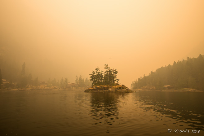
Entrance to Princess Louisa Inlet
The light through the smoke from a 20,000 hectare forest fire in the Elaho Valley some 20 kilometres away casts a muddy orange hue over the entrance to Princess Louisa Inlet in BC.
“There, to your left, you can see one of British Columbia’s highest waterfalls,” our guide and boat operator Tim said – and laughed, because we couldn’t see the cliffs rising either side of us, or the waters falling from the tops, or indeed, anything more than four feet away.
Forest fires are raging across British Columbia in Western Canada at the moment. While this is not uncommon in the province’s Interior, the coastal regions – with their maritime climate and frequent rains – are much less used to uncontrollable burns. But, there was less than usual snowfall in the coastal mountains last winter, higher than normal spring temperatures, and less than expected precipitation. So, the extensive forests are dry in the extreme.
Last Saturday (July 4th 2015) when we entered the north side of the Sechelt Peninsula, the day was sunny and hot and the skies were brilliantly blue and clear. Sunday morning, however, the air over Sechelt was full of smoke from the Old Sechelt Mine fire, one firefighter was dead, and a number of homes were on evacuation alert.
We were well out of the danger zones, and thought we’d be fine the next day – an hour’s drive and a two hour boat trip away – in the Princess Louisa Inlet. I checked with the operator of the tour we planned to take: “Will the visibility be ok?” I asked. “No problem!” she assured me.
I guess it is all relative.
Reputed internationally as an area of stunning beauty, the 6 kilometre (3.7 mi) inlet is preserved as a Provincial Marine Park for its unique ecological system. Sheer granite walls, carved out by glaciers millennia ago, rise more than 2,100 metres (7,000 feet) above the still waters in the Pacific coast’s only true fjords.
Of course, with the dense smoke from the uncontrolled 20,000 hectare forest fire in the Elaho Valley, some 20 kilometres away in the Coast Mountains northwest of Whistler, we could see very little of the magnificent scenery we knew to be around us.
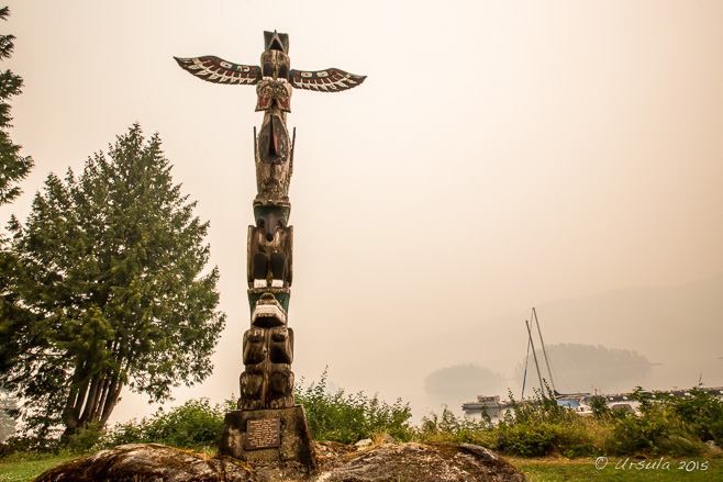
Welcome Totem Pole
When we arrive at the Back Eddie Pub in Egmont – the starting point of our tour – we can hardly see the islands across the small harbour.
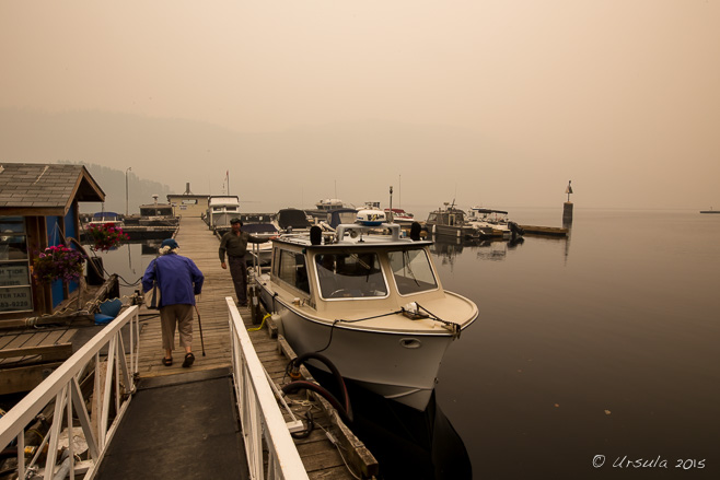
Tour Boat
Smoke hangs in the air and ash falls like snow as passengers make their way to the Sunshine Coast Tour boat, which will take us the roughly 90 km north to the entrance to the Princess Louisa Inlet.

Our Guide Tim
Our guide gives us a detailed commentary – when he is not sounding the fog horn and trying to steer through the obscurity.

Private Island
Many of the islands around Egmont are privately owned. This one is said to be the small town’s “biggest employer”, as maintenance staff work year round.

The Waters
The waters of Jervis Inlet spread out behind us as we speed north.

The Woods around Jervis Inlet
The sun is red overhead, casting an orange glow as it tries to illuminate the inlet through the smoke and ash. We can only just distinguish the trees on the rocky shoreline.

Soda Creek Waterfall
Our first stop is to admire a waterfall pounding down from the glacier in the mountains above. Young men of the Sechelt Indian Band used to prove their fortitude by standing in the glacial waters on the ledge at the base of the falls. They then demonstrated their bravery by diving from the top.

Petroglyph
The first petroglyph we stop to look at, just before Vancouver Bay, is thought to be up to 4000 years old. It is believed the picture was last “touched up” about 300 years ago.

Granite and Iron Foreshore
Even through the smoke, we can see the coloured striations of the rocky shores of Jervis Inlet.

Petroglyph
Our second petroglyph is high on a rocky ledge, and hard to see through the smoky air.

Bald Eagle
High in the ashy trees, a bald eagle keeps watch; its partner is surely nearby.

“Beyond Malibu”
These waters off the British Columbia coast have long been visited by colourful characters. Herman Caspar, who was a squatter with no legal rights to the property, sold the land at the entrance to the Princess Louisa Inlet to American aviation executive Thomas F. Hamilton for $500 in 1940. Hamilton wanted to build luxury resorts for visiting yachtsmen and Hollywood celebrities. Unfortunately, his grand plans came to little when someone contracted polio in in 1950, and the resort was abandoned by panicked staff and customers alike. In 1953, the property was bough by Young Life, Presbyterian Minister Jim Rayburn’s organisation, and it has run as a Christian summer camp for teenagers ever since.

Seals
Only the eyes of the local harbour seals can be seen through the water and haze.

Princess Louisa Wharf
We tie up at the dinghy dock to lunch at the picnic tables in the Princess Louisa Marine Provincial Park.

Princess Louisa Marine Provincial Park
The pathway into the woods is a welcome respite from the smoky air.

“Laird of the Inlet”
Another priceless character, James F. “Mac” MacDonald (1889-1978), bought 45 acres (18 ha) of wilderness in 1919. Rather than profit from its sale, he set up the Princess Louisa International Society and donated the lands to it in 1953. Since 1964, the area has been managed jointly by the Society and BC Parks. The moss and lichen surrounding the plaque in the park is crisp and brown from heat and lack of water.

Picnic Hut
This hut is dedicated to James F. “Mac” MacDonald, the originator of the park. When he built his first cabin in the here, “Capi” (M. Wylie Blanchet) had already been visiting the area with her five children for some years.

Moss and Flowers
Inside the forest, it is still hot and buzzing with mosquitos, but there are ample rewards.

Loquilts River Waters
Mossy rocks and logs divert the Loquilts River waters at the base of the famous Chatterbox Falls.

Chatterbox Falls
Because of the smoke and haze, I found the best view of the famous Chatterbox Falls was from far below. One day, I will get back in good weather, and take the classic “full frontal” shot that adorns all the literature!

Malibu Rapids
Many boats can only cross the Malibu Rapids at slack tide. Although the narrow stretch of water is short, it is fast moving (approximately 9 kn or 17 km/h) and creates eddies and whirlpools that are dangerous to small craft.

Another Waterfall
Turning into Queen’s Reach, we pass another waterfall, and a private boat dock for Beyond Malibu.

Rocky Coast
As we return to base, we sometimes imagine the smoke has lifted – but I suspect we have just got rather used to it.

Seals on “No Tree Island”
On what was once “One Tree Island”, the seals pile up on the seaweed at the waterline.

Jellyfish
Back at our boat dock, we observe the jellyfish…

Great blue heron (Ardea herodias)
… while a heron watches the harbour.
Editing my raw pimages was a challenge: all my pictures looked as if they had been run through a sepia filter. I suppose the new Lightroom CC would de-haze all my photos, but would that then accurately represent the day we had experienced?
We had some discussion, when we arrived home, about whether or not we should have been expected to go on the tour, given the dangerous air quality and low visibility.
But, on the other hand, that is the nature of Nature.

She is unpredictable. And we need to appreciate all her colours –
Including sepia.
Till next time!
Pictures: 06July2015



.jpg)

